
Turn your aerial images into stunning marketing visuals in seconds
AerialPin automatically detects your drone location, finds nearby amenities, and creates professional POI overlays ready for real estate marketing.

Try it now
Drop your own aerial photo. Real coordinates, real places, read in your browser.
Try it: drop your own aerial photo
Watch it do the work
Real recordings of the editor, not mockups.
Pins placed for you, from the photo's own data
AerialPin reads the GPS position, altitude, compass heading and gimbal angle stored in your drone photo, works out which nearby places the camera can actually see, and drops the whole set of labelled pins in one press.
- Positions computed from the photo, not a template
- Anything outside the frame is left out, not nudged in
- Choose how many pins and which categories to look for
Shoot at noon. Sell at golden hour.
Relight an aerial photo to a different time of day in about a minute. Bright day, golden hour, twilight or a clear sky over an overcast shoot. Only the sky and the light falling on the scene change: the building, the ground and the landscaping stay exactly as photographed.
- Four looks: bright day, golden hour, twilight, clear sky
- Standard or high resolution, priced separately
- Every version is kept, so you can compare and switch back
- The original is never altered and always one click away
One photo, four times of day
Every column is the same shot, relit. Press one to expand it. Nothing on the ground moves.
Press a column or a look to expand it
Trace the block with a few clicks
Click points straight onto the aerial shot to draw a property boundary. Fill, stroke and spotlight are all adjustable, every edge can carry its length, and the total area is calculated as you go.
- Click-to-place points with snapping
- Fill, stroke and spotlight the block
- Edge lengths and total area, in metric or imperial
Make every listing look like yours
Change pin shape and colour, label typography, borders and leader lines, then save the lot as a template. Apply it to the next photo and a whole set of listings comes out looking like it came from one place.
- Thirteen typefaces, full colour control
- Save styles as reusable templates
- Agency presets to start from
Stitch the whole view, annotate it in 3D
Drop in a set of overlapping drone shots and AerialPin stitches them into one 360° sphere — in your browser, with nothing uploaded. Then spin the view and work on it: pins on what you can actually see, property boundaries traced round the plot, the same styling as any other photo, and an export that opens as a proper 360 anywhere.
- Stitched on your own machine, never uploaded
- Pins and boundaries placed while you look around
- Exports with 360 metadata for Google, Facebook and the rest
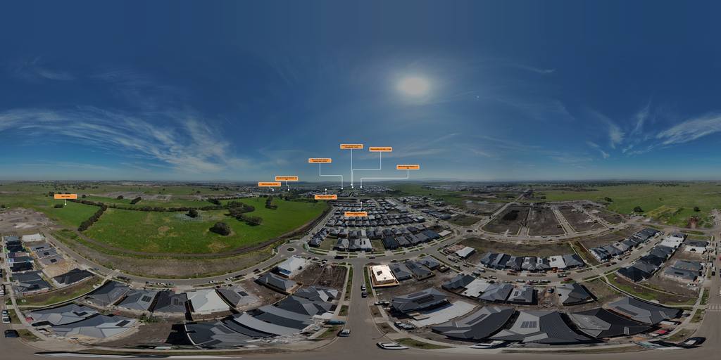
A real AerialPin stitch, blended in the browser. Drag to look around, pinch or scroll to zoom, and open it full screen.
Built for real aerial workflows.
Label
Build clearer visual context
Drop labels that sit naturally within the scene, styled to match the rest of your work. Everything stays readable and organised, even on dense sites.
- Custom label styling with your own colour system
- Pre-built layouts for fast setup
- Save and reuse styles across projects
Discover
Nearby POIs, found automatically
Pull real points of interest straight from Google Places (schools, transit, parks, retail) so you're not hunting for context by hand.
- Auto-populate nearby schools, transit, and amenities
- Filter results by category and distance
- Drop a discovered POI onto the canvas in one click
POI
Points of interest that describe space
Labels aren't just markers, they become structured information. Especially useful for sites where a single pin can't tell the whole story.
- Rename and edit POIs directly on the canvas
- Control anchor position and text layout
- Draw and define areas with flexible shapes
Export
Export when you're ready
Once your layout is complete, generate clean outputs ready for clients or reports, delivery-ready without extra steps.
- Batch export multiple images
- Control resolution and output quality
- Delivery-ready formatting without extra steps
Everything you need on one aerial photo
Four tools that take a raw drone image through to a finished listing visual.
Scale based on how often you work.
Every paid plan includes every feature. The only difference is how many credits you get.
10 credits to start
Yours to keep, no subscription and no card. Enough for 1 AI Auto Place run, plus 3 free AI runs to spend on nearby search or Auto Place.
Starter
50 credits / mo
For pilots getting started with aerial annotation.
- AI Auto Place, automatically find and place locations
- Nearby hotspot search, find nearby locations to manually add
- AI Relight, change the sky and time of day
- Bright day, golden hour, twilight and clear-sky looks
- Your own logo as a marker, uploaded and private to you
- Original-resolution exports
- All label styles
- Batch export
Pro
150 credits / mo
The most commonly used tier. Everything you need.
- AI Auto Place, automatically find and place locations
- Nearby hotspot search, find nearby locations to manually add
- AI Relight, change the sky and time of day
- Bright day, golden hour, twilight and clear-sky looks
- 360 panorama image stitching
- Interactive 360 panorama viewer
- Your own logo as a marker, uploaded and private to you
- Original-resolution exports
- All label styles
- Batch export
Business
500 credits / mo
For higher-volume workflows and larger sites.
- AI Auto Place, automatically find and place locations
- Nearby hotspot search, find nearby locations to manually add
- AI Relight, change the sky and time of day
- Bright day, golden hour, twilight and clear-sky looks
- 360 panorama image stitching
- Interactive 360 panorama viewer
- Your own logo as a marker, uploaded and private to you
- Original-resolution exports
- All label styles
- Batch export
Agency
2,000 credits / mo
High-volume production at team scale.
- AI Auto Place, automatically find and place locations
- Nearby hotspot search, find nearby locations to manually add
- AI Relight, change the sky and time of day
- Bright day, golden hour, twilight and clear-sky looks
- 360 panorama image stitching
- Interactive 360 panorama viewer
- Your own logo as a marker, uploaded and private to you
- Original-resolution exports
- All label styles
- Batch export
How credits work
- Export image
- 1 credit
- Nearby search
- 5 credits
- AI Auto Place
- 8 credits
- AI Relight 2K Resolution
- 10 credits
- AI Relight 4K Resolution
- 15 credits
Use your credits however you like. A monthly plan refills at the start of each billing period; a yearly plan grants the whole year at once. Extra credits you buy never expire.
A single workspace
Imagery with meaning. Delivered.
Start with 10 free credits. No card required.
Create free account