
360° Aerial Panorama Stitching
Fly the sphere, drop the folder in, and AerialPin stitches it — in your browser, with nothing uploaded. Then annotate it the way you will look at it: spin the view, drop pins on what you can see, trace the boundary round the plot, and export a file that opens as a proper 360 anywhere.
Free to start, no credit card required.
How to Automatically Label Real Estate Drone Photos with AI · Watch on YouTube
How to use 360 Panorama
Fly the panorama
Any overlapping set works — a full sphere from your drone's panorama mode, or a hand-flown ring. Shoot it from one spot.
Drop the folder in
The stitch runs in your browser on your own machine. Nothing is uploaded, and a large set is a few minutes rather than an upload queue.
Look around it
Switch to 360 view and spin the sphere. The horizon is levelled and the seam is closed, so it reads as the place rather than as a strip of photos.
Annotate in 3D
Drop pins on what you can see and trace the boundary round the plot. Both are stored as directions, so they stay put as you turn.
Style it and export
The same markers, labels and boundary styling as any other photo. The export carries the 360 metadata, so it opens as a sphere everywhere.
Why use 360 Panorama?
Stitched on your machine
Feature matching, bundle adjustment, seam finding and blending all run in the browser. A panorama never leaves your computer to be made.
Annotate where you can see
Pins and boundaries are placed while looking around the sphere, not on a stretched flat strip where nothing is the shape it really is.
Straight lines stay straight
A boundary edge is drawn as the sphere's own straight line, so a fence traced in the viewer is a fence in the finished file rather than a bowed curve.
Opens as a 360 anywhere
The export carries the standard panorama metadata, so Google Photos, Facebook and the usual web viewers all open it as a sphere.
Built for property marketing
The defaults are set up around real estate drone photography rather than general-purpose image editing.
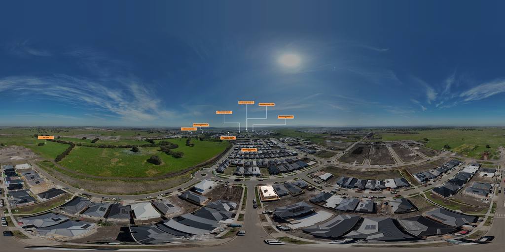
A real AerialPin stitch — 34 frames from one hover, blended in the browser. Drag to look around, pinch or scroll to zoom, and open it full screen.
See AerialPin in action
The viewer above is the editor's own: the same shader, the same camera and the same sphere maths the app annotates with. What you drag here is what you would be working in.
360 Panorama questions
How do I make a 360 panorama from drone photos?
Shoot an overlapping set from one spot — most drones have a panorama mode that does this — then drop the folder into AerialPin's Panorama tool. It matches the frames, works out where each camera was pointing, levels the horizon and blends them into one equirectangular image.
Is my panorama uploaded to a server to be stitched?
No. The whole stitch runs in your browser on your own machine, so the photos never leave your computer.
Can I add pins and boundaries to a 360 panorama?
Yes, and you do it while looking around the sphere. Pins, labels and property boundaries are all stored as directions rather than as flat positions, so they stay attached to what they are pointing at however you turn the view.
Will the exported panorama open as a 360 elsewhere?
Yes. The exported file carries the standard GPano metadata, so Google Photos, Facebook and the common web viewers recognise it as a sphere rather than showing a stretched flat image.
How many photos do I need?
As few as two overlapping frames will stitch. A full sphere from a drone's panorama mode is usually somewhere between twenty and forty, and AerialPin handles a set that size in a few minutes.
Ready to create better aerial property images?
Create your free AerialPin account and start using 360 Panorama today.
Create your free account