
7 Tools Every Real Estate Drone Photographer Should Have
Discover 7 tools and workflows for real estate drone photographers, including EXIF data, GPS, nearby locations, AI pin placement, property boundaries and AI relighting.
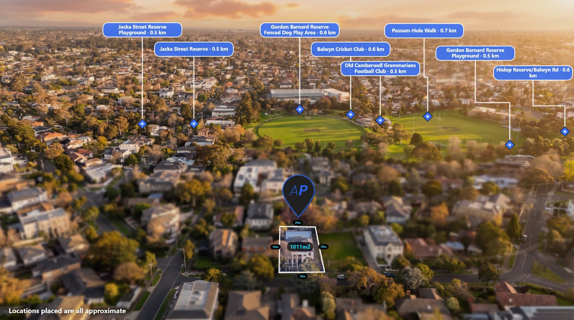
Real estate drone photography has become an important part of property marketing.
Aerial images can show the size of a property, its surrounding area and nearby amenities in a way that traditional property photography cannot.
But capturing the drone photo is only one part of the workflow.
Professional real estate photographers also need tools for checking image metadata, finding nearby locations, adding property information, creating consistent annotations and preparing images for marketing.
Here are seven useful tools and workflows that can help make real estate drone photography faster and more efficient.
1. A Drone EXIF Viewer
Your drone photographs can contain valuable metadata.
EXIF data can include information such as:
- GPS coordinates
- Altitude
- Camera heading
- Gimbal angle
- Camera model
- Lens information
- Date and time
This information can be particularly useful when creating annotated aerial photographs.
AerialPin EXIF Info lets you inspect the metadata inside your drone photograph.
For real estate photographers, checking the EXIF data can help confirm that the original image contains the location and camera information needed for location-based workflows.
2. A Nearby Location Search Tool
Aerial property photographs become much more useful when you can show what's around the property.
Nearby locations might include:
- Schools
- Shopping centres
- Parks
- Train stations
- Roads
- Beaches
- Sporting facilities
- Supermarkets
- Cafes
Instead of manually searching maps for every property, a dedicated nearby search tool can make the process much faster.
AerialPin Nearby Search lets you search for nearby points of interest and choose the locations you want to include in your aerial marketing image.
You can use the property location as the starting point and find relevant amenities around it.
3. An AI Pin Placement Tool
Finding a nearby location is one thing.
Knowing where to put its label on the actual photograph is another.
Aerial photographs aren't maps.
The camera is looking in a specific direction, from a specific altitude and angle.
AerialPin AI Auto Place uses information from the drone photograph to help determine which nearby locations are relevant to the camera's view and position the pins on the image.
You can then review the result and make adjustments.
This can be much faster than manually positioning every location.
4. A Property Boundary Tool
Property boundaries are one of the most common annotations used in real estate aerial photography.
A boundary helps buyers understand exactly which land is being marketed.
This is particularly important for:
- Acreage
- Development sites
- Vacant land
- Large blocks
- Rural properties
- Commercial properties
AerialPin lets you create property boundary overlays directly on your drone photograph and customise their appearance.
Combining a boundary with nearby locations can create a complete visual overview of the property.
5. A Drone Photo Styling Tool
Aerial annotations should look professional.
If you regularly photograph properties for real estate agencies, you may want your aerial images to follow a consistent visual style.
AerialPin Styles lets you customise the appearance of your annotations and save reusable styles.
You can create consistent settings for things such as:
- Pins
- Labels
- Fonts
- Colours
- Borders
- Leader lines
- Property boundaries
Once you've created a style you like, you can reuse it on future projects.
This is especially useful when working with multiple agents or agencies.
6. An AI Relighting Tool
Lighting can have a major impact on property photography.
Sometimes the aerial composition is perfect but the weather isn't.
You might capture a property under an overcast sky and later wish you had a warmer, more dramatic image.
AerialPin AI Relight can create different lighting looks from an existing aerial photograph.
Depending on the workflow, you can create options such as:
- Golden hour
- Twilight
- Bright day
- Clear sky
This can give you additional creative options without needing another drone flight.
7. A Workflow That Uses Your Drone's Metadata
The most useful tool isn't necessarily another piece of software.
It's a workflow.
Your drone photograph may already contain information that can help automate parts of the editing process.
For example:
Drone GPS
↓
Property location
↓
Nearby locations
↓
Camera direction
↓
Visible points of interest
↓
Automatic pin placement
↓
Property boundary
↓
Branded annotations
↓
Finished aerial marketing image
AerialPin is designed around this type of workflow.
Instead of treating the aerial photograph as just a picture, it uses the information contained in the image to help build a more useful marketing asset.
Why Real Estate Photographers Need Faster Workflows
Real estate photography is often a high-volume business.
You may photograph several properties in one day and then spend hours processing and delivering the images.
Small tasks can become significant time drains when repeated across dozens of listings.
Searching for nearby locations might take several minutes.
Manually positioning pins might take several more.
Creating the same annotation style repeatedly adds more time.
Checking metadata in a separate application adds another step.
A streamlined workflow can reduce these repetitive tasks.
Use the Original Drone Image
If you're using GPS and EXIF data, start with the original drone photograph whenever possible.
Editing software and messaging platforms can sometimes remove metadata from image files.
If the original image contains GPS coordinates and camera information, keeping that file gives you the best starting point for location-based tools.
You can use AerialPin EXIF Info to check what information is available.
Turn Drone Photography Into a Marketing Service
Real estate photographers don't necessarily have to sell only the photograph.
You can offer additional aerial marketing services around the image.
For example:
Standard aerial photograph
A professionally edited drone photograph.
Annotated aerial photograph
The property boundary and important nearby locations are added.
Marketing aerial package
Annotated images, custom styling and alternative lighting versions.
Adding these services can make your drone photography offering more valuable to real estate agents.
Create Better Aerial Images With Less Manual Work
The goal of using these tools isn't to remove the photographer from the creative process.
The photographer still controls the image.
You decide which photograph to use, which locations matter, how the property should be presented and how the final image should look.
The tools simply reduce the repetitive work.
AerialPin brings these workflows together so real estate photographers can spend less time manually creating annotations and more time focusing on photography and clients.
Start Building Your Aerial Photography Workflow
If you regularly create drone images for real estate, look at the entire workflow rather than just the photography.
Check the metadata.
Find the important nearby locations.
Automatically position your labels.
Add the property boundary.
Apply your branding.
Create alternative lighting options.
Then export the finished marketing image.
With the right workflow, your drone photographs can become much more than simple aerial pictures.
They can become complete property marketing assets.
Capture the image. Use the data. Add the context. Deliver a better aerial marketing image.