
Add Easy & Professional Looking Address Labels for Aerial Images!
Excerpt: Learn how to add professional address labels to aerial images for real estate marketing. Discover how AerialPin helps drone photographers create clean, accurate and branded aerial photos faster.
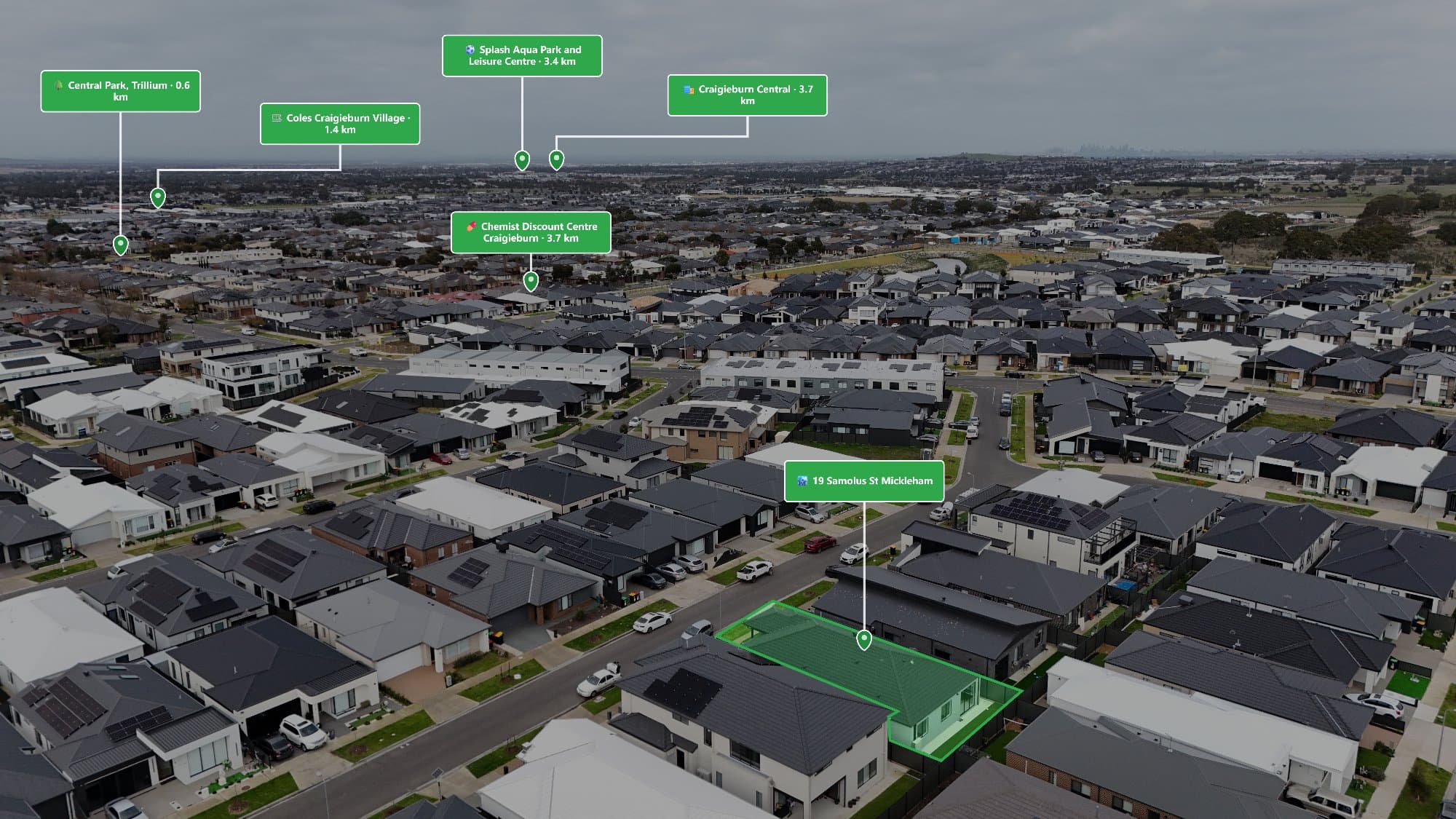
Create professional aerial marketing images with clean address labels that help buyers instantly understand property locations. Learn how AerialPin makes adding location information to drone photos faster and easier.
Aerial images have become an essential part of modern real estate marketing. They allow buyers to see a property's layout, surrounding streets and overall location from a perspective that traditional photography cannot provide.
However, one challenge with aerial photography is that viewers may not always know exactly where the property is located.
Adding an address label to an aerial image solves this problem by providing instant location context while maintaining a professional presentation.
With AerialPin, photographers can quickly create polished aerial images with accurate location labels, helping agents, builders and property marketers deliver better marketing content.
Why Add Address Labels to Aerial Images?
An aerial photo shows the property, but an address label tells the viewer exactly what they are looking at.
Professional address labels can help:
- Identify the property's location
- Improve listing presentation
- Create branded marketing material
- Make social media posts easier to understand
- Provide additional context for buyers
For real estate marketing, small details like clear location information can make a significant difference.
The Importance of Location in Real Estate Marketing
Real estate is about more than the building itself. The surrounding area often influences a buyer's decision.
An address label helps connect the image with the property by showing:
- The street location
- The surrounding neighbourhood
- The property's position within the area
This is especially useful for:
- New developments
- Luxury properties
- Acreage homes
- Display homes
- Off-market campaigns
The Traditional Way to Add Address Labels
Many photographers create address labels manually using design software.
The process usually involves:
- Opening the aerial image in Photoshop or Canva
- Creating a text box
- Designing a label style
- Typing the address manually
- Positioning the label correctly
- Exporting the final image
While this works, it can become repetitive when producing multiple property images.
What Makes a Professional Address Label?
A high-quality address label should be:
Clean and Easy to Read
The label should provide information without distracting from the image.
Consistent With Branding
Fonts, colours and styling should match the overall marketing design.
Correctly Positioned
The label should complement the aerial composition and avoid covering important property features.
Suitable for Different Platforms
The image should work across:
- Real estate websites
- Social media
- Property brochures
- Digital advertising
How AerialPin Makes Address Labels Easier
AerialPin helps photographers create professional aerial marketing images without spending time on repetitive editing tasks.
Instead of manually designing every label, photographers can use AerialPin to create location-focused images quickly.
The workflow is simple:
Upload Your Aerial Image
Upload your drone photo and let AerialPin process the image.
Add Location Information
Use location data and image information to create accurate labels.
Customise Your Style
Create a professional look that matches your marketing requirements.
Export Your Final Image
Download a finished aerial image ready for:
- Property listings
- Social media campaigns
- Builder presentations
- Marketing brochures
Address Labels vs Point of Interest Labels
While address labels and Point of Interest (POI) labels are both useful, they serve different purposes.
Address Labels
Address labels identify the main property location.
They are useful for:
- Property listings
- Development announcements
- Project marketing
Point of Interest Labels
POI labels highlight nearby locations such as:
- Schools
- Parks
- Shopping centres
- Transport
- Restaurants
Together, they create a complete picture of the property and its surroundings.
Why Real Estate Photographers Use Aerial Labels
Professional aerial labels help photographers provide more value to clients.
Instead of delivering a standard drone image, photographers can offer marketing assets that:
- Explain location advantages
- Improve buyer understanding
- Look more premium
- Stand out online
This creates a stronger service offering for real estate agents and property businesses.
Who Benefits From Address Labels?
Real Estate Photographers
Create premium aerial packages and deliver more useful images.
Real Estate Agents
Help buyers quickly understand property locations.
Builders
Showcase project locations and developments.
Property Developers
Communicate the position and advantages of new projects.
The Future of Aerial Marketing
Aerial photography is becoming more informative.
Modern buyers expect more than attractive images. They want context, information and a better understanding of the property.
Tools like AerialPin help transform simple drone photos into professional marketing assets by combining aerial imagery with location information.
Final Thoughts
Adding an address label to an aerial image is a simple way to make property marketing more professional and informative.
A clean, well-designed label helps buyers understand exactly where a property is located while improving the overall presentation of the image.
With AerialPin, drone photographers can create professional aerial marketing images faster with accurate location information, helping properties stand out in a competitive market.