
Add Property Lines on Aerial Real Estate Shot?
Want to add property lines to an aerial real estate photo? Learn how to create clean boundary overlays that make the property easier to understand, plus a faster way to do it with AerialPin.
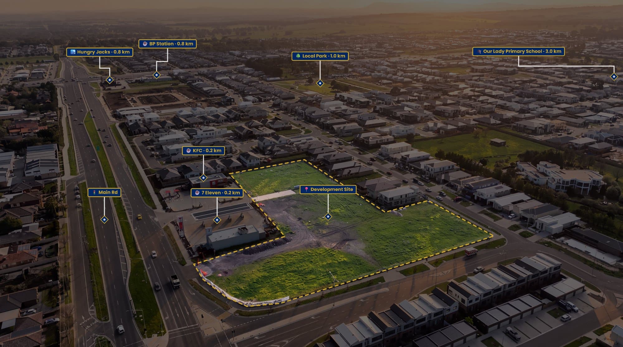
An aerial real estate photo can show a property from a perspective that you simply can't get from the ground.
But there's one problem.
Where does the property actually end?
From above, neighbouring blocks can look almost identical. Fences might be hidden by trees, landscaping can blur the edges and large properties can be difficult to understand.
Adding a property line gives the viewer an immediate answer.
Why Add Property Lines?
A simple boundary overlay can make an aerial image much more useful for a property listing.
It's particularly helpful for:
- Large backyards
- Acreage properties
- Vacant blocks
- Development sites
- Corner properties
- Properties with unclear fencing
- Large parcels of land
Instead of making a buyer guess which land belongs to the listing, you can show the area directly on the image.
How Do You Add the Line?
The first step is getting reliable property boundary information.
You can use appropriate property mapping, cadastral information, a property plan or other verified data to identify the boundary.
From there, you can overlay the boundary onto the aerial photograph.
If you're using Photoshop, you can create a new layer and use the Pen Tool to trace the property. Adjust the stroke width, colour and opacity until the line is easy to see without distracting from the photograph.
It works, but there's a fair amount of manual work involved.
A Faster Option for Real Estate Photographers
If you're doing this regularly, AerialPin gives you a much quicker way to create the overlay.
Upload your drone image and create the property boundary directly on top of the photograph.
You can customise the boundary, add a transparent fill, create a spotlight around the property and add labels.
So instead of opening multiple programs and building the graphic manually, you can handle the aerial annotation in one place.
Make the Property Stand Out
A boundary line isn't the only way to highlight a property.
A subtle spotlight can darken the surrounding area while keeping the subject property brighter.
This works particularly well when the property is surrounded by houses, roads or other blocks of land.
The combination of:
Boundary + Spotlight + Property Label
can make it immediately obvious which property is being marketed.
The key is keeping the effect subtle. You want the property to stand out, not make the image look like a graphic design project.
Add What's Nearby
You can also use the same aerial image to show nearby locations.
Think about the things buyers actually care about:
School. Park. Shopping centre. Train station. Beach.
AerialPin's AI Auto Place can help identify nearby points of interest from compatible drone photos and position them on the aerial image based on the drone's location and orientation.
This can turn one aerial photograph into a useful visual overview of the property and its surroundings.
Keep the Boundary Accurate
There's an important distinction between a marketing overlay and a legal boundary.
The line you add to a drone photograph should not automatically be treated as a survey.
Use appropriate property data and clearly present the graphic as a marketing visual. If exact legal boundaries are required, use official survey information and consult a qualified surveyor.
A Simple Aerial Marketing Workflow
For a real estate photographer, the workflow can be as simple as:
Take the drone photo → Add the property boundary → Highlight the property → Add useful nearby locations → Export.
The finished image gives buyers much more information than a standard aerial photograph while still keeping the property itself front and centre.
If you regularly create aerial real estate marketing images, AerialPin can help you create property boundaries, spotlights, labels and points of interest without having to build each graphic from scratch.
Try AerialPin and turn your next aerial shot into a more informative property marketing image.