
AerialPin Features for Drone Photography
AerialPin is a browser-based drone photography tool for real estate photographers, drone operators and property marketers. Add location pins, property boundaries, measurements, labels and more to aerial images, while using AI tools to speed up your drone photo workflow.
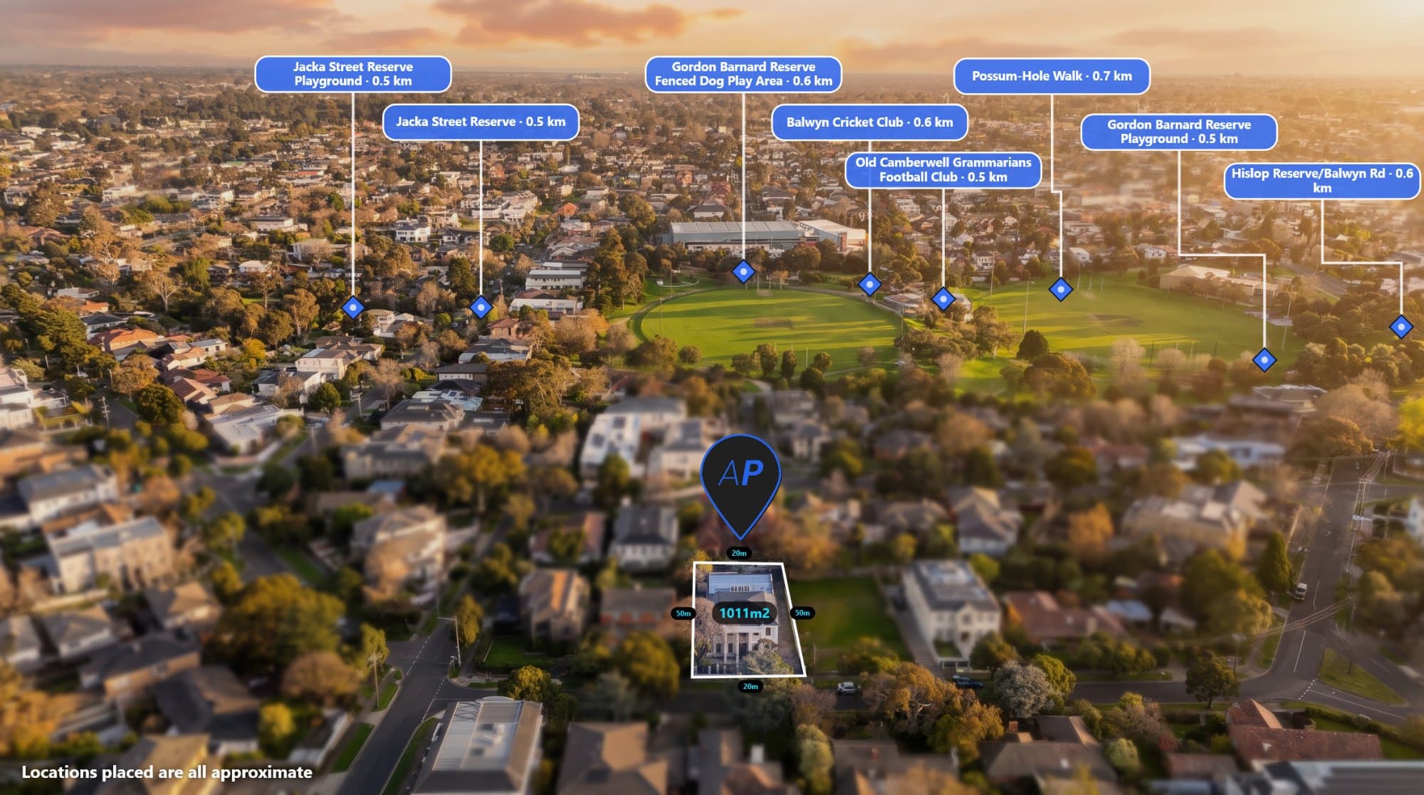
Drone photography has become an important part of real estate marketing, property development and land sales. A good aerial photo can show much more than the property itself, including nearby roads, parks, schools, shopping centres, boundaries and surrounding development.
The challenge is turning a raw drone image into a useful marketing image without spending a long time manually adding information.
AerialPin is a browser-based tool built specifically for annotating and editing aerial drone photos. It gives drone operators, real estate photographers and property professionals a way to add useful information directly to their images.
What is AerialPin?
AerialPin is an aerial photography annotation tool that lets you add locations, pins, boundaries, measurements, labels and other information to drone images.
Instead of switching between image editing software, maps and other tools, you can work with your aerial image in one place.
You can use AerialPin for:
- Real estate drone photography
- Property marketing
- Land development marketing
- New estate marketing
- Aerial property presentations
- Drone photography businesses
- Property listings
- Land sales
- Development site presentations
Add Location Pins to Drone Photos
One of the most useful features is the ability to add location pins to aerial images.
For example, a real estate agent might want to show the location of a nearby:
- School
- Train station
- Shopping centre
- Park
- Cafe
- Main road
- Beach
- Sporting facility
Rather than expecting someone to understand the location from the aerial image alone, you can visually identify important nearby places.
You can learn more about adding nearby locations to aerial photos with AerialPin.
AI Auto Place
Manually finding and placing multiple nearby locations can take time, especially when you're working with a large number of property photos.
AerialPin's AI Auto Place feature can help automate this process by using information from the aerial image and its available location and camera data to identify relevant places.
This can be particularly useful when preparing multiple property images for real estate marketing.
Learn more about AI Auto Place
Add Property Boundaries
Property boundaries can make an aerial image much easier to understand.
For development sites, vacant land and larger properties, you may want to show exactly which area is being marketed.
AerialPin allows you to add boundary overlays to your aerial images so viewers can quickly understand the property's footprint.
This can be useful for:
- Development sites
- Vacant land
- Acreage properties
- New residential estates
- Property subdivisions
- Land sales
Measure Distances
Aerial photos can also be useful for showing distances between a property and important locations.
For example, you could show the approximate distance from a property to a:
- Train station
- School
- Shopping centre
- Park
- Main road
- Beach
Adding measurements directly to an aerial image can make property marketing information easier to understand without requiring the viewer to open another application.
Add Text and Labels
Sometimes you simply need to point something out.
AerialPin includes tools for adding text and labels directly onto your drone images.
You can use labels to identify:
- Roads
- Buildings
- Lots
- Parks
- Development areas
- Property features
- Surrounding infrastructure
This is especially useful when creating marketing images for developers and real estate campaigns.
Work With GPS and EXIF Data
Many drone images contain GPS and camera information inside their EXIF metadata.
This information can include the image's latitude and longitude along with other camera information.
AerialPin can use this information to help place aerial images in their correct geographic context.
If you've edited a drone image and lost some of its GPS metadata, AerialPin also provides a tool for copying EXIF data from an original drone image.
AI Image Restyling
AerialPin also includes AI-powered image tools for changing the appearance of aerial photography.
The AI Restyle tool can be used to create different visual styles from an aerial image.
This can be useful when you want to create alternative versions of an image for different marketing campaigns or presentations.
AI Relight
Lighting can have a big impact on how a property looks in an aerial photograph.
AerialPin's AI Relight feature can create different lighting styles, including options such as:
- Bright day
- Golden hour
- Twilight
- Clear blue sky
The goal is to create a different visual presentation without needing to organise another drone flight.
360 Panorama Support
AerialPin also supports working with 360 aerial photography.
You can upload multiple drone photographs and stitch them together into a panorama.
Once the panorama has been created, you can view it using a 360 panorama viewer and add annotations to the image.
This can be useful for property developments, land marketing and projects where a standard aerial photograph doesn't provide enough context.
The 360 panorama functionality is currently in beta.
Why Use AerialPin for Drone Photography?
Traditional workflows can involve moving between several different applications.
You might use one application to edit the photograph, another to find nearby locations, another to measure distances and another to create maps or overlays.
AerialPin brings many of these aerial photography tasks into one browser-based workflow.
For drone operators and real estate photographers, this can mean less time spent manually preparing each image.
Who Is AerialPin For?
AerialPin is designed for anyone who regularly needs to add information to aerial photographs.
This includes:
Real Estate Photographers
Create more informative property images without manually building every annotation from scratch.
Drone Operators
Add locations, boundaries and measurements to images before delivering them to clients.
Real Estate Agents
Create aerial marketing images that show more of the surrounding area.
Property Developers
Highlight development sites, boundaries, nearby infrastructure and surrounding amenities.
Land Sellers
Use aerial photography to communicate the location and size of a property more clearly.
A Faster Way to Prepare Aerial Marketing Images
Aerial photography can provide a huge amount of information, but a raw drone image doesn't always communicate everything a potential buyer needs to know.
Adding locations, boundaries, measurements and labels can turn a standard aerial photograph into a much more informative marketing image.
AerialPin brings these tools together in one browser-based application, making it easier to prepare aerial images for real estate, property development and land marketing.