
AerialPin: The Drone Image Annotation Tool for Real Estate Photography
Looking for the best drone photography software for real estate? Learn how AerialPin combines aerial photo editing, drone image annotation, property lines and location markers in one simple workflow.
Real estate photography has moved well beyond taking a few photos of the front of a house.
Agents are using professional photography, video, floor plans and drone images to give buyers a better understanding of a property before they ever inspect it.
Drone photography is particularly useful because it shows the property from a completely different perspective. But a great aerial photograph can become even more useful when you add information directly to it.
That's where AerialPin comes in.
What Is AerialPin?
AerialPin is a drone image annotation tool built for property and real estate photography.
Instead of taking an aerial photo and then opening several different programs to edit, annotate and add location information, AerialPin brings those tools into one workflow.
You can use it to create:
- Property boundary lines
- Property labels
- Points of interest
- Distance markers
- Aerial annotations
- Property spotlights
- Custom pins
- Branded aerial marketing images
It's designed around a simple idea: make drone images more useful, not just more attractive.
Why Use Professional Photography for Real Estate?
The quality of your property photography can have a major impact on how a listing is presented.
Professional photography helps show the property at its best, while aerial photography adds another perspective that standard interior and exterior photographs can't provide.
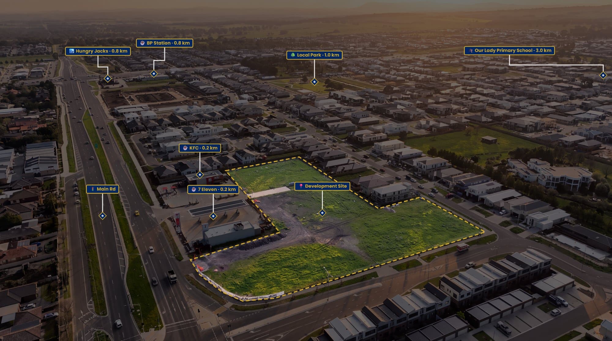
An aerial photograph can show the size of the block, backyard, driveway, surrounding streets and nearby amenities in a single image.
For larger properties, this can be particularly valuable.
A buyer looking at an acreage property, for example, may struggle to understand the size of the land from ground-level photographs alone.
Aerial photography puts the property into context.
How to Add Property Lines to Drone Images
One of the most common uses for aerial photo software is adding property boundaries.
From the air, property lines aren't always obvious.
A fence might be hidden by trees, neighbouring properties can look similar and large blocks can be difficult to distinguish.
With AerialPin, you can upload your drone image and create a property boundary directly over the photograph.
You can customise the appearance of the line, add a subtle fill or spotlight and label the property.
This creates a simple visual reference that helps the viewer understand which land belongs to the property.
If you're searching for how to add property lines to drone images, this is one of the easiest workflows to build into your real estate photography process.
Drone Image Annotation for Real Estate
Annotation doesn't have to mean covering your photograph with graphics.
Good aerial view image annotation should make the photograph easier to understand.
For example, you could add a boundary around the property and then mark:
Local Park — 450 m
Shopping Centre — 800 m
Train Station — 1.2 km
This gives buyers information about both the property and its location.
AerialPin's annotation tools are designed to let you build this information directly on top of the drone image.
Find Nearby Places From Your Drone Photo
AerialPin can also work with location information stored in compatible drone photographs.
GPS information from the drone can help identify where the photograph was taken, while camera information can help determine the direction the drone was facing.
This can be used to find nearby points of interest that may be visible within the photograph.
AerialPin AI Auto Place can then help position those locations on the image.
This is particularly useful for photographers who don't want to manually search for every nearby location and then work out where each marker should sit on an angled aerial photograph.
Real Estate Drone Editing
Real estate drone editing isn't always about changing the photograph itself.
Sometimes the best edit is adding useful information.
You might want to:
- Improve the exposure
- Correct colour
- Create a twilight version
- Add a property boundary
- Highlight the subject property
- Add nearby points of interest
- Add labels
- Create a branded aerial graphic
Traditional photo editing software can handle many of these tasks, but general-purpose programs aren't necessarily designed around real estate aerial photography.
That's where dedicated aerial photography software can make the workflow faster.
Is AerialPin the Best Photo Editing App for Real Estate?
There isn't one app that is automatically the best for every real estate photographer.
If you need detailed retouching, advanced colour grading or complex compositing, programs such as Photoshop and Lightroom are still powerful tools.
But if your focus is aerial property marketing and drone image annotation, a specialised tool can be much more convenient.
AerialPin focuses specifically on the things that make an aerial real estate image more informative:
Property boundaries.
Location markers.
Annotations.
Labels.
Aerial property marketing.
Instead of trying to make a general photo editor do everything, AerialPin is built around the aerial photography workflow.
What Makes Good Aerial Photo Software?
When choosing aerial photo software, there are a few things worth looking for.
Easy annotation
You should be able to add information without spending a long time manually positioning every element.
Property boundaries
If you're working in real estate, being able to create clean property outlines is extremely useful.
Location information
Being able to identify and display nearby points of interest can make aerial photographs much more valuable.
Consistent styling
If you're producing images for multiple agents, you want to be able to maintain a consistent visual style.
High-resolution exports
Aerial images used for property listings and marketing should remain sharp when exported.
Property Drone Photography Can Do More
Property drone photography doesn't have to be just a wide shot of the house.
Think about what the photograph can communicate.
Aerial photography can show the relationship between the home and the surrounding land.
Annotation can show the property boundary.
Location markers can show nearby amenities.
A spotlight can draw attention to the subject property.
Together, these elements can turn a simple location drone photo into a useful marketing asset.
Aerial Photography of My Property: What Should I Add?
If you're looking at your own aerial photography of a property and wondering what information to add, start with the basics.
First, make the property obvious.
Then consider what a buyer would want to know.
If it's a large block, show the boundary.
If it's close to a park, show the park.
If it's near transport or shopping, consider adding those locations.
Don't add information simply because you can. Every annotation should have a purpose.
The best aerial property images are usually the ones that communicate a lot without looking cluttered.
Aerial Photo Editing Services vs Doing It Yourself
Some real estate photographers choose to outsource their aerial photo editing services.
This can work well if you're dealing with a high volume of listings and don't want to spend time processing every image.
But for simple tasks such as property boundaries, labels and location annotations, having the right software can make it practical to handle the work yourself.
With AerialPin, you can create the annotations directly in your browser and keep the workflow in your own hands.
That means you can make changes whenever you need to, rather than sending an image back and forth to an editor.
A Better Workflow for Real Estate Aerial Images
A simple workflow could look like this:
Capture → Upload → Edit → Annotate → Add property boundary → Add locations → Export
You start with the original drone image and finish with a polished aerial marketing asset.
For photographers who regularly shoot properties, having this process in one place can save a significant amount of time.
Final Thoughts
Aerial photography gives real estate professionals a perspective that ground-level photography simply can't match.
But the photograph itself is only the starting point.
Adding property boundaries, locations and other useful annotations can help buyers understand the property much faster.
That's what AerialPin is built for.
It's a drone image annotation tool and aerial photography software platform designed to help real estate photographers turn ordinary drone photographs into informative property marketing images.
Whether you're looking for a better way to handle real estate drone editing, wondering how to add property lines to drone images, or simply want a faster way to annotate your aerial photography, AerialPin brings the workflow together in one place.
Try AerialPin and turn your next drone image into a better real estate marketing asset.