
AI Drone Photo Editing: A Faster Way to Edit Aerial Images
AI drone photo editing is changing how photographers prepare aerial images for real estate marketing. From changing the sky and lighting to automatically adding property boundaries and nearby locations, AI can turn a standard drone photo into a finished marketing visual much faster.
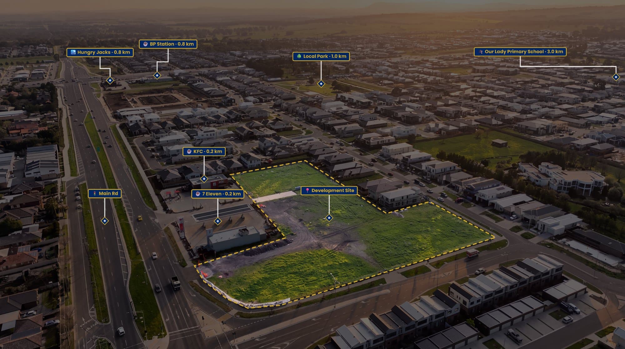
Drone photography has become a major part of real estate marketing, but capturing the image is only the beginning.
After the flight, there's still the editing.
You might need to correct the exposure, improve the sky, create a twilight version, add the property boundary and then find nearby schools, parks or shopping centres to include in the final image.
That's a lot of work for one photograph.
AI is starting to change that.
What Is AI Drone Photo Editing?
AI drone photo editing uses artificial intelligence to automate or simplify parts of the aerial photography editing process.
Instead of manually adjusting every part of an image, AI can analyse the photograph and make targeted changes based on what you're trying to achieve.
For real estate drone photography, this can include:
- Sky replacement
- Lighting changes
- Twilight effects
- Golden-hour effects
- Image enhancement
- Property annotations
- Nearby point-of-interest placement
- Automated labels
The biggest advantage is simple: less repetitive editing.
Turn a Daytime Drone Photo Into Twilight
One of the most useful applications is changing the lighting of an existing aerial photograph.
Maybe you photographed a property during the middle of the day but the agent wants a twilight image.
Normally, you'd need to capture the property again at the right time or spend significant time manually editing the photograph.
With AerialPin AI Relight, you can upload a drone JPEG or DNG and choose between looks such as bright day, golden hour, twilight and clear sky. The tool is designed to change the sky and lighting while keeping the photographed property and scene intact.
This means one drone flight can potentially give you multiple versions of the same aerial image.
AI Sky Replacement
The sky can completely change the feel of a drone photograph.
A flat, overcast sky can make an otherwise impressive property look dull.
AI can replace the sky and adjust the lighting on the scene to make the result feel more natural.
The important part is making sure the AI doesn't start changing the property itself.
For real estate marketing, the house, roof, driveway, landscaping and surrounding structures should remain accurate to the original photograph.
AI Property Annotation
AI isn't only useful for making drone photos look better.
It can also help make them more informative.
AerialPin is built around this part of the workflow, combining aerial photography with property annotation and location information. It can use data stored inside compatible drone images to help identify where the photograph was taken and what the camera was pointing towards.
That information can then be used to create marketing graphics directly on the aerial image.
Automatically Add Nearby Locations
Imagine uploading a drone photo and having the software work out which nearby schools, parks and shopping centres could actually be visible in the shot.
That's the idea behind AerialPin AI Auto Place.
It reads GPS position, altitude, compass heading and gimbal angle from the drone photograph, then calculates which nearby places can appear within the camera's field of view and places the pins automatically.
You can then review the result and adjust anything before exporting.
This can remove one of the most repetitive parts of creating annotated aerial property images.
Add Property Boundaries
Property boundaries are another useful addition to aerial real estate photography.
From above, it isn't always obvious where a property starts and ends.
AerialPin lets you trace the block directly over the drone image and customise the boundary with different fills, strokes and spotlight effects. It can also calculate edge lengths and the enclosed area as you build the boundary.
For large blocks, acreage, vacant land and development sites, this can make the aerial photograph considerably easier to understand.
Of course, boundary overlays should be based on appropriate property information and shouldn't be presented as a legal survey unless they are supported by authoritative survey data.
AI Doesn't Have to Replace Your Existing Editing Software
AI drone editing doesn't necessarily mean throwing away Lightroom or Photoshop.
In fact, a combination can make more sense.
Lightroom can handle your RAW processing, exposure and colour.
Photoshop can handle detailed retouching and advanced composites.
AerialPin can handle aerial-specific tasks such as property boundaries, points of interest, labels and AI-assisted placement.
This lets you use the right tool for each part of the workflow.
Create Consistent Marketing Images
Another benefit of using dedicated aerial software is consistency.
If you're a real estate photographer working with several agencies, you may want every aerial image to follow the same visual style.
AerialPin's Styles feature lets you customise pin shapes, colours, typography, boundary lines, leader lines and spacing, then save those settings as a reusable template.
So instead of manually recreating your design for every property, you can apply the same style again and again.
From Drone Photo to Finished Marketing Visual
A traditional workflow might look like:
Capture → Edit → Google Maps → Photoshop → Draw boundaries → Add labels → Position pins → Export
An AI-assisted workflow can be much simpler:
Capture → AI Edit → AerialPin → Auto Place → Boundary → Export
The photographer still controls the final image, but much of the repetitive work happens automatically.
Why AI Drone Editing Matters for Real Estate Photographers
Real estate photographers are expected to produce more content than ever.
A single property might require:
- Interior photography
- Exterior photography
- Drone photography
- Video
- Social media content
- Floor plans
- Twilight imagery
- Location graphics
AI can help photographers get more out of the content they're already capturing.
Instead of spending another 30 minutes manually building an aerial graphic, you can use that time to photograph another property, edit another listing or focus on your clients.
The Future of Aerial Photography
AI drone photo editing is moving aerial photography beyond simple colour correction.
The software can now understand information contained within the photograph and use it to create new versions and marketing assets.
For real estate, that means a single aerial photograph can become:
A daytime hero image
A twilight version
A property boundary graphic
A location map
A nearby amenities visual
All from the same original flight.
That's what makes AI particularly interesting for professional drone photographers.
It's not just about making photographs look better.
It's about making the entire aerial photography workflow faster.
If you're looking for an AI drone photo editing tool built specifically around real estate aerial imagery, AerialPin combines AI Relight, AI Auto Place, property boundaries, annotations and aerial marketing tools in one browser-based workflow.
Capture once. Edit with AI. Create more from every drone photo.