
Automated Drone Photo Editing Software for Real Estate
Automated drone photo editing software can take repetitive work out of real estate aerial photography. From AI relighting and sky changes to automatic property annotations and nearby points of interest, tools like AerialPin help photographers turn drone images into finished marketing visuals faster.
Real estate photographers already have enough to edit.
After a property shoot, there might be hundreds of photos to sort, colour-correct and export. Then there's video, floor plans, social media content and, increasingly, aerial photography.
The last thing you want is to spend another 20 minutes manually drawing lines and placing labels on every drone image.
That's where automated drone photo editing software comes in.
What Can Be Automated?
Modern drone editing software can automate different parts of the workflow depending on what you're trying to achieve.
For real estate, that can include:
- Colour and exposure adjustments
- Sky replacement
- Twilight and golden-hour effects
- Property boundary annotation
- Nearby point-of-interest searches
- Automatic pin placement
- Labels and location markers
- Consistent annotation styles
- Batch exports
The idea isn't to remove the photographer from the process.
It's to remove the repetitive work.
AI Editing for Aerial Photos
AI is particularly useful when the original photograph is good, but the conditions aren't ideal.
For example, you might capture an incredible property but have a dull overcast sky.
Instead of waiting for another day, AI editing can change the lighting and atmosphere.
AerialPin AI Relight can create different looks from the same aerial photograph, including bright day, golden hour, twilight and clear-sky versions. The tool is designed to change the sky and lighting while keeping the existing property and scene intact.
That can be particularly useful when you're trying to create premium real estate marketing imagery from a single drone flight.
Automatically Annotate Drone Photos
Editing the photograph is only one part of real estate aerial photography.
The other part is adding information.
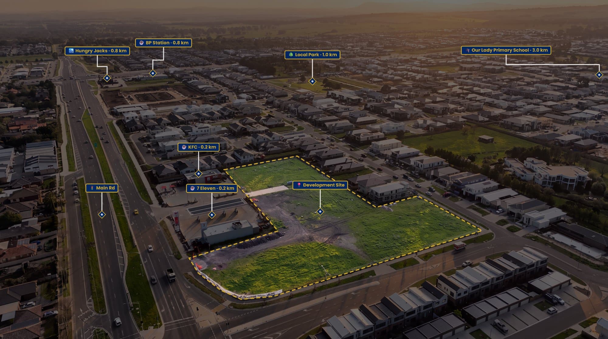
A property boundary can show buyers exactly which block is being marketed. Nearby schools, parks, shopping centres and transport can give them a better understanding of the location.
Traditionally, this meant searching for locations, taking screenshots, drawing lines and manually positioning every label.
Automation can make that much quicker.
AerialPin is designed specifically for this type of aerial workflow. It can read information from compatible drone photos and use it to help create professional property annotations.
AI Auto Place
One of the more repetitive parts of drone annotation is deciding where each nearby location should go.
AerialPin's AI Auto Place uses GPS position, altitude, compass heading and gimbal angle stored in the drone photograph to work out which nearby places can actually be visible from the camera's position. It then places the relevant pins onto the image.
You can review the result afterwards and move, rename or remove anything you don't want.
That makes the process much faster than manually positioning every marker.
Property Boundaries Still Matter
Automation doesn't mean you have to sacrifice control.
AerialPin lets photographers draw property boundaries directly over their aerial photographs, with adjustable fills, strokes and spotlights. It can also calculate edge lengths and the enclosed area as the boundary is created.
This is useful for:
Acreage properties
Development sites
Vacant land
Large residential blocks
Properties where the boundary isn't obvious from the photograph
The finished boundary should still be treated as a marketing visual unless it has been created from appropriate official or survey information.
Create a Consistent Look Automatically
If you're producing aerial images for multiple agents, consistency becomes important.
You don't want every property to have a different font, pin style or boundary design.
AerialPin's Styles feature lets photographers create reusable templates controlling things such as typography, pin appearance, colours, boundary lines and leader lines.
Create the style once, then reuse it across your next listings.
This is especially useful for photographers who want their aerial marketing visuals to become part of their brand.
Automated Drone Editing Doesn't Replace Lightroom or Photoshop
You don't necessarily need to replace your existing editing software.
A professional workflow can use different tools for different jobs.
Lightroom: colour, exposure and RAW processing.
Photoshop: detailed retouching and complex edits.
AerialPin: aerial annotations, property boundaries, locations and AI-powered aerial workflows.
There are also dedicated AI editors focused on photographic corrections. For example, Imagen offers AI editing for real estate drone photography, including sky replacement and other automated adjustments.
The best setup depends on how much of your workflow you want to automate.
From Drone Photo to Marketing Visual
The biggest advantage of automation is that it changes what you can do with the same photograph.
Instead of:
Drone photo → Basic edit → Export
you can create:
Drone photo → AI edit → Property boundary → Nearby locations → Branding → Finished marketing visual
And the photographer still controls the final result.
That's important.
Automation should make the first version faster, not force you to accept whatever the software produces.
A Faster Real Estate Drone Workflow
For a real estate photographer, a modern workflow could look something like this:
1. Capture
Take the aerial photographs with your DJI drone.
2. Select
Choose the strongest images from the shoot.
3. Enhance
Correct exposure and colour, or create an AI-relit version.
4. Annotate
Open the image in AerialPin and add the property boundary and relevant locations.
5. Automate
Use AI Auto Place to position nearby points of interest.
6. Style
Apply your saved annotation template.
7. Export
Create the finished high-resolution marketing image.
The photographer still makes the creative decisions. The software simply handles more of the repetitive work.
Why This Matters for Real Estate Photographers
Real estate photographers are being asked to provide more content than ever.
Aerial photography is no longer just about taking an impressive photo from above.
The same image can become a location graphic, property boundary visual, social media asset or part of a larger marketing campaign.
Automation makes it possible to create these additional assets without adding the same amount of manual editing time.
That's the real value of automated drone photo editing software.
You capture the image once. Your software helps you get more from it.
Final Thoughts
AI and automation are changing aerial photography, particularly for real estate.
Photographers can now automate everything from lighting adjustments to property annotations and location-based graphics.
For photographers who regularly create aerial property marketing images, AerialPin brings several of these workflows together, including AI Relight, AI Auto Place, property boundaries, nearby places and reusable annotation styles.
The result is a simpler workflow and, more importantly, more useful aerial images for real estate clients.
Capture better. Edit faster. Annotate automatically.