
Best Aerial Photo Annotation Software for Real Estate Photographers (2026)
Compare the best aerial photo annotation software for real estate photographers. Discover why AerialPin is the fastest way to annotate DJI drone images with property boundaries and nearby amenities.
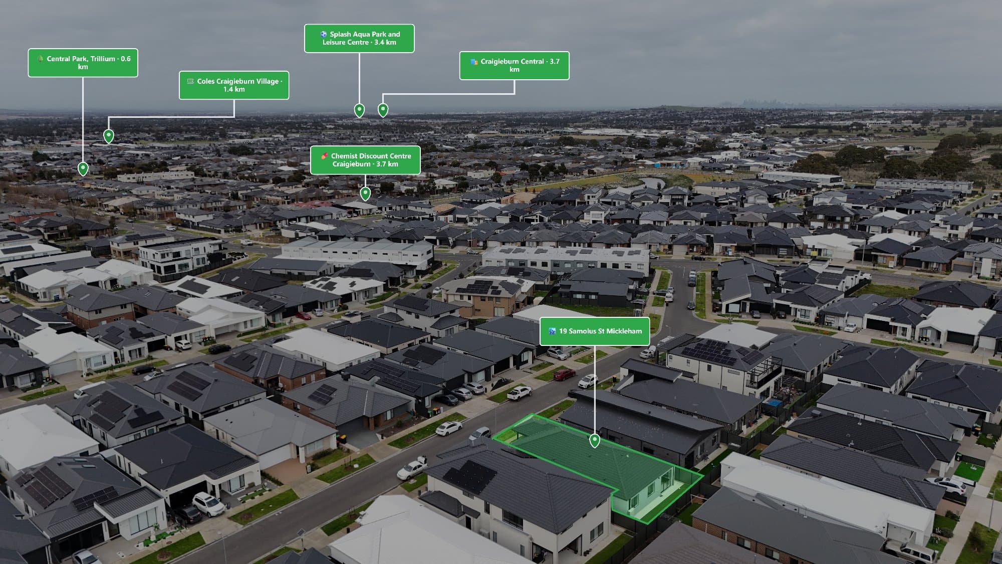
Best Aerial Photo Annotation Software for Real Estate Photographers (2026)
If you're a real estate photographer, you've probably spent hours inside Photoshop adding nearby amenities, drawing property boundaries, positioning labels, and creating polished aerial images for clients.
While the end result looks great, the editing process can be incredibly time-consuming.
Fortunately, dedicated aerial photo annotation software is making this workflow much faster.
Instead of manually creating every label and line, photographers can now automate much of the process and deliver professional aerial marketing images in a fraction of the time.
Here's what to look for when choosing the best aerial photo annotation software.
Why Annotate Aerial Drone Photos?
Drone photography tells buyers where a property is.
Annotations tell them why it matters.
By adding nearby schools, shopping centres, transport links, parks, landmarks, and property boundaries, an aerial image becomes significantly more valuable.
Annotated aerial photos help:
- Increase buyer engagement
- Highlight key selling points
- Showcase nearby amenities
- Explain property boundaries
- Make listings easier to understand
- Improve brochure and social media marketing
For agents, annotated images help properties stand out.
For photographers, they become an additional premium service.
What Makes Great Annotation Software?
Not all software is designed specifically for real estate photography.
The best solutions should include:
Automatic Nearby Amenity Search
Instead of manually finding every school or shopping centre, good software should automatically locate nearby points of interest.
Examples include:
- Schools
- Parks
- Shopping centres
- Train stations
- Beaches
- Medical centres
- Sporting facilities
Easy Property Boundary Drawing
One of the most requested edits from real estate agents is outlining property boundaries.
Good annotation software should make this process quick and accurate with simple drawing tools.
Professional Labels
Labels should look clean, modern, and consistent.
You should be able to customise:
- Fonts
- Colours
- Icons
- Leader lines
- Positioning
Professional branding makes a significant difference when delivering images to clients.
Batch Editing
If you're editing dozens of drone photos every week, batch workflows save hours.
The ability to reuse templates and export multiple images quickly is essential.
High-Resolution Export
Your software should export print-quality images suitable for:
- Real estate portals
- Brochures
- Signboards
- Social media
- Large format printing
Why Many Photographers Are Choosing AerialPin
One platform that's gaining attention among real estate photographers is AerialPin.
Unlike general graphic design software, AerialPin has been built specifically for aerial real estate photography.
Its goal is simple:
Reduce editing time while creating professional-looking aerial marketing images.
Some of its key features include:
- Automatic nearby point of interest search
- Property boundary tools
- Professional annotation labels
- Custom branding presets
- Batch image exporting
- JPEG support
- DJI DNG support
- Fast browser-based workflow
- No complex Photoshop editing required
Rather than switching between Google Maps, Photoshop, Illustrator, and multiple plugins, photographers can complete the entire annotation workflow in one place.
Photoshop vs AerialPin
| Feature | Photoshop | AerialPin |
|---|---|---|
| Nearby amenity search | ❌ Manual | ✅ Automatic |
| Property boundaries | ⚠ Manual | ✅ Built-in |
| Professional labels | ⚠ Manual | ✅ Built-in |
| Branding templates | ⚠ Manual | ✅ Saved presets |
| Batch exports | ❌ Limited | ✅ Designed for workflow |
| DJI DNG support | ⚠ Requires editing | ✅ Supported |
| Built for real estate | ❌ General editor | ✅ Yes |
Photoshop remains an incredibly powerful editing tool.
However, for aerial annotations specifically, dedicated software like AerialPin dramatically reduces production time.
Who Is AerialPin For?
AerialPin is designed for professionals including:
- Real estate photographers
- Drone operators
- Property marketing agencies
- Builders
- Developers
- Real estate agencies
Whether you're producing five listings a week or hundreds each month, streamlining aerial annotations can save countless hours.
The Future of Aerial Photo Editing
As AI and automation continue to evolve, aerial annotation is becoming faster and more intelligent.
Photographers increasingly expect software to:
- Detect nearby landmarks automatically
- Create consistent branding
- Export multiple image formats
- Reduce repetitive editing tasks
Purpose-built platforms are replacing manual workflows, allowing photographers to focus more on capturing great images and less on editing them.
Final Thoughts
Creating annotated aerial images shouldn't require hours in Photoshop.
Modern annotation software is helping photographers work faster, deliver better-looking images, and offer more value to real estate clients.
If you're looking for software built specifically for real estate drone photography, AerialPin is worth exploring.
From automatic nearby amenity searches to property boundary tools and professional export templates, AerialPin helps turn ordinary drone photos into premium marketing assets in minutes.
Learn More
Ready to speed up your aerial editing workflow?
👉 Visit https://aerialpin.com to see how AerialPin helps real estate photographers annotate drone images faster and create professional marketing visuals with ease.