
Best Drone Editing Software for Real Estate
Looking for the best drone editing software for real estate? Compare the tools photographers use to edit aerial images, add property boundaries, highlight nearby locations and create professional marketing visuals with AerialPin.
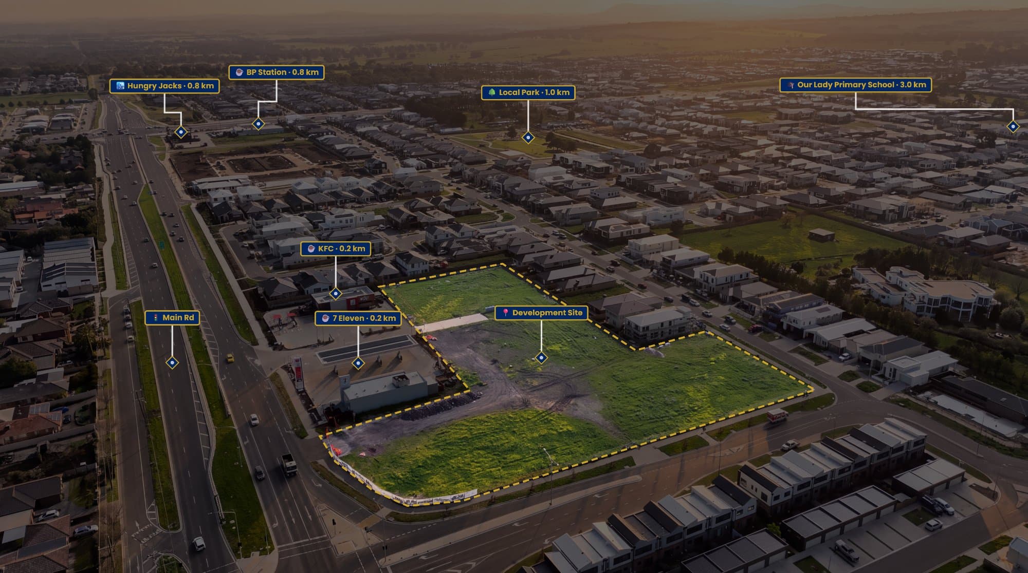
Real estate drone photography has become a standard part of property marketing.
A good aerial image can show the home, backyard, block size, surrounding streets and nearby amenities in one shot. But taking the photo is only half the job.
The editing that comes afterwards can turn a basic drone image into something much more useful for a property listing.
If you're looking for the best drone editing software for real estate, the right choice depends on what you're trying to do with your images.
What Should Real Estate Drone Editing Software Do?
A general photo editor can handle exposure, colour, contrast and retouching.
But real estate drone photography often needs something more.
You may want to add a property boundary, highlight the block, show nearby schools and parks, add labels or create a branded aerial marketing graphic.
That's where specialised aerial photography software can be useful.
A good workflow should make it easy to:
- Edit the original aerial photograph
- Add property boundaries
- Add points of interest
- Create labels and markers
- Highlight the subject property
- Maintain consistent branding
- Export high-resolution images
The goal is to spend less time building graphics and more time delivering finished marketing content.
Lightroom: Best for Traditional Photo Editing
Adobe Lightroom remains one of the strongest options for the actual photographic side of drone editing.
It's useful for correcting:
- Exposure
- White balance
- Highlights
- Shadows
- Contrast
- Colour
- Sharpness
If you're processing RAW or DNG files from a DJI drone, Lightroom gives you plenty of control over the final image.
For photographers who already use Lightroom for their real estate work, it makes sense to keep using it for the core photo edit.
But Lightroom isn't designed specifically for property annotation.
That's where another tool can complement your workflow.
Photoshop: Best for Advanced Editing
Photoshop is still difficult to beat when you need complete control over an image.
You can remove objects, replace skies, create composites, add graphics and make detailed retouching adjustments.
It's also possible to draw property boundaries and create aerial marketing graphics in Photoshop.
The downside is the amount of manual work involved.
If you're drawing boundaries, searching for nearby locations and positioning labels on dozens of aerial photographs, Photoshop can become a slow way of doing something relatively simple.
AerialPin: Best for Drone Image Annotation
AerialPin takes a different approach.
Rather than trying to replace Lightroom or Photoshop as a general photo editor, it's built around the aerial property annotation workflow.
You can upload a drone image and create property boundaries, labels, points of interest and other visual information directly over the photograph.
This makes it particularly useful for real estate photographers who already have their preferred photo-editing software but need a faster way to turn the finished aerial image into a marketing graphic.
Property Boundaries Without Building Everything From Scratch
One of the most common uses for AerialPin is adding property boundaries.
From a drone, it isn't always obvious where one property ends and another begins.
AerialPin lets you click points directly onto the aerial photograph to create the boundary. You can adjust the fill, stroke and spotlight, while the software can also calculate edge lengths and total area.
This can be especially useful for:
Acreage properties
Large residential blocks
Development sites
Vacant land
Properties with unclear boundaries
The important thing is to use reliable property information and treat the finished graphic as a marketing visual rather than automatically presenting it as a legal survey.
Add Nearby Places to Your Drone Photos
Aerial images can also tell buyers more about the location.
Instead of simply showing the house, you can highlight nearby:
- Schools
- Parks
- Shopping centres
- Train stations
- Beaches
- Sporting facilities
- Major roads
AerialPin can pull nearby points of interest and let you place them directly onto the aerial photograph.
This changes the purpose of the photograph.
It's no longer just an attractive view of the property. It becomes a visual explanation of where the property is and what's around it.
AI Auto Place Makes Annotation Faster
Manually positioning every point of interest can take time, especially with angled drone photography.
AerialPin AI Auto Place uses GPS position, altitude, compass heading and gimbal angle stored in compatible drone photographs to work out which nearby places are visible and position the pins on the image.
You can then review the result, move anything that needs adjusting and export the finished image.
For photographers processing multiple listings, removing this repetitive positioning work can make a noticeable difference to the workflow.
Keep Your Aerial Images Consistent
If you're creating images for different agents, consistency matters.
You don't want one listing to have tiny labels, another to have huge pins and another to use completely different colours.
AerialPin's Styles tools let you customise pin shapes, colours, typography, boundary lines, leader lines and spacing. Styles can then be saved as reusable templates.
That means you can create a look once and use it across future property listings.
For agencies and photographers working at higher volumes, this can help make every aerial image feel like part of the same brand.
So, What Is the Best Drone Editing Software for Real Estate?
There isn't one piece of software that does everything perfectly.
For many photographers, the best workflow is actually a combination of tools.
Lightroom for RAW processing and colour correction.
Photoshop for advanced retouching and complex image editing.
AerialPin for property boundaries, aerial annotations, points of interest and location-based marketing graphics.
This approach lets each tool do what it's good at instead of forcing one application to handle the entire process.
Why AerialPin Is Different
The biggest difference is that AerialPin isn't trying to be another general-purpose photo editor.
It's focused on a specific problem faced by real estate photographers: turning aerial photographs into informative property marketing visuals.
The platform supports JPEG and DJI DNG aerial images and includes tools for property boundaries, nearby places, AI-assisted pin placement, annotation styles and batch exports.
That makes it particularly useful when you're producing aerial property images regularly and don't want to manually recreate the same graphics for every listing.
A Better Real Estate Drone Editing Workflow
A simple workflow could look like this:
1. Capture the drone photo
Get the best possible aerial image in-camera.
2. Edit the photograph
Use Lightroom or your preferred editor to correct exposure, colour and overall image quality.
3. Open the finished image in AerialPin
Add the information that makes the photograph more useful.
4. Add the property boundary
Outline the block and adjust the visual style.
5. Add nearby locations
Highlight the schools, parks, shopping and other locations that matter.
6. Apply your style
Use a saved template to keep your aerial marketing images consistent.
7. Export
Deliver the finished image to the agent for the listing, brochure or social media campaign.
Final Thoughts
The best drone editing software for real estate depends on the job you're trying to complete.
If you need traditional photo editing, Lightroom and Photoshop are excellent choices.
But if you're looking for drone image annotation software specifically for real estate, AerialPin is built around that workflow.
It helps photographers take the aerial images they're already capturing and turn them into more informative marketing assets with property boundaries, location markers, labels and professional styling.
For real estate photographers, that's often the difference between simply delivering a drone photo and delivering a marketing image that actually tells a story.
Try AerialPin and turn your next aerial property photo into a professional real estate marketing visual.