
Best Drone Mapping Tools for Real Estate Photos
Drone mapping tools can help real estate professionals turn aerial photography into useful property marketing material. From location pins and measurements to property boundaries and nearby points of interest, learn what to look for in a drone mapping workflow.
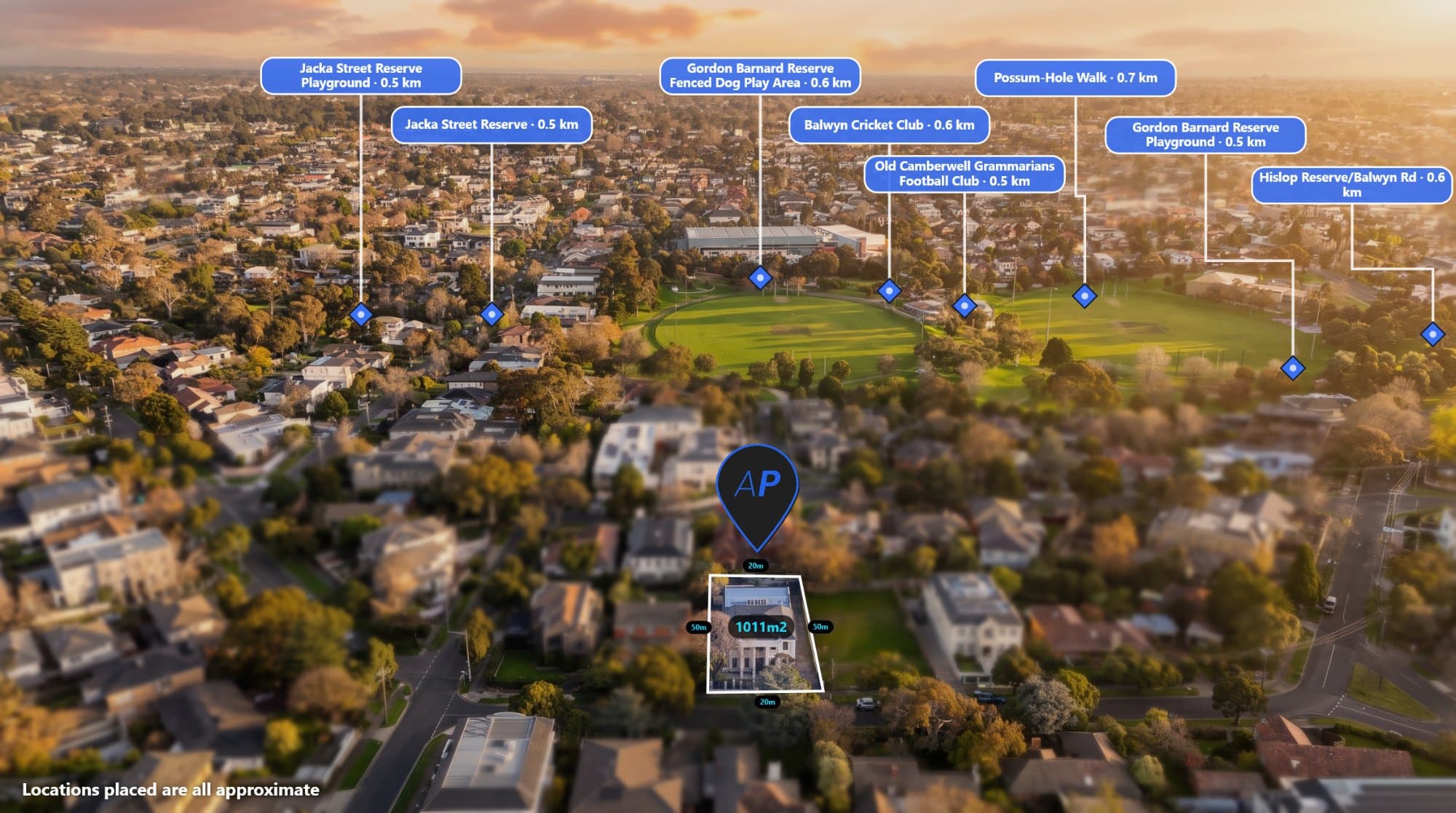
Drone photography has become a common part of real estate marketing. A single aerial image can show the property, surrounding streets, nearby parks, neighbouring properties and the wider area.
But sometimes a raw drone photo isn't enough.
Real estate agents, drone operators and property developers often need to add information to the image, such as location pins, distances, property boundaries and labels.
That's where drone mapping tools for real estate can help.
What Are Drone Mapping Tools for Real Estate?
Drone mapping tools are software platforms that help you work with aerial photography and geographic information.
Depending on the software, you may be able to:
- View aerial imagery
- Add location markers
- Measure distances
- Add property boundaries
- Label nearby locations
- Work with GPS and EXIF data
- Create property marketing graphics
- Process multiple aerial images
- Create 360 panoramas
Not every drone mapping tool is designed for the same job.
Some are focused on surveying and GIS. Others are designed for photogrammetry and 3D modelling. For real estate marketing, you may simply need a fast way to turn a drone photograph into an informative marketing image.
What Should You Look for in a Real Estate Drone Mapping Tool?
The right tool depends on what you're trying to create.
For property marketing, useful features include:
Location Pins
Location pins make it easy to highlight nearby points of interest.
You might want to show:
- Schools
- Parks
- Shops
- Train stations
- Main roads
- Beaches
- Sporting facilities
The ability to search for nearby locations can save time compared with manually finding every location.
Distance Measurements
Distance labels can show how far the property is from nearby locations.
For example:
400 m to park
800 m to shops
1.2 km to school
These measurements can make an aerial marketing image much easier to understand.
Property Boundaries
Property boundaries can be useful when marketing land, development sites, acreage properties and large blocks.
A boundary overlay can show viewers exactly which area the image is referring to.
However, it's important to use appropriate cadastral or survey data when accuracy matters. Drone GPS information alone should not be treated as a legal property boundary.
Text and Labels
Simple text tools are useful for adding information directly to the aerial photo.
You can label roads, buildings, development areas, access points and other features.
GPS and EXIF Support
Many drones record GPS information inside the image's EXIF metadata.
A tool that can read this information can help place the photograph in its geographic context.
You can inspect drone metadata with AerialPin's EXIF tools.
AerialPin for Real Estate Drone Photography
AerialPin is a browser-based aerial photo annotation tool designed around real estate and property photography.
Instead of using a general image editor to manually create every annotation, you can upload your drone photo and add information directly to the image.
You can add:
- Location pins
- Nearby locations
- Distance measurements
- Property boundaries
- Text labels
- Custom pins
- Other aerial photo annotations
This makes it useful for real estate photographers and drone operators who regularly create property marketing images.
Find Nearby Locations Automatically
One of the time-consuming parts of creating an aerial marketing graphic is finding relevant nearby locations.
You might need to search for a park, school, shopping centre or train station and then manually place each one on your image.
AerialPin Nearby Search helps find nearby places that can be used when annotating an aerial photograph.
There is also AI Auto Place, which can use the drone image's GPS and camera information along with nearby places to help automatically place relevant locations.
You can review the results rather than manually building every annotation from scratch.
Drone Mapping for Property Developers
Drone mapping tools aren't only useful for residential listings.
Property developers can use annotated aerial images to communicate information about development sites.
For example, an aerial image could show:
SITE BOUNDARY
ACCESS ROAD
PROPOSED LOTS
EXISTING HOMES
PARK
FUTURE DEVELOPMENT
This gives buyers, investors and other stakeholders a visual understanding of the site and its surroundings.
Drone Mapping for Land Sales
Large blocks of land can be difficult to explain using standard property photos.
An aerial photograph can show the full property and surrounding area, while annotations can provide additional context.
You could highlight:
- Property boundaries
- Roads
- Nearby towns
- Waterways
- Parks
- Access points
- Development areas
- Distances to important locations
This is particularly useful when the property is too large to understand from ground-level photography alone.
360 Panoramas for Real Estate
Some drone workflows go beyond standard aerial photography.
360 panoramas can provide a wider view of a property and its surroundings.
AerialPin also has a 360 panorama feature currently in beta. You can upload multiple drone images, stitch them into a panorama and view the result in a 360 panorama viewer.
The panorama can then be annotated with information directly within the workflow.
This can be useful for property marketing where showing the wider environment is important.
Do You Need Professional GIS Software?
Not necessarily.
Professional GIS and mapping platforms can be extremely powerful, but they can also be more complicated than what a real estate photographer needs.
If your goal is simply to create an annotated aerial marketing image, a specialised browser-based tool can be a much simpler workflow.
The important question is what you actually need to accomplish.
If you're performing surveying, engineering, detailed GIS analysis or photogrammetry, you'll likely need more specialised software.
If you're creating property marketing graphics, you may only need the ability to annotate aerial photography quickly.
Drone Mapping vs Photo Annotation
These terms can sometimes overlap, but they're not exactly the same.
Drone mapping can involve collecting geographic data, creating maps, processing imagery and analysing locations.
Aerial photo annotation is more focused on adding useful information to an existing photograph.
For real estate marketing, annotation is often the final step that turns a drone photograph into a marketing graphic.
You might already have the drone image. What you need is a fast way to add the information buyers need to see.
Keep Your Aerial Images Simple
More annotations don't necessarily make a better marketing image.
If you add too many pins, lines and labels, the photograph can become difficult to understand.
Focus on the information that matters most.
For a residential property, that might be:
- The property boundary
- One nearby park
- A school
- Shopping
- A major road
For a large development site, you may need considerably more information.
The goal is to add context without hiding the aerial photograph itself.
Choosing a Drone Mapping Workflow
When comparing drone mapping tools for real estate, consider how much work you actually want to do manually.
Look for a workflow that makes it easy to:
- Upload your aerial image
- Identify the property's location
- Find nearby locations
- Add pins and labels
- Add measurements
- Add boundaries
- Review the finished image
- Export the final graphic
A simple workflow can be more practical than using several different applications for each step.
Final Thoughts
Drone mapping tools for real estate can help turn standard aerial photography into more informative property marketing.
For agents, photographers, drone operators and developers, features such as location pins, measurements, boundaries, labels and GPS support can make it much easier to communicate what's around a property.
AerialPin brings these aerial photo annotation tools together in a browser-based workflow, with AI-assisted location placement and 360 panorama support also available in the platform.