
Best Software for Annotating Drone Photos
Choosing the right drone photo annotation software can make it much easier to add locations, property boundaries, measurements and labels to aerial images. This guide looks at what to consider when choosing annotation software and how AerialPin fits into a modern drone photography workflow.
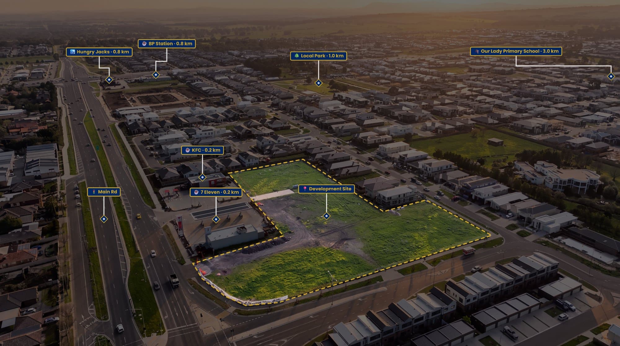
Drone photography is widely used for real estate marketing, property development, land sales and aerial inspections. But capturing the image is only part of the workflow.
In many cases, the aerial photo needs additional information before it is ready to send to a client or use in marketing.
Location pins, property boundaries, measurements and labels can turn a standard drone photograph into a much more informative image.
That's where drone photo annotation software comes in.
What Is Drone Photo Annotation Software?
Drone photo annotation software allows you to add information directly to an aerial photograph.
Depending on the software, you may be able to add:
- Location pins
- Points of interest
- Property boundaries
- Distance measurements
- Text labels
- Roads and landmarks
- Development areas
- Custom annotations
For real estate photographers and drone operators, this can save time compared with manually creating annotations using several different applications.
What Should You Look for in Drone Photo Annotation Software?
Not every image editor is designed for aerial photography.
When choosing a tool, look for features that match your workflow.
Location Pins
The ability to add nearby locations is useful for real estate and property marketing.
You might want to show a nearby school, shopping centre, park, train station or major road.
AerialPin includes Nearby Search, allowing you to find nearby places and add them to an aerial image.
Property Boundaries
If you're working with development sites, vacant land or acreage properties, property boundaries can be one of the most important annotations.
A good annotation tool should make it easy to clearly show the area being marketed.
Distance Measurements
Distance labels can provide additional context to an aerial image.
For example, you could show the approximate distance between a property and a nearby train station or shopping centre.
This can be particularly useful for real estate marketing.
Text and Labels
Simple text labels are useful when you need to identify something that isn't automatically detected.
AerialPin lets you add text and labels directly to your aerial photographs.
GPS and EXIF Support
Drone images often contain useful GPS information in their EXIF metadata.
Software that can work with this information can make location-based annotation much easier.
AerialPin can use the geographic information contained in compatible drone photographs to help position your image correctly.
AerialPin for Drone Photo Annotation
AerialPin is a browser-based tool built specifically around aerial photography and property marketing.
Instead of treating a drone photo like a normal image, it combines image annotation with location-based tools.
You can use it to add:
- Nearby locations
- Location pins
- Property boundaries
- Measurements
- Text labels
- AI-generated placements
- AI image effects
- 360 panorama annotations
AI Auto Place for Drone Photos
One feature that can save time is AI Auto Place.
Rather than manually placing every location, the tool can help identify relevant places from the available image and geographic information.
This is useful when you regularly create annotated property photographs and don't want to repeat the same manual process for every image.
AI Tools for Aerial Photography
Some drone photo workflows also involve creating different versions of an image for marketing.
AerialPin includes AI Relight, which can create different lighting looks such as bright day, golden hour and twilight.
You can also use AI Restyle to create alternative visual treatments.
These tools are separate from annotation but can be useful when preparing a complete aerial marketing image.
360 Panorama Annotation
If you work with panoramic drone photography, another feature to consider is 360 support.
AerialPin can stitch multiple photographs into a 360 panorama and lets you view and annotate the resulting panorama.
This can be useful for property developments and larger sites where a single aerial photograph doesn't provide the full picture.
The 360 panorama functionality is currently in beta.
Desktop Software vs Browser-Based Tools
Traditional desktop applications can be powerful, but they can also require a more complicated workflow.
You may need to:
- Edit the drone photograph
- Find nearby locations separately
- Create a map or boundary
- Export the information
- Combine everything into a final image
A browser-based aerial annotation tool can bring more of these steps into one workflow.
This doesn't mean desktop image editors are no longer useful. Photoshop and similar applications remain useful for detailed image editing.
The difference is that dedicated aerial annotation software focuses specifically on the information commonly added to drone photographs.
Drone Annotation Software for Real Estate
Real estate photographers often need to create aerial images that communicate location as well as appearance.
For example, an annotated aerial photograph could show:
Property → School → Shopping Centre → Train Station → Park
This provides useful context without requiring the viewer to work everything out themselves.
For photographers delivering multiple property campaigns, having a repeatable annotation workflow can also make the process more efficient.
Drone Annotation Software for Developers
Property developers have similar requirements, particularly when marketing land or development projects.
Annotations can help communicate:
- Site boundaries
- Surrounding infrastructure
- Nearby developments
- Roads
- Parks
- Transport
- Commercial areas
Aerial images can therefore be used as more than just photography. They can become visual marketing and communication tools.
Which Features Matter Most?
The right software depends on what you're trying to create.
If you only need basic arrows and text, a general image editor may be enough.
If you're regularly working with property aerial photography, you may benefit from software that combines:
- Aerial image annotation
- Location search
- GPS information
- Property boundaries
- Measurements
- AI tools
- 360 panorama support
AerialPin is designed around this type of workflow.
Start Annotating Drone Photos
The best drone photo annotation workflow is one that makes it easy to turn a raw aerial photograph into a useful final image.
For real estate photographers, drone operators, developers and property marketers, tools such as location pins, boundaries, measurements and labels can add significantly more context to an aerial photograph.
AerialPin brings these features together in a browser-based workflow designed specifically for aerial photography.
You can try AerialPin and start annotating your drone photos online.