
Best Software to Add Points of Interest to Drone Photos
Looking for the best software to add points of interest to drone photos? Compare the top tools for creating professional real estate aerial images with nearby schools, parks, transport, shopping centres, and other important landmarks. Find out which software saves the most time and delivers the best results.
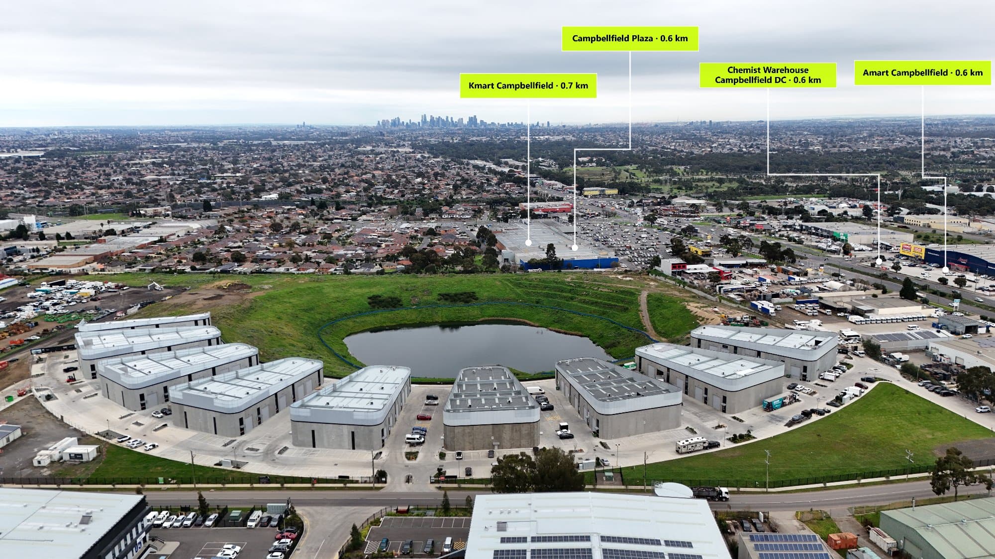
Drone photography has become an important part of modern real estate marketing, but adding Points of Interest (POIs) can make aerial images even more valuable for buyers.
By showing nearby schools, parks, shopping centres, train stations, cafés, and other landmarks, buyers can quickly understand the lifestyle and location benefits of a property.
If you're looking for the best software to add points of interest to drone photos, these are some of the top options available.
What Is Point of Interest Software?
Point of Interest software allows you to add location markers, labels, icons, and information to aerial drone photos.
Instead of simply showing a property from above, annotated drone images help tell the full story of the surrounding area.
The best POI software should allow you to:
- Find nearby landmarks quickly
- Add professional location markers
- Create clean aerial photo annotations
- Export high-quality images
- Save time compared to manual editing
1. AerialPin – Best Software for Real Estate Drone Photos
AerialPin is designed specifically for real estate photographers, agents, and property marketers who want to create professional annotated drone images.
Unlike traditional editing programs, AerialPin helps you discover nearby Points of Interest automatically, making it easier to highlight important amenities around a property.
Features include:
- Automatic nearby Point of Interest search
- Schools, parks, transport, shopping centres, cafés, and more
- Professional map-style markers
- Clean and modern aerial photo annotations
- High-resolution image exports
- Built specifically for real estate marketing
For photographers creating multiple property listings each week, AerialPin helps reduce the time spent manually searching locations and placing labels.
2. Adobe Photoshop
Adobe Photoshop is one of the most popular image editing programs and can be used to manually create drone photo annotations.
Advantages:
- Complete creative control
- Professional editing tools
- Custom designs and layouts
Disadvantages:
- No automatic nearby location search
- Every marker needs to be created manually
- Takes longer for multiple properties
Photoshop is excellent for advanced image editing but is not specifically built for adding location-based information to drone photos.
3. Canva
Canva is a simple design tool that allows users to add text, icons, and graphics to aerial images.
Advantages:
- Easy for beginners
- Quick templates
- Simple drag-and-drop editing
Disadvantages:
- No automatic POI detection
- Manual placement of every location
- Less control over accurate positioning
Canva works well for basic designs but may become inefficient for professional real estate photographers.
4. Google Maps + Image Editing Software
Another common method is manually searching Google Maps for nearby locations and adding them to images using an editing program.
This process involves:
- Finding nearby amenities
- Taking note of locations
- Designing labels
- Placing markers manually
While this method works, it can become time-consuming when preparing multiple listings every week.
Why Automatic Point of Interest Search Matters
The hardest part of creating annotated drone photos isn't adding the labels—it is finding the correct nearby locations.
Automatic POI search helps photographers:
- Quickly find relevant amenities
- Reduce repetitive work
- Improve accuracy
- Create consistent marketing material
- Deliver projects faster
For real estate professionals, saving time during editing means being able to handle more properties without increasing workload.
What Are the Best Points of Interest to Add?
The most valuable POIs depend on the property and target buyer.
Popular choices include:
Family Properties
- Schools
- Parks
- Childcare centres
- Shopping centres
- Medical facilities
Apartments
- Train stations
- Cafés
- Restaurants
- Shopping precincts
- Entertainment areas
Luxury Homes
- Beaches
- Golf courses
- Marinas
- Private schools
- Fine dining
Investment Properties
- Universities
- Transport links
- Employment hubs
- Shopping centres
Final Thoughts
The best software to add points of interest to drone photos depends on your workflow. Programs like Photoshop and Canva offer creative control, but they require a lot of manual work.
For real estate photographers who want to create professional aerial property images faster, AerialPin provides a dedicated solution for finding nearby locations and adding polished POI annotations.
By combining drone photography with accurate location information, you can create more engaging property marketing images that help buyers understand not just the home, but the lifestyle surrounding it.