
Best Tool to Add Points of Interest to Drone Shots
Discover the best tool to add Points of Interest to drone shots. Create professional real estate aerial images with nearby schools, parks, transport and more.
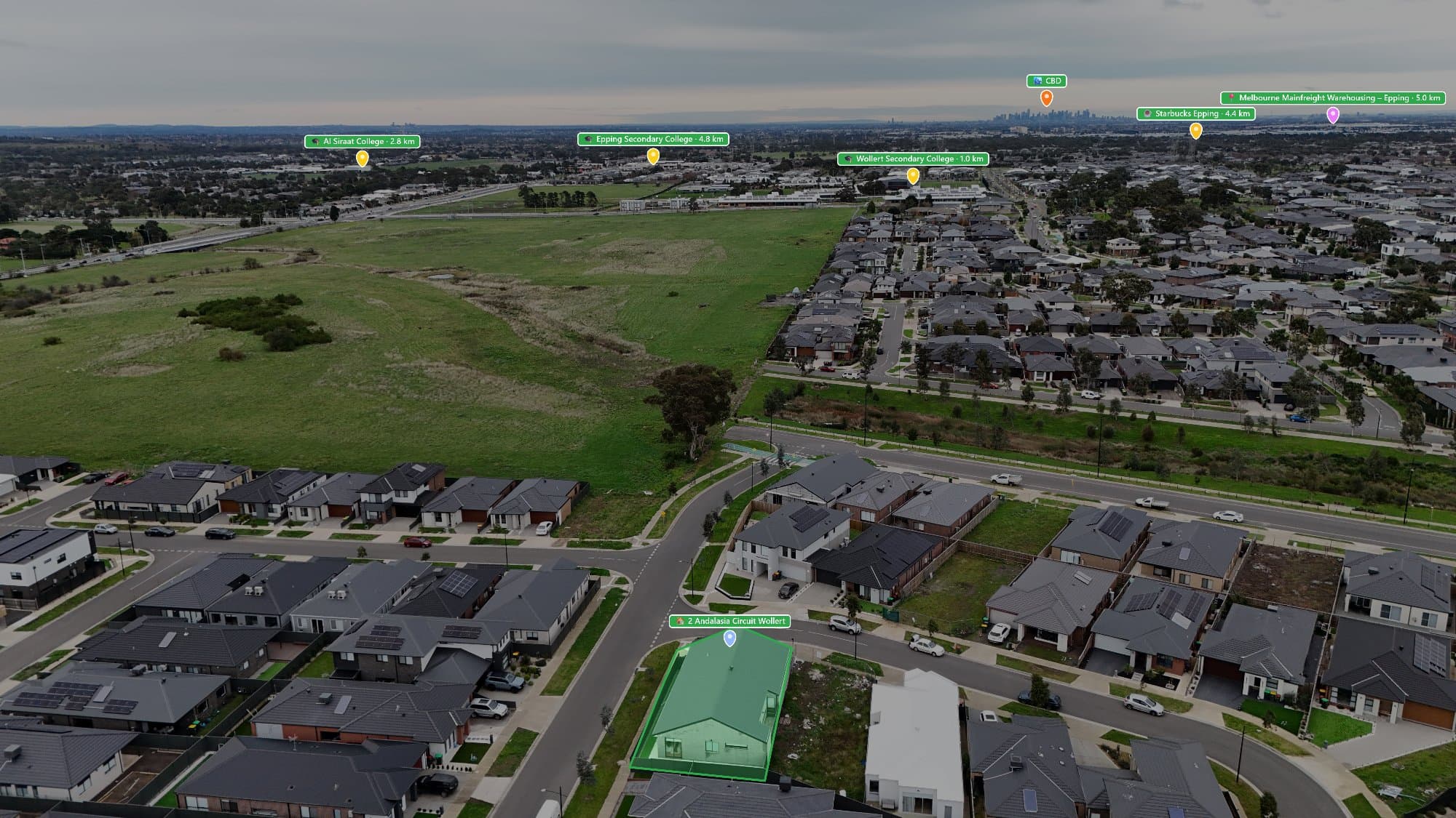
Drone photography has changed the way properties are marketed. Aerial shots help buyers see the home, the land, and the surrounding area. But a drone image becomes even more useful when you add Points of Interest (POIs) that show what is nearby.
Adding locations like schools, parks, shopping centres, transport, and cafés helps buyers understand the lifestyle around a property.
If you are looking for the best tool to add Points of Interest to drone shots, here are the options to consider.
What Is a Point of Interest Tool?
A Point of Interest tool allows you to add location markers and labels to drone images.
Instead of showing only a property from above, you can create an image that tells buyers:
- What is nearby
- How convenient the location is
- What lifestyle features are available
- Why the suburb is desirable
For real estate photographers, this adds extra value to standard drone photography.
AerialPin – Best Tool for Real Estate Drone Shots
AerialPin is built specifically for adding Points of Interest to real estate drone images.
Unlike general photo editing programs, AerialPin focuses on creating location-based aerial images for property marketing.
With AerialPin, photographers can:
- Find nearby Points of Interest
- Add schools, parks, shops, transport and more
- Create professional aerial annotations
- Save time compared to manual editing
- Produce marketing-ready drone images
For real estate photographers who create multiple property listings, having a tool that can quickly find and add nearby locations can save hours of work.
Why Use AerialPin Instead of Manual Editing?
Many photographers currently use a combination of Google Maps, Photoshop, and Canva to create annotated drone images.
The process usually involves:
- Searching for nearby locations
- Copying location names
- Creating icons or labels
- Placing them manually on the drone image
- Checking everything is accurate
While this works, it can become repetitive and slow.
A dedicated POI tool simplifies the process by helping you quickly create consistent, professional images.
What Points of Interest Should You Add?
The best locations depend on the property and target buyer.
Family Homes
Add:
- Schools
- Childcare centres
- Parks
- Shopping centres
- Medical facilities
Apartments
Add:
- Train stations
- Cafés
- Restaurants
- Shopping areas
- Business districts
Luxury Properties
Add:
- Beaches
- Golf courses
- Marinas
- Private schools
- Lifestyle attractions
Investment Properties
Add:
- Universities
- Transport links
- Employment areas
- Shopping centres
Why Real Estate Agents Like Annotated Drone Photos
A standard drone photo shows where the property is.
A drone photo with Points of Interest shows why the location matters.
Annotated images help agents:
- Create stronger listings
- Explain the suburb quickly
- Showcase nearby amenities
- Provide more value to sellers
- Stand out from competing properties
Make Drone Photography More Valuable
Drone photography is already a powerful marketing tool, but adding nearby locations takes it further.
By using a tool like AerialPin, photographers can create professional aerial images that highlight not only the property, but everything that makes the location attractive.
For real estate marketing, showing the full picture can help buyers connect with a property before they even inspect it.