
DJI Drone Aerial Annotations: How Real Estate Photographers Can Highlight Points of Interest
DJI drones capture incredible aerial views, but adding nearby points of interest can turn a simple drone photo into a powerful real estate marketing tool. Learn how photographers use aerial annotations to showcase schools, cafes, parks, transport, and lifestyle features.
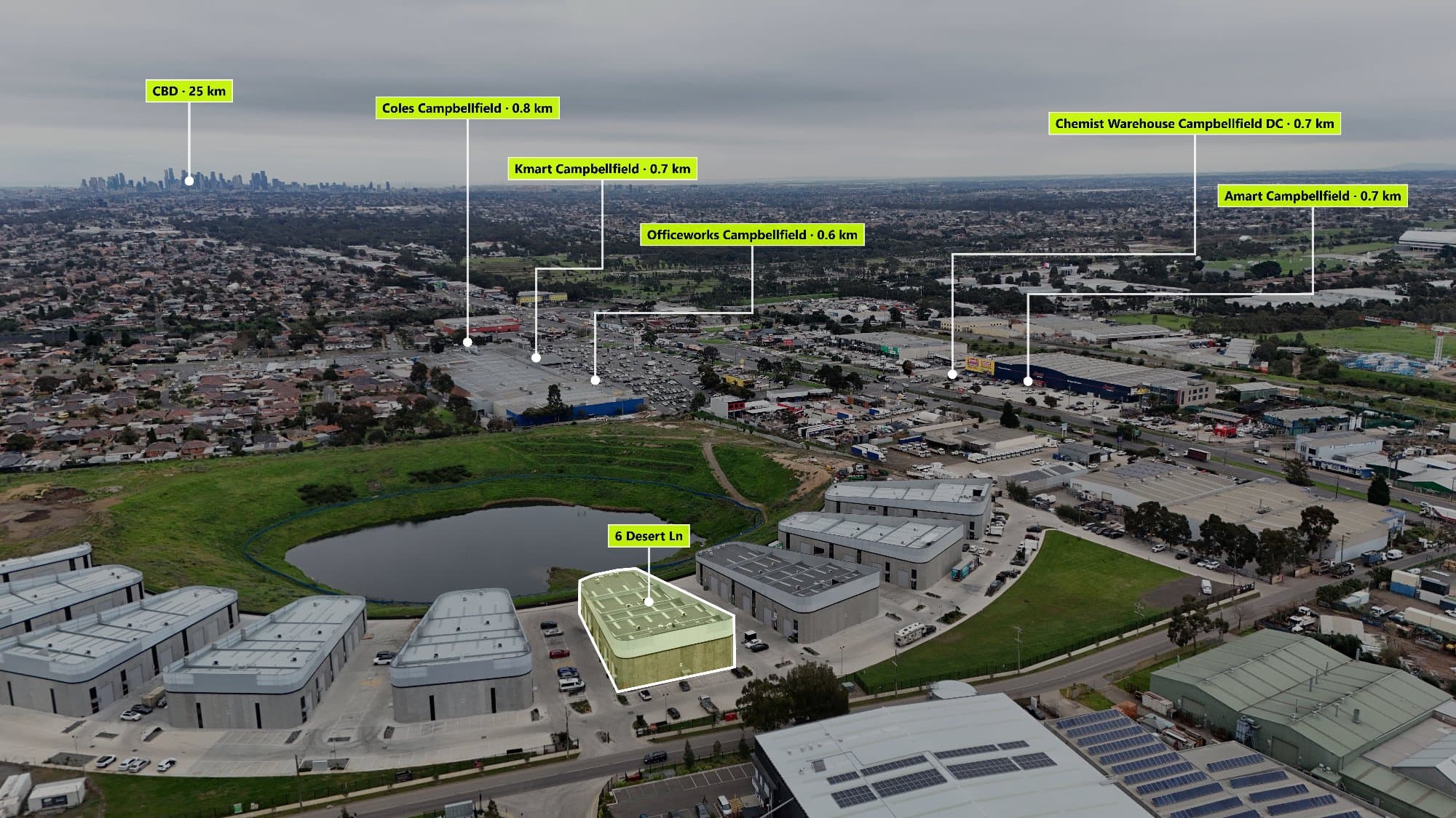
DJI Drone Aerial Annotations: How to Add Points of Interest to Real Estate Photos
Drone photography has completely changed the way properties are marketed.
With DJI drones like the DJI Mini series, Air series, and Mavic series, photographers can capture stunning aerial images that show homes from a perspective buyers rarely see.
But an aerial image only tells part of the story.
A buyer is not just purchasing a house — they are buying the location, lifestyle, and convenience that comes with it.
This is where aerial annotations and points of interest (POI) can make a major difference.
What Are Aerial Annotations in Drone Photography?
Aerial annotations are visual markers added to drone images that highlight important locations around a property.
These markers can show nearby:
- Schools
- Cafes and restaurants
- Shopping centres
- Parks
- Public transport
- Beaches
- Sports facilities
- Landmarks
Instead of showing a property from above with no context, annotations help buyers understand what surrounds the home.
Why DJI Drone Photos Are Perfect for Point of Interest Marketing
DJI drones are widely used by real estate photographers because they provide:
- High-resolution aerial images
- GPS location data
- Wide property perspectives
- Professional-quality footage
Many DJI drones also store location information inside the image metadata.
This GPS data can help identify where the image was captured and make it easier to add relevant nearby locations.
With tools like AerialPin, photographers can transform DJI drone images into interactive aerial marketing visuals by adding nearby points of interest.
Why Real Estate Buyers Care About Points of Interest
A drone photo shows the property.
A drone photo with annotations shows the lifestyle.
When buyers view a listing, they often ask:
- How far is the nearest school?
- Are there shops nearby?
- Is public transport accessible?
- What parks are close?
- What makes this location desirable?
Adding points of interest answers these questions before a buyer even contacts the agent.
How Real Estate Photographers Can Use Drone Annotations
1. Showcase Lifestyle Features
A property might be located near popular amenities that increase its appeal.
For example:
📍 500m to local cafes
📍 800m to a shopping centre
📍 5 minutes to a train station
📍 2 minutes to a nearby park
These details help create an emotional connection with potential buyers.
2. Create Better Marketing Material for Agents
Real estate agents are always looking for ways to make listings stand out.
A standard drone photo is useful, but an interactive aerial image provides something different.
Photographers can offer enhanced aerial marketing as part of their packages.
This helps increase the perceived value of drone services.
3. Save Time Creating Annotations
Creating aerial annotations manually can take a lot of time.
The workflow usually involves:
- Searching Google Maps
- Finding nearby locations
- Taking screenshots or collecting information
- Designing labels
- Placing them correctly on the image
For photographers managing multiple listings every week, this process quickly becomes repetitive.
AerialPin helps automate the process by finding nearby points of interest and making it easier to create professional aerial visuals.
Explore AerialPin features.
DJI Drone Models Commonly Used for Real Estate Photography
DJI Mini Series
The DJI Mini range is popular with photographers who need a lightweight drone that is easy to transport.
Benefits:
- Compact design
- High-quality images
- Great for residential properties
DJI Air Series
The DJI Air series offers a balance between portability and professional image quality.
Benefits:
- Better sensors
- Improved image quality
- Great for property marketing
DJI Mavic Series
The DJI Mavic range is widely used by professional drone operators.
Benefits:
- Advanced camera systems
- Longer flight times
- Professional aerial results
Improve Your Real Estate Drone Photography Workflow
The best real estate photographers are not just taking photos — they are creating marketing experiences.
Combining:
✓ DJI drone photography
✓ Professional editing
✓ Aerial annotations
✓ Location information
creates a stronger property presentation.
Buyers want to understand not only what a home looks like, but what life around that home looks like.
Final Thoughts
DJI drones have made aerial photography accessible to more real estate photographers than ever before.
The next step is making those images more informative.
Adding points of interest transforms a simple aerial photo into a powerful marketing tool that helps buyers understand the property and surrounding area.
With AerialPin, photographers can quickly create interactive aerial images with nearby locations and deliver more value to real estate clients.
Ready to upgrade your drone photography?
View AerialPin features
See AerialPin pricing
Start creating with AerialPin