
Drone Aerial Annotation: How to Annotate Drone Photos for Real Estate Marketing
Drone Aerial Annotation: Annotate Drone Photos for Real Estate Meta Description: Learn how drone aerial annotation can turn property photos into clear, professional marketing images with boundaries, pins, points of interest and location data.
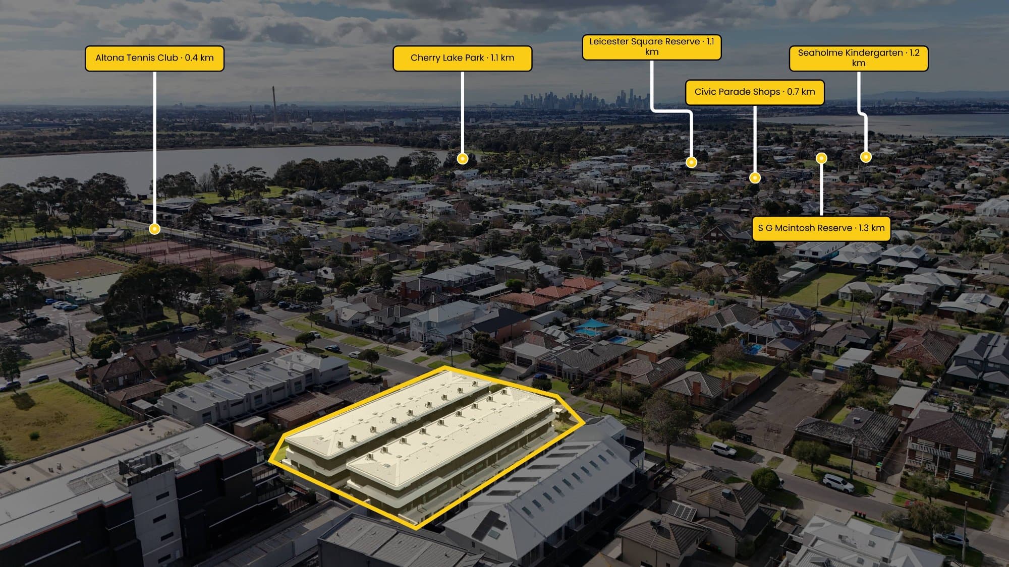
What Is Drone Aerial Annotation?
Drone aerial annotation is the process of adding visual information to drone photography to make a property easier to understand. This can include property boundaries, location pins, nearby landmarks, roads, parks, schools, shopping centres and other points of interest.
For real estate photographers and property marketers, annotated drone images can communicate information that a standard aerial photograph cannot.
Instead of simply showing a property from above, an annotated aerial image can show buyers exactly where the property sits within its surrounding area.
Why Use Annotated Drone Photos for Real Estate?
Aerial photography has become an important part of modern real estate marketing. However, an aerial photo without context can sometimes leave buyers guessing about the property's location and surroundings.
Drone aerial annotation adds that missing context.
Property marketers can use annotations to highlight:
- Property boundaries
- Lot dimensions
- Nearby schools
- Parks and reserves
- Shopping centres
- Train stations
- Major roads
- Beaches and recreational areas
- Points of interest
- Distances from the property
- Development opportunities
This can make property listings more informative while giving potential buyers a better understanding of the location.
Property Boundary Annotation
One of the most useful types of drone annotation is property boundary mapping.
A property boundary overlay can clearly show the exact area of a block, development site or parcel of land. This is particularly useful for vacant land, acreage, development sites and properties where the boundaries are difficult to identify from an aerial photograph.
Rather than manually drawing boundaries in Photoshop or another editing program, automated annotation tools can help speed up the process.
Add Points of Interest to Aerial Photos
Points of interest are another powerful way to enhance drone imagery.
For example, a real estate photographer could annotate an aerial photo with nearby:
Schools → Parks → Shops → Transport → Beaches → Major roads
Distance labels can also be added to help buyers quickly understand how close important locations are to the property.
This turns an ordinary drone photograph into a visual location map that can be used across property listings, social media, brochures and marketing campaigns.
How Automated Drone Annotation Saves Time
Manually annotating aerial photography can be surprisingly time-consuming.
A typical workflow may involve:
- Opening the drone photograph in an editing application.
- Finding the property's location.
- Identifying the property boundary.
- Searching for nearby locations.
- Adding pins manually.
- Calculating distances.
- Designing labels.
- Aligning everything with the aerial image.
- Exporting the final image.
For photographers processing multiple properties every week, these extra steps can quickly add up.
Automated drone annotation software can simplify much of this workflow by using location data from the image and automatically placing relevant information onto the aerial photograph.
GPS and EXIF Data in Drone Photography
Many drone photographs contain GPS information inside their EXIF metadata.
This information can include the coordinates where the photograph was captured, along with other camera and flight information.
Annotation software can use this geographic information to help determine where the aerial photograph was taken. This makes it possible to connect the image with mapping data and identify nearby points of interest.
For photographers using DJI drones and other GPS-enabled cameras, this can significantly reduce manual location work.
Drone Annotation for Property Marketing
Annotated aerial photography is particularly useful for real estate agents, developers, builders and property photographers.
A single aerial image can communicate:
Where is the property?
How large is the site?
What's nearby?
How far away are important amenities?
What surrounds the property?
This information can make property marketing more visually engaging and easier for potential buyers to understand.
Aerial Annotation vs Traditional Image Editing
Traditional image editing software gives photographers complete creative control, but it can require a lot of manual work when creating maps and property annotations.
Drone annotation software is designed specifically around this workflow.
Instead of spending significant time manually drawing boundaries, searching for locations and positioning labels, photographers can automate repetitive parts of the process and focus on producing the final marketing asset.
The goal isn't to replace professional photography or editing. It's to remove repetitive tasks from the workflow.
How AerialPin Makes Drone Annotation Faster
AerialPin is built specifically for annotating aerial photography.
With AerialPin, photographers can work with their drone images to add property boundaries, pins and points of interest without building the entire annotation manually from scratch.
The workflow is designed to make aerial property marketing faster, particularly for real estate photographers who need to process multiple images and properties.
Instead of spending 20–30 minutes manually creating an annotated aerial image, automation can help reduce the process to seconds.
The Future of Real Estate Drone Photography
Drone photography is no longer just about capturing impressive views from above.
As property marketing becomes increasingly visual, aerial imagery can also become a source of useful location information.
Combining drone photography, mapping data, GPS information and automated annotation creates a more informative property marketing asset.
For real estate photographers, the biggest opportunity is simple: capture the image once and let software do more of the repetitive work.
Final Thoughts
Drone aerial annotation can transform a standard property photograph into a powerful visual marketing tool.
By adding property boundaries, points of interest, distances and location information, real estate professionals can give buyers more context while creating content that stands out from traditional property photography.
As automation continues to improve, annotating drone images is becoming faster, easier and more accessible for photographers and property marketers.
Ready to spend less time manually annotating aerial photos? Try AerialPin and automate your property annotation workflow.