
Drone EXIF Data Explained: How Real Estate Photographers Can Use GPS Data From Their Drone Photos
Learn how drone EXIF data, GPS coordinates, altitude and camera heading can help real estate photographers label drone photos and create aerial property marketing images.
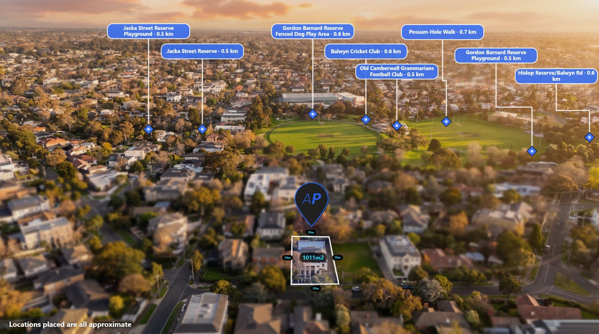
If you photograph properties with a drone, your images may contain more information than you realise.
Inside many drone photographs is metadata known as EXIF data. This information can include the GPS location of the drone, altitude, camera direction and other details about how the photograph was captured.
For real estate photographers, this data can be extremely useful.
Instead of manually entering a property's location every time you want to create an annotated aerial image, you can use the information already stored inside the photograph.
Tools like AerialPin can use this information to help real estate photographers create property marketing images with nearby locations, boundaries and labels.
What Is EXIF Data?
EXIF stands for Exchangeable Image File Format.
It is metadata stored inside an image file that can contain information about the photograph.
Depending on the camera or drone, EXIF data can include:
- GPS latitude
- GPS longitude
- Altitude
- Camera heading
- Gimbal angle
- Camera model
- Lens information
- Date and time
- Image dimensions
Not every drone stores every piece of information, but many modern drones record useful metadata.
For aerial photography, GPS and camera orientation information can be particularly valuable.
Why Is Drone EXIF Data Useful?
Imagine you have just completed a real estate drone shoot.
You have 30 aerial photographs.
Now your client asks you to create an annotated image showing nearby schools, parks, shopping centres and transport.
Without the correct location data, you may need to manually identify where each photograph was taken.
With GPS information stored in the photograph, software can potentially determine the location automatically.
That means your workflow can go from:
"Where was this photo taken?"
to:
"What nearby information should I add to this photo?"
That can save a significant amount of time.
How to Check Drone EXIF Data
You can use an EXIF viewer or metadata tool to inspect the information stored inside an image.
Upload a drone photograph and you may be able to see information such as its GPS coordinates, altitude and camera details.
AerialPin is designed around this type of aerial image information, allowing you to upload your drone photo and work with its location and camera data.
GPS Coordinates Can Identify the Photograph's Location
GPS coordinates are one of the most useful pieces of metadata in a drone photograph.
Latitude and longitude can identify the approximate location where the image was captured.
For a real estate photographer, this can remove the need to manually enter the property address into another application.
Once the location is known, nearby points of interest can be searched.
For example:
Drone photo GPS
→ Property location
→ Nearby schools
→ Nearby shopping
→ Nearby parks
→ Nearby transport
→ Other points of interest
This creates the foundation for automated aerial image annotation.
Drone Heading Matters Too
Knowing where the drone was located is only part of the problem.
You also need to know which direction the camera was facing.
A drone photograph might have been captured at a property in Melbourne, but the camera could be facing north, south, east or west.
A nearby shopping centre might be only 500 metres away but not actually visible in the photograph.
This is why camera heading and gimbal information can be useful when creating automated annotations.
AerialPin can use supported drone metadata to help determine the camera's position and orientation.
Use Drone Data to Find Nearby Locations
Once the location and orientation of the aerial photograph are understood, nearby places become much easier to work with.
AerialPin can help you search for relevant points of interest around the property.
You can add locations such as:
- Schools
- Parks
- Shopping centres
- Train stations
- Roads
- Beaches
- Sporting facilities
- Other local amenities
These locations can then be displayed as pins and labels directly on the aerial photograph.
Add locations to your drone photos with AerialPin
Automatically Place Pins on Drone Photos
Manually positioning every label can still take time.
This is where AI Auto Place can help.
AerialPin uses information from the drone photograph to help determine which locations are relevant to the camera's view and where they should appear on the image.
The result is an initial set of automatically positioned pins that you can review and adjust.
This can be particularly useful when you're creating multiple annotated aerial photographs for real estate listings.
Add Property Boundaries
Drone EXIF data can help identify where the photograph was taken, but property marketing often requires more information.
One of the most common additions is the property boundary.
AerialPin allows you to create property boundary overlays directly on the aerial image.
You can use the boundary to show the exact land being marketed and make the property easier for buyers to understand from above.
This can be especially valuable for:
- Acreage
- Large blocks
- Development land
- Rural properties
- Vacant land
- Commercial properties
Why This Is Useful for Real Estate Photographers
Real estate photographers often have to balance quality with speed.
You need to capture the property, edit the images, deliver the final photographs and often make additional marketing assets.
Every repetitive task adds more time to the workflow.
Using drone EXIF data can help automate some of the work involved in creating annotated aerial photographs.
Instead of manually entering location information, you can start with the metadata already contained in the image.
Instead of manually searching for every nearby location, you can use location-based search.
Instead of manually positioning every pin, AI can help create an initial layout.
What Happens If Your Drone Photo Has No GPS Data?
Not every image will contain usable GPS information.
Metadata can sometimes be removed when images are edited, exported, compressed or processed through other software.
For this reason, it is a good idea to keep the original drone photograph when working with location-based aerial image tools.
If you've already edited the image and removed its metadata, you may need to use the original file to recover the location information.
AerialPin is designed to work with the original drone image so the available metadata can be used during the workflow.
Keep Your Original Drone Files
If you're a professional real estate photographer, your original drone files can contain valuable information.
Rather than immediately overwriting or removing the originals, keep them stored safely.
Your original files can preserve:
- GPS information
- Camera information
- Flight-related metadata
- Original image quality
- Other EXIF information
This can be useful later when creating maps, annotations or other location-based marketing assets.
From EXIF Data to Real Estate Marketing
The real value of drone EXIF data isn't simply being able to view GPS coordinates.
The interesting part is what you can do with that information.
A photograph can provide the location.
The location can provide nearby places.
The drone's orientation can help determine what is visible.
That information can then be turned into useful marketing annotations.
The workflow becomes:
Drone photo → EXIF data → GPS location → nearby places → annotations → finished marketing image
This is exactly the type of workflow AerialPin is designed to simplify.
A Smarter Workflow for Drone Photographers
Instead of manually rebuilding the location information for every aerial photograph, you can let the drone image provide some of the information needed to get started.
Upload the original drone image to AerialPin, find nearby locations, add your property boundary, customise your labels and export the finished aerial marketing image.
What starts as a simple drone photograph can become a much more informative property marketing asset.
Start Using Your Drone's Data
Your drone isn't just taking a photograph.
It may also be recording useful information about where and how that photograph was captured.
For real estate photographers, that data can make aerial image annotation much faster.
If you want to inspect your drone's metadata, find nearby locations, label aerial photographs and create property marketing images, try AerialPin.
Your drone captured the data. AerialPin helps you put it to work.