
Drone Photography Tips for Real Estate: How to Capture Better Property Photos
Discover the best drone photography tips for real estate and learn how photographers can capture better aerial property images, improve marketing results and use tools like AerialPin to create professional location-based drone content.
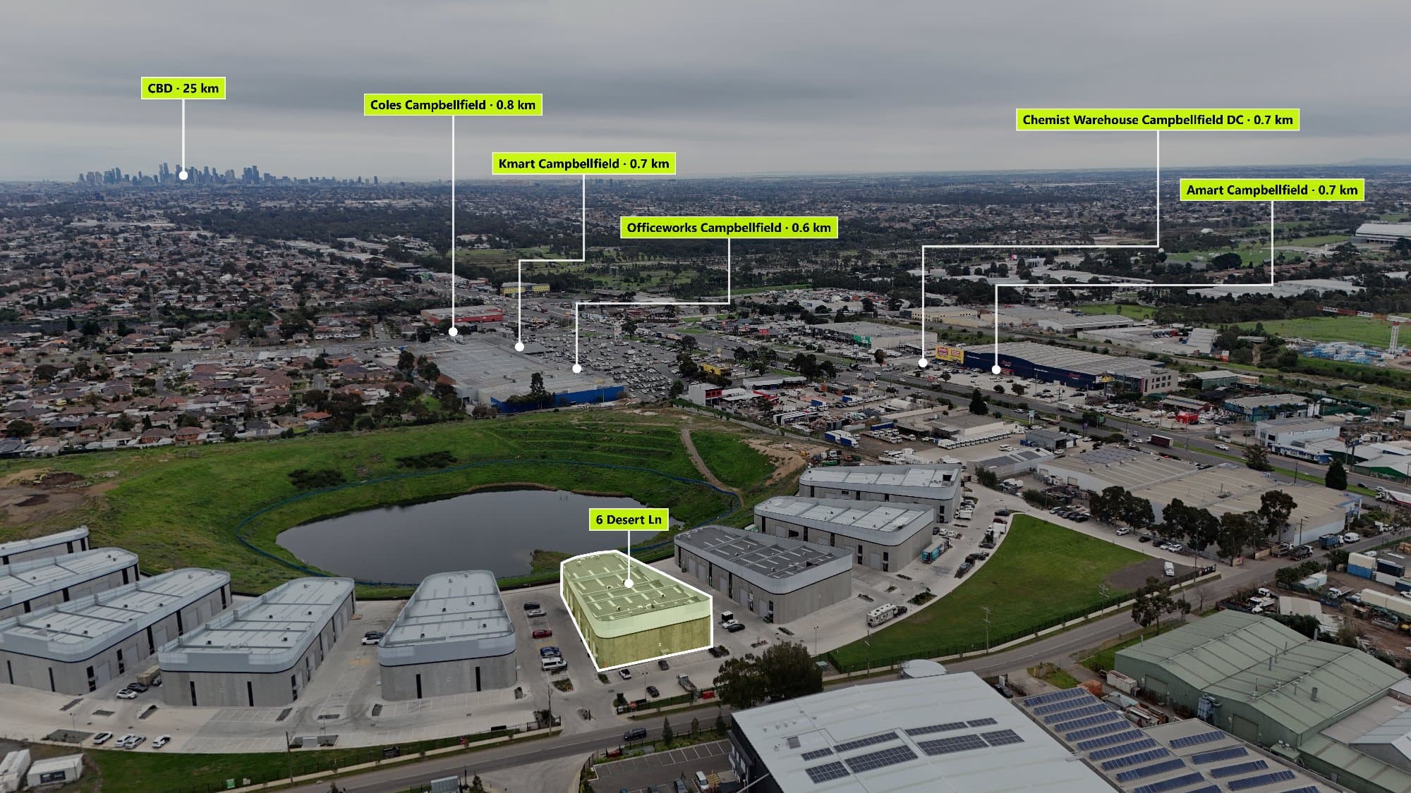
Learn how to capture professional drone photos for real estate listings with these essential aerial photography tips. Discover how composition, camera settings and AI-powered tools like AerialPin can help create better property marketing images.
Drone photography has become one of the most effective ways to showcase real estate. Aerial images give buyers a unique perspective of a property, helping them understand the home's position, surrounding landscape and nearby amenities.
However, creating a great real estate drone photo requires more than simply flying a drone and pressing the shutter button.
Professional aerial photography combines planning, composition, lighting, camera settings and editing to create images that attract buyers.
Whether you are a real estate photographer, agent, builder or property developer, improving your drone photography workflow can help you create more valuable marketing content.
Why Drone Photography Is Important for Real Estate
Aerial photography helps buyers understand information that ground-level photos cannot show.
A drone image can highlight:
- Property boundaries
- Backyard size
- Surrounding streets
- Landscaping
- Nearby parks
- Schools
- Transport options
- Neighbourhood layout
For many buyers, location is just as important as the home itself.
A well-composed aerial image can communicate the lifestyle and convenience of a property within seconds.
1. Plan Your Drone Flight Before Shooting
Professional drone photography starts before the drone leaves the ground.
Before flying, consider:
- The property's best angles
- Sun direction
- Weather conditions
- Nearby obstacles
- Important surrounding features
Planning your shots ensures you capture images that tell a story instead of random aerial photos.
For real estate, the goal is not only to show the house. It is to showcase why the location matters.
2. Shoot During the Best Lighting Conditions
Lighting has a major impact on aerial photography.
The best times to capture real estate drone photos are usually:
Golden Hour
The period shortly after sunrise or before sunset creates softer light, longer shadows and a premium look.
Overcast Conditions
Cloudy weather can create even lighting and reduce harsh shadows.
Avoid Harsh Midday Sun
Strong overhead sunlight can make properties appear flat and create unwanted contrast.
3. Use the Right Camera Settings
Most modern drones produce excellent images, but adjusting settings can improve results.
Recommended settings:
- Shoot in RAW format when available
- Use a lower ISO to reduce noise
- Keep shutter speed high enough to avoid motion blur
- Adjust white balance manually for consistency
RAW images also provide more flexibility during editing.
4. Capture Multiple Heights and Angles
A common mistake is only capturing one type of aerial shot.
A strong real estate drone package should include different perspectives.
Useful shots include:
High Overview Shots
These show:
- The property's location
- Surrounding streets
- Nearby amenities
Medium Altitude Shots
These provide a balance between the property and surrounding area.
Lower Angle Shots
These create a more immersive perspective and highlight architecture.
5. Show Nearby Amenities
One of the biggest advantages of drone photography is showing location.
A property may be close to:
- Parks
- Schools
- Shopping centres
- Beaches
- Transport
However, buyers may not immediately know where these features are.
This is where aerial annotations become valuable.
Using AerialPin, photographers can automatically add Point of Interest labels to drone images, helping buyers understand what surrounds a property.
6. Keep Your Composition Clean
Great aerial photography still follows traditional photography principles.
Consider:
- Leading lines
- Symmetry
- Balance
- Negative space
- Property positioning
Avoid cluttered images where the main subject becomes unclear.
The property should remain the focus.
7. Edit Drone Photos Professionally
Editing helps bring out the best in aerial images.
Common adjustments include:
- Exposure correction
- Colour balancing
- Contrast adjustments
- Shadow recovery
- Sky improvements
- Removing distractions
A consistent editing style helps create a professional property brand.
8. Add Context With POI Labels
Aerial images become even more powerful when they explain the surrounding area.
A Point of Interest overlay can show:
- Nearby schools
- Shopping centres
- Parks
- Transport
- Lifestyle locations
Instead of making buyers research the area themselves, the image provides the information instantly.
AerialPin helps automate this process by using drone metadata and AI technology to place accurate location markers onto aerial photos.
Common Drone Photography Mistakes
Flying Too High
Higher is not always better.
Extreme heights can make properties feel small and disconnected.
Ignoring the Surroundings
Aerial photography should show more than the roof.
The surrounding neighbourhood is often a major selling point.
Overediting Images
Heavy editing can make properties look unrealistic.
Professional editing should enhance the image while keeping it natural.
Not Providing Location Context
A beautiful aerial image is useful, but an informative aerial image is more valuable.
How AerialPin Helps Real Estate Photographers
AerialPin helps photographers turn drone images into more informative marketing assets.
Instead of manually searching maps and placing labels, photographers can:
- Upload drone photos
- Automatically detect nearby locations
- Add professional POI overlays
- Customise labels
- Export finished images
This creates a faster workflow while helping clients deliver better property marketing.
The Future of Real Estate Drone Photography
Drone photography is becoming smarter.
The next generation of aerial marketing will combine:
- High-quality photography
- AI automation
- Location intelligence
- Interactive property information
Photographers who adopt smarter workflows will be able to deliver more value while reducing editing time.
Final Thoughts
Great real estate drone photography is about more than capturing a property from above.
The best aerial images tell a story about the home, the neighbourhood and the lifestyle surrounding it.
By combining professional drone techniques with tools like AerialPin, photographers can create powerful marketing images that help buyers understand the full value of a property.