
How AerialPin Makes Real Estate Drone Photography More Powerful
Discover how AerialPin helps real estate agents and drone photographers create professional aerial property marketing images with AI pins, boundaries, nearby locations and AI relighting.
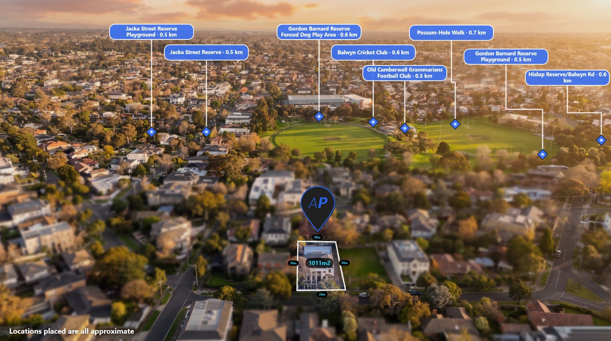
Drone photography has become an important part of modern real estate marketing.
Aerial images can show buyers the size of a property, its surrounding streets, nearby amenities and its position within the local area. But a raw drone photograph only tells part of the story.
Adding property boundaries, nearby locations, labels and other information can turn a simple aerial photograph into a powerful property marketing asset.
The problem is that creating these images manually can take time.
AerialPin is built to make that process faster.
AerialPin is an aerial image annotation and AI-powered property marketing tool designed for real estate agents, drone photographers, property marketers and developers.
From Drone Photo to Marketing Image
A typical drone workflow might look simple.
You take the photo, edit it and deliver it to the client.
But when a client wants an annotated aerial image, things become more complicated.
You may need to find the property's location, identify nearby schools and shopping centres, find the property boundary, add labels and manually position everything in Photoshop or another design application.
AerialPin brings these tools together in one browser-based workflow.
You can upload a JPEG or DNG directly from your drone and AerialPin can read the location and camera information contained in the image.
From there, you can start building your finished aerial marketing image.
Automatically Add Nearby Locations
One of the biggest challenges with aerial property marketing is showing buyers what is around the property.
AerialPin can find nearby points of interest such as:
- Schools
- Parks
- Shopping centres
- Public transport
- Retail
- Roads
- Other local amenities
The platform uses real location information to find nearby places rather than relying on a generic map template.
This means you can create an aerial image that gives buyers a much clearer understanding of the property's location.
AI Auto Place Your Property Pins
Manually placing every pin on a drone photograph can be frustrating.
AerialPin's AI Auto Place feature uses the GPS position, altitude, compass heading and gimbal angle stored in the drone photograph to determine which nearby places can actually appear within the camera's view.
It can then automatically position the relevant pins on the aerial image.
This is particularly useful when you're working with multiple properties and don't want to spend several minutes positioning every label by hand.
Draw Property Boundaries
Property boundaries are another important part of real estate aerial photography.
With AerialPin, you can click directly on the aerial image to create a property boundary.
You can customise the fill, stroke and spotlight, while also displaying individual edge lengths and the total property area in metric or imperial measurements.
This can be useful for:
- Acreage properties
- Development sites
- Vacant land
- Large residential properties
- Rural properties
- Commercial properties
A boundary overlay can instantly help a potential buyer understand exactly which part of the image represents the property.
Create Consistent Real Estate Marketing Images
Every agency has its own branding.
You might want a specific pin shape, colour, font or label style across all your listings.
AerialPin lets you customise your annotation styles and save them as reusable templates. This means you can create a consistent visual style and apply it to future aerial images.
For photographers and agencies working with multiple listings, this can make the workflow much more efficient.
Use AI to Change the Time of Day
AerialPin also includes AI Relight, which can transform the lighting of an aerial property photograph.
You can create different looks such as:
- Bright day
- Golden hour
- Twilight
- Clear sky
The property, buildings, ground and landscaping remain based on the original photograph while the sky and lighting are changed.
This gives photographers and agents another way to create visually appealing property marketing images from an existing aerial photograph.
Who Can Use AerialPin?
AerialPin is designed for anyone who uses aerial photography for property marketing.
Real Estate Agents
Agents can create more informative aerial images for property listings, social media campaigns, websites and brochures.
Drone Photographers
Drone photographers can add annotated aerial imagery to their services without having to manually build every graphic from scratch.
Property Marketers
Marketing teams can create consistent aerial visuals across multiple properties and campaigns.
Property Developers
Developers can use boundaries, nearby locations and aerial imagery to communicate the location and scale of a development site.
Why Use AerialPin Instead of Doing Everything Manually?
The traditional process can involve multiple tools.
You might use one application to edit the drone photograph, another to find nearby locations, another to work with maps and another to create the final graphic.
AerialPin is designed to bring the aerial annotation workflow into one place.
The idea is simple:
Take the drone photo. Let AerialPin handle the repetitive work. Create the finished marketing image.
Built for Real Estate Drone Photography
AerialPin isn't designed to replace the photographer.
The drone photograph is still the foundation of the marketing image.
Instead, AerialPin helps add the information and visual context that can make the photograph more useful.
A raw aerial image shows a property.
An annotated aerial image can show the property, its boundaries, nearby amenities and the surrounding area in one visual.
That extra context can make a big difference when marketing a property.
Start With AerialPin
If you're a real estate agent, drone photographer, property marketer or developer, you can try AerialPin directly in your browser.
You can start with 10 free credits without a credit card and explore the tools before choosing a paid plan.
Turn your aerial images into smarter property marketing visuals with AerialPin.