
How Real Estate Photographers Are Using AerialPin to Create Better Drone Marketing Images
Real estate photographers are using AerialPin to turn standard drone photographs into polished marketing visuals with property boundaries, location markers, labels and other aerial annotations.
A drone photo can already be one of the strongest images in a property listing.
But some real estate photographers are taking their aerial photography a step further.
Instead of simply delivering the drone image, they're adding useful visual information that helps buyers understand the property and its surroundings.
That's where AerialPin comes in.
From Drone Photo to Marketing Visual
A standard aerial photograph might show a house, backyard and surrounding streets.
It's useful, but the viewer still has to work out what's important.
Where does the property end?
How big is the block?
What's that park in the distance?
How close is the shopping centre?
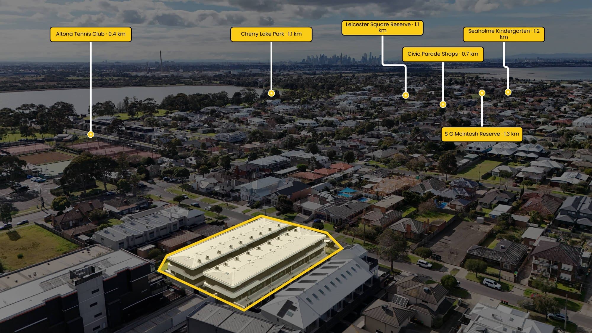
With AerialPin, photographers can add this information directly to the aerial image.
A clean property outline can show the land.
A label can identify the subject property.
Pins can highlight nearby locations.
A spotlight can make the property stand out from the surrounding homes.
The result is an image that looks more like a finished marketing asset than a raw aerial photograph.
Photographers Are Already Using It
Multiple real estate photographers are now using AerialPin as part of their aerial photography workflow.
The appeal is fairly simple.
Photographers are already spending time capturing high-quality drone images. Adding useful annotations gives them another way to present that work to their real estate clients.
Instead of delivering the same aerial photograph that every other photographer could provide, they can create something more distinctive.
These photographers are using the software to create stunning marketing visuals that combine their photography with property information and location-based graphics.
It's particularly useful for photographers who want to offer something extra without spending hours building every graphic manually.
Property Boundaries Are One of the Most Popular Uses
One of the simplest additions can also have one of the biggest impacts.
Property boundaries aren't always obvious from a drone.
A fence might not exist. Trees can hide the edge of the property. On larger blocks, neighbouring land can look almost identical.
AerialPin lets photographers create a clean boundary directly over their aerial image.
The photographer can then customise the line and add a subtle fill or spotlight to make the property easier to identify.
For acreage, vacant land and development sites, this can be particularly effective.
Turning Location Into Part of the Image
Real estate isn't just about the house.
Location is one of the biggest selling points of a property.
Aerial photography provides an opportunity to show that location visually.
A photographer might highlight a nearby park, school, shopping centre, beach or train station directly on the image.
AerialPin AI Auto Place can help with this by using location and camera information from compatible drone photographs to identify and position nearby points of interest.
Instead of manually searching for every location and trying to work out where each pin belongs in an angled photograph, photographers can use the automated workflow and make adjustments where necessary.
Why This Works So Well for Real Estate
People process visual information quickly.
A buyer scrolling through a property listing may not stop to read a long description about the size of the block or what's nearby.
But they can understand a visual almost instantly.
A boundary shows the land.
A pin shows the location.
A label provides context.
A spotlight tells them where to look.
All of this can be communicated in a single image.
It Also Gives Photographers Something Different to Offer
Real estate photography is competitive.
Most photographers can provide high-quality interior photographs.
Many can provide video.
More and more are offering drone photography.
Creating custom aerial marketing visuals gives photographers another way to differentiate their service.
Rather than simply saying:
“Aerial photography included.”
you can provide an aerial image that has been specifically designed around the property.
That becomes another piece of marketing content for the agent to use on the listing, social media, brochures or presentations.
It Doesn't Need to Look Complicated
One of the best things about aerial annotation is that it doesn't need to cover the entire photograph.
The strongest visuals are often quite simple.
A property boundary.
One property label.
Two or three relevant locations.
That's it.
The photograph remains the hero while the annotations provide additional context.
Good design is about knowing what to leave out as much as what to include.
AerialPin Fits Into the Existing Photography Workflow
Photographers don't have to completely change the way they work.
The process can be as simple as:
Fly the property → Capture the aerial photos → Upload to AerialPin → Add the boundary → Add locations → Export.
The original photography remains the foundation.
AerialPin simply adds another layer of information and presentation on top.
For photographers working across multiple listings, this can also make it easier to maintain a consistent style across their work.
The Future of Real Estate Aerial Photography
Drone photography has already changed the way properties are marketed.
The next step isn't necessarily taking bigger or more dramatic drone photographs.
It's making those photographs more useful.
That's what we're seeing photographers use AerialPin for.
They're taking the aerial photography they're already producing and turning it into polished marketing visuals that communicate the property, its boundaries and its surroundings in a single image.
If you're a real estate photographer looking for a drone image annotation tool, AerialPin gives you the tools to create property boundaries, labels, spotlights and nearby points of interest without having to build every graphic from scratch.
Try AerialPin and see what you can create with your next aerial property photo.