
How Real Estate Photographers Can Add Points of Interest to Aerial Images
Learn how to add points of interest to real estate aerial images and highlight schools, parks, transport, shopping and nearby amenities.
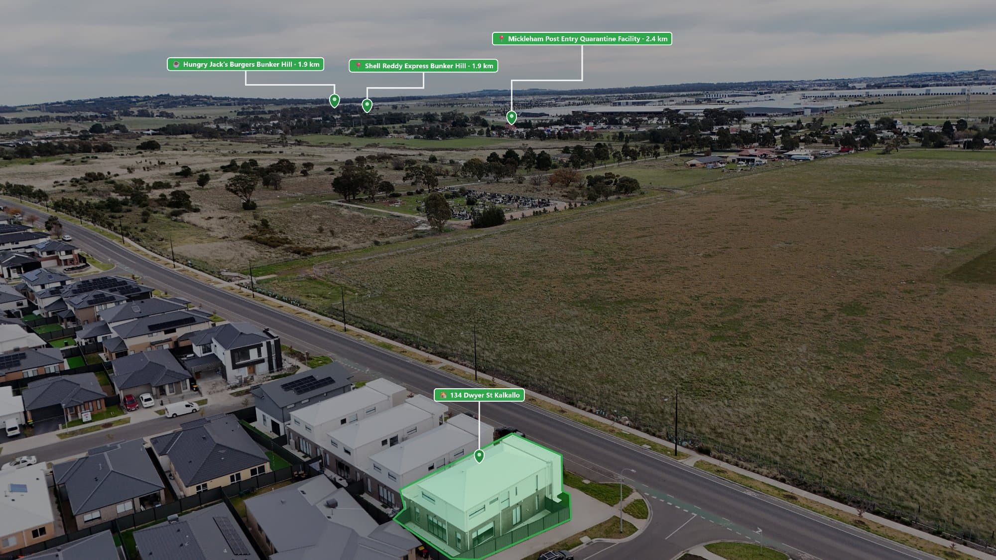
Real estate buyers want more than just a photo of a house. They want to know what the surrounding area offers, including nearby schools, parks, shopping, transport, and lifestyle attractions.
Adding Points of Interest (POIs) to aerial images is a simple way to make drone photography more informative and help properties stand out online.
Why Add Points of Interest to Aerial Real Estate Photos?
A drone image gives buyers a view of the property, but it does not always explain what is nearby.
Adding POI markers helps showcase:
- Nearby amenities
- Suburb lifestyle
- Convenience of the location
- Important selling points
- The overall neighbourhood
For buyers who are unfamiliar with an area, an annotated aerial image can quickly show why a property location is valuable.
The Most Valuable Points of Interest for Property Listings
Not every nearby location needs to be included. The best annotations focus on features that influence buying decisions.
Schools and Education
Schools are one of the most searched features by families.
Consider highlighting:
- Primary schools
- Secondary schools
- Childcare centres
- Universities
- TAFE campuses
Shopping and Dining
Lifestyle is an important factor for many buyers.
Useful locations include:
- Shopping centres
- Supermarkets
- Cafés
- Restaurants
- Local shopping strips
Transport Options
Transport accessibility can significantly impact a property's appeal.
Add nearby:
- Train stations
- Bus stops
- Tram stops
- Major roads
- Freeway access
Parks and Recreation
Outdoor spaces help buyers imagine living in the area.
Popular POIs include:
- Parks
- Playgrounds
- Walking trails
- Sporting facilities
- Golf courses
Lifestyle Attractions
For premium properties, highlight features that create a lifestyle appeal.
Examples include:
- Beaches
- Rivers
- Marinas
- Entertainment areas
- Popular landmarks
How to Create Professional POI Annotations
Creating quality aerial annotations requires more than just adding text over an image.
Professional drone photo annotations should include:
Accurate Placement
Markers should point to the exact location of each nearby feature. Incorrect labels can reduce trust in the marketing material.
Clean Design
Use:
- Simple icons
- Easy-to-read text
- Consistent colours and styling
- Clear spacing
The goal is to enhance the image, not distract from the property.
Relevant Information
Avoid adding too many locations. Focus on the amenities that matter most to potential buyers.
A clean image with five valuable POIs is usually more effective than one crowded with twenty markers.
The Challenge With Adding POIs Manually
Many photographers use a combination of Google Maps and editing software to create aerial annotations.
This process usually involves:
- Searching for nearby locations
- Taking screenshots or notes
- Designing markers
- Manually placing each label
- Exporting the final image
While this works, it can become time-consuming when creating multiple real estate listings every week.
Automatically Add Nearby Points of Interest With AerialPin
AerialPin helps real estate photographers create professional annotated drone images faster.
Instead of manually searching for every nearby location, AerialPin helps you discover relevant Points of Interest and add them directly to aerial photos.
Features include:
- Nearby POI search
- Real estate-focused annotations
- Professional aerial image layouts
- Faster editing workflow
- High-quality exports
For photographers looking to offer premium drone marketing services, adding location information can create more value for agents and sellers.
How POI Images Help Real Estate Marketing
Annotated drone photos can be used across:
- Real estate listings
- Agent websites
- Social media campaigns
- Property brochures
- Digital advertising
They help buyers understand the property location before they even book an inspection.
A well-designed aerial image does more than show where a property is located—it explains why the location matters.