
How to Add Location Pins to Aerial Photos
Learn how to add location pins to aerial photos and highlight nearby schools, parks, shopping centres, roads and other points of interest. AerialPin makes it easy to search for nearby places and add clear location markers directly to your drone photography.
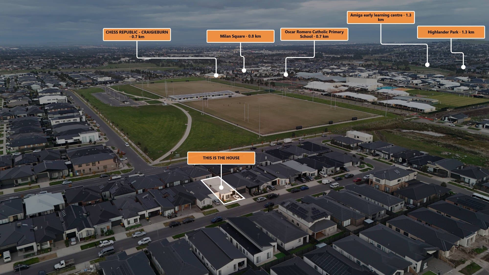
Aerial photography gives you a great view of a property, but sometimes the image needs more context.
If you're using drone photos for real estate marketing, land sales or property development, adding location pins can help viewers understand what's around the property.
You can highlight nearby schools, parks, shopping centres, train stations, roads and other important points of interest directly on the aerial image.
Here's how to add location pins to aerial photos using a browser-based workflow.
What Are Location Pins on Aerial Photos?
Location pins are visual markers placed over an aerial photograph to identify a specific place.
For example, a real estate aerial photo could include pins for:
- Local schools
- Shopping centres
- Train stations
- Parks
- Cafes
- Main roads
- Sporting facilities
- Beaches
- Other points of interest
Instead of describing these locations separately, you can show them directly on the photograph.
This can make an aerial property image much easier to understand.
Why Add Location Pins to Drone Photos?
A raw drone photo can show the property and its surroundings, but viewers may not immediately recognise everything in the image.
Location pins provide additional context.
For example, an aerial photograph might show a large green area next to a property. A location pin can identify it as a local park.
Similarly, a nearby building could be labelled as a school or shopping centre.
This is particularly useful for property marketing because location is often an important part of how buyers evaluate a property.
How to Add Location Pins to an Aerial Photo
1. Capture Your Drone Photograph
Start with a clear aerial photograph of the property or area you want to market.
If possible, keep the original drone image because the original file may contain GPS information in its EXIF metadata.
GPS information can help determine where the photograph was captured.
2. Upload the Image
Upload your aerial photograph into your annotation software.
A browser-based workflow means you can work directly from your computer without needing a complicated mapping or graphic design setup.
AerialPin is designed specifically for this type of aerial photography workflow.
3. Search for Nearby Locations
Once the image is loaded, you can search for nearby places that you want to highlight.
With AerialPin Nearby Search, you can search for points of interest around the property's location.
For example, you could search for locations such as:
Schools
Parks
Shopping
Transport
Roads
Restaurants
The available results can then be added to the aerial image as location pins.
4. Position Your Pins
After selecting the locations you want to show, position the pins clearly on the aerial photograph.
Try to avoid placing too many pins close together.
The goal is to make the image easier to understand, not cover the entire photograph with markers.
5. Add Labels
Location pins work particularly well when combined with clear labels.
For example:
Greenvale Shopping Centre
Local Primary School
Train Station
Community Park
Clear labels allow someone viewing the image to understand the surrounding area without needing additional explanation.
AerialPin also includes text tools for adding custom labels.
Use AI to Place Locations
If you regularly create annotated aerial photographs, manually adding every location can become repetitive.
AerialPin AI Auto Place can help automate the process.
The tool can use available GPS and camera information along with nearby places to help determine which locations are relevant to the aerial photograph.
This can be particularly useful when preparing multiple property images.
Add Property Boundaries
Location pins can be even more useful when combined with a property boundary.
For example, an aerial marketing image could show:
Property Boundary
Nearby School
Shopping Centre
Train Station
Park
This gives the viewer both the property's footprint and its relationship to the surrounding area.
Add Distance Measurements
You can also add distance measurements to provide more context.
For example:
800 m to Shopping Centre
1.1 km to Train Station
500 m to Park
This can make the aerial photograph more informative for potential buyers.
Measurements can also be useful for development and land marketing.
Location Pins for Real Estate Marketing
Real estate photographers and agents can use location pins to create more informative property marketing images.
A typical annotated aerial image might show the property in the centre with several nearby points of interest around it.
This allows potential buyers to quickly see what's nearby.
It can also give the photographer an additional marketing asset to deliver alongside standard property photography.
Location Pins for Property Developers
Developers can use the same approach when marketing development sites.
For example, a development site aerial image could highlight:
- Existing infrastructure
- Major roads
- Schools
- Shopping centres
- Parks
- Public transport
- Nearby residential developments
This can help communicate the site's location and surrounding environment visually.
How Many Location Pins Should You Add?
There isn't a fixed number that works for every photograph.
The important thing is keeping the image readable.
A small property aerial might only need three or four important locations.
A large development site may benefit from more.
Focus on locations that are genuinely useful to the person viewing the image rather than adding every nearby business or landmark.
Don't Forget the Original GPS Data
If your drone photograph contains GPS coordinates, keep the original file available.
Some editing applications can remove or alter EXIF metadata when exporting an image.
If you've lost GPS information from an edited drone photograph, you can use AerialPin's EXIF tools to work with the metadata from the original image.
Add Location Pins Without Complicated Mapping Software
You don't necessarily need to create a full map to show nearby locations.
For many property marketing applications, placing simple location pins directly on the aerial photograph is enough.
This keeps the original drone photography visible while adding useful geographic context.
Start Adding Location Pins to Aerial Photos
Adding location pins is a simple way to make aerial photography more informative.
Whether you're a real estate photographer, drone operator, developer or property marketer, you can use location markers to show what's around a property and give viewers a better understanding of the area.
With AerialPin, you can search for nearby locations, add pins, create labels, show property boundaries and measure distances from within a browser-based aerial photography workflow.
Try AerialPin and start annotating your aerial photos.