
How to Add Points of Interest to Drone Photos for Real Estate
Learn how to add points of interest to drone photos for real estate. Highlight schools, parks, transport and more to create engaging property listings.
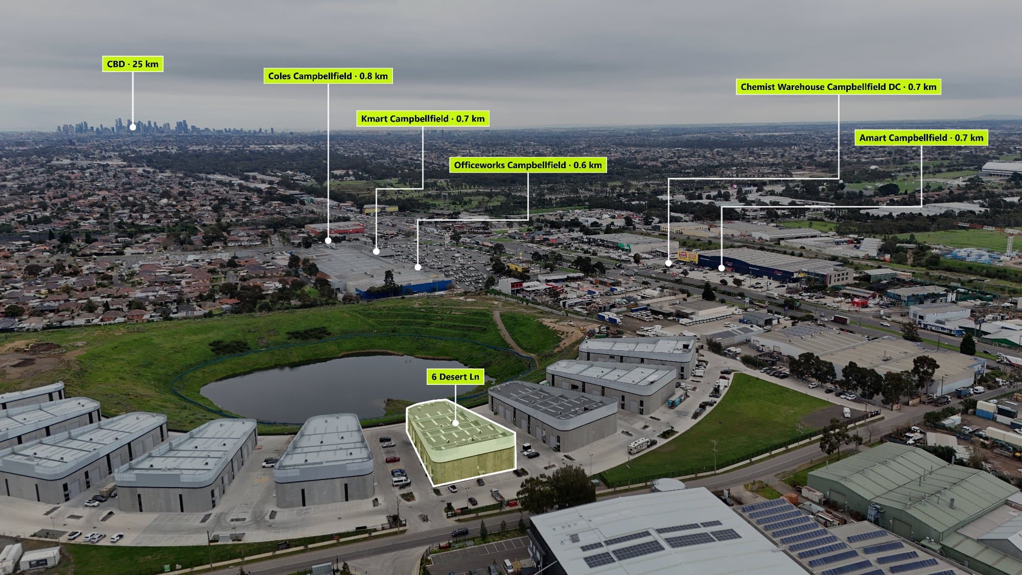
When buyers browse real estate listings, they're not just looking at the home—they're looking at the lifestyle. A stunning drone photo already provides an impressive aerial perspective, but adding Points of Interest (POIs) transforms that image into a powerful marketing tool by highlighting everything that makes the property's location valuable.
Whether you're a real estate photographer, agent, or property marketer, here's how to create engaging drone photos with interactive or annotated Points of Interest.
What Are Points of Interest?
Points of Interest (POIs) are labels or markers placed on an aerial image that identify nearby amenities such as:
- Schools
- Shopping centres
- Train stations
- Parks
- Beaches
- Hospitals
- Cafés and restaurants
- Major roads
- Sporting facilities
- Universities
Instead of leaving buyers to guess what's nearby, POIs instantly provide valuable context.
Why Use POIs on Drone Photos?
Adding location markers offers several benefits:
- Helps buyers understand the neighbourhood.
- Highlights nearby amenities without reading long descriptions.
- Makes property listings more engaging.
- Increases the perceived value of the property's location.
- Gives your real estate photography a more professional appearance.
For buyers relocating to a new suburb, a well-annotated aerial image can be one of the most useful visuals in the entire listing.
Step 1: Capture a High-Quality Drone Photo
Before adding markers, capture an aerial image that clearly shows both the property and its surroundings.
Tips:
- Shoot in good lighting (morning or golden hour works well).
- Fly high enough to include nearby landmarks.
- Keep the property centred.
- Use a level horizon.
- Export the highest resolution image possible.
The wider the view, the more useful your POI annotations become.
Step 2: Identify Nearby Amenities
Think about what matters most to potential buyers.
For example:
- Closest primary and secondary schools
- Public transport
- Shopping centres
- Medical facilities
- Parks and walking trails
- Beaches or waterfronts
- Entertainment precincts
Not every property needs the same points. A family home should emphasise schools and parks, while an apartment may focus on transport and restaurants.
Step 3: Add Clean, Professional Labels
Avoid cluttering the image with dozens of markers.
Instead:
- Use consistent icons.
- Keep labels short.
- Space markers evenly.
- Connect labels with clean lines.
- Use colours that contrast against the aerial photo.
A clean design is much easier for buyers to understand than an overcrowded image.
Step 4: Automatically Find Nearby POIs
Rather than manually searching Google Maps for every location, modern tools can automatically detect nearby amenities using the property's GPS coordinates.
This saves significant editing time while ensuring markers are positioned accurately.
Automatic POI detection is especially useful for photographers editing multiple properties each week.
Step 5: Export a High-Resolution Image
Once your annotations are complete:
- Export in full resolution.
- Ensure text remains readable.
- Check labels don't cover important parts of the property.
- Save a web-friendly version for online listings.
A crisp export looks professional across real estate portals, websites, brochures and social media.
Use AerialPin to Add POIs Faster
If you regularly create drone photography for real estate, AerialPin simplifies the entire process.
With AerialPin you can:
- Automatically detect nearby Points of Interest.
- Search thousands of nearby places instantly.
- Add professional labels with just a few clicks.
- Create clean, modern aerial annotations.
- Export high-resolution images ready for listings.
- Save hours compared to manual editing.
Whether you're editing one property or hundreds each month, AerialPin helps produce polished, informative drone images in minutes.
Visit https://www.aerialpin.com to learn more, explore the features at https://www.aerialpin.com/features, or see pricing at https://www.aerialpin.com/pricing.
Final Thoughts
Drone photography already helps listings stand out, but adding Points of Interest takes it a step further. Buyers gain a better understanding of the property's surroundings, agents receive more engaging marketing material, and photographers can offer a premium service that adds real value.
As competition in real estate marketing continues to grow, annotated drone images are quickly becoming an essential part of high-quality property listings.