
How to Add Points of Interest to Real Estate Drone Photos
Learn how to add points of interest to real estate drone photos and create professional aerial marketing images that showcase nearby amenities, schools, parks, and landmarks.
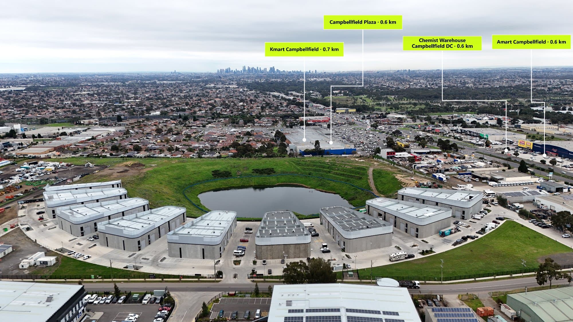
How to Add Points of Interest to Real Estate Drone Photos
Aerial drone photography has transformed the way properties are marketed online. Instead of only showing the home itself, real estate photographers can now showcase the surrounding lifestyle, nearby amenities, and location advantages from a single image.
One of the most effective ways to add value to aerial property photos is by adding points of interest (POIs).
Points of interest help buyers instantly understand what surrounds a property and why the location matters.
From schools and shopping centres to parks and transport links, annotated aerial images provide valuable context that standard drone photos cannot.
What Are Points of Interest in Real Estate Photography?
Points of interest are important locations surrounding a property that may influence a buyer's decision.
When added to an aerial drone image, these locations are displayed using professional labels, icons, and distance markers.
Common points of interest include:
- Schools
- Shopping centres
- Train stations
- Parks
- Beaches
- Sporting facilities
- Medical centres
- Restaurants
- Walking trails
- Major roads
- Local landmarks
Instead of simply telling buyers a property is "close to everything," an annotated aerial image visually proves it.
Why Add Points of Interest to Drone Photos?
Help Buyers Understand the Location
Location is one of the biggest factors in real estate.
A beautiful home can become even more appealing when buyers can immediately see:
- Nearby schools for families
- Parks and recreation areas
- Shopping options
- Transport accessibility
- Lifestyle attractions
A single aerial image can communicate more information than multiple paragraphs of property description.
Make Listings Stand Out
Real estate websites are highly competitive.
Most listings include:
- Interior photography
- Exterior photos
- Basic drone images
Adding professionally designed aerial annotations creates a premium marketing asset that immediately grabs attention.
A labelled aerial image looks more informative, more professional, and more valuable.
Improve Social Media Marketing
Aerial images with points of interest perform well across platforms because they tell a story quickly.
They are ideal for:
- Instagram posts
- Facebook property campaigns
- Builder marketing
- Development launches
- Real estate brochures
Buyers can understand the property's advantages without needing to research the area themselves.
How to Add Points of Interest to Aerial Photos
Traditionally, photographers would use a combination of tools:
- Capture drone image
- Open Google Maps
- Search nearby locations
- Screenshot locations
- Import into Photoshop
- Manually create labels
- Position lines and text
- Export final image
While this workflow works, it can take a significant amount of time for every property.
Modern aerial annotation software simplifies this process.
Using AerialPin for Drone Photo Annotations
AerialPin is designed specifically for real estate photographers who need to create professional aerial marketing images faster.
Instead of manually searching for locations and creating graphics from scratch, AerialPin helps streamline the entire annotation workflow.
With AerialPin, photographers can:
- Search nearby points of interest
- Add professional location labels
- Create property boundary overlays
- Customise branding styles
- Save annotation presets
- Export high-quality aerial images
- Process drone photography faster
Whether you're working on residential listings, luxury homes, acreage properties, or new developments, AerialPin helps turn standard drone photos into premium marketing material.
What Points of Interest Should You Include?
Not every nearby location needs to be displayed.
The best annotations focus on locations that add genuine value to the property.
Family Homes
Consider highlighting:
- Primary schools
- High schools
- Parks
- Playgrounds
- Shopping centres
- Medical facilities
Luxury Properties
Focus on lifestyle features:
- Beaches
- Golf courses
- Restaurants
- Waterfront locations
- Entertainment precincts
New Developments
Highlight:
- Future infrastructure
- Transport connections
- Shopping precincts
- Schools
- Community facilities
Tips for Professional Aerial Annotations
Keep Labels Clean
Too many labels can make an image confusing.
Focus on the most important locations and maintain a clean layout.
Use Consistent Branding
Professional photographers should maintain consistency across every project.
Consider using:
- Matching fonts
- Brand colours
- Custom icons
- Consistent spacing
This creates a recognisable style for your business.
Show Distance Information
Adding distances helps buyers quickly understand accessibility.
Examples:
- 450m to local park
- 800m to shopping centre
- 1.2km to train station
This turns a simple aerial photo into a useful property map.
Why Real Estate Photographers Are Moving Towards Automated Annotation
As clients demand more marketing value, photographers are looking for ways to deliver premium results without spending hours editing.
Automation allows photographers to:
- Reduce editing time
- Increase turnaround speed
- Offer additional services
- Create consistent results
- Scale their business
Instead of spending time manually creating every annotation, photographers can focus on capturing better images and growing their client base.
The Future of Aerial Real Estate Marketing
Aerial photography is evolving beyond simple drone images.
The future of property marketing includes:
- Automated points of interest
- Smart property mapping
- AI-assisted editing
- Interactive property visuals
- Faster content production
Tools like AerialPin are helping photographers adapt to this new workflow by making aerial annotation faster, easier, and more professional.
Conclusion
Adding points of interest to real estate drone photos is one of the best ways to increase the value of aerial imagery.
By showcasing nearby schools, parks, shopping centres, transport, and lifestyle locations, photographers provide buyers with a clearer understanding of the property's potential.
With dedicated software like AerialPin, creating professional annotated aerial images no longer needs to be a time-consuming Photoshop process.
Transform your drone photos into powerful real estate marketing assets and give buyers the complete picture.