
How to Add Points of Interest to Real Estate Drone Photos (Complete Guide 2026)
Points of interest are location markers added to aerial images that highlight important nearby places.
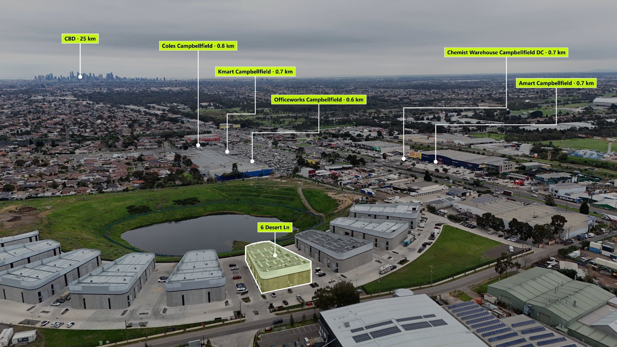
What Are Points of Interest on Drone Photos?
Points of interest are location markers added to aerial images that highlight important nearby places.
Instead of showing buyers only a property from above, you can provide valuable location information such as:
- Schools
- Childcare centres
- Shopping centres
- Train stations
- Bus stops
- Parks
- Beaches
- Restaurants
- Cafés
- Hospitals
- Universities
- Sporting facilities
- Walking trails
These markers help buyers quickly understand the lifestyle and convenience surrounding a property.
Why Add Points of Interest to Real Estate Drone Photography?
Aerial photos already provide a powerful perspective, but buyers often have questions:
"How far is the nearest school?"
"Is there public transport nearby?"
"What shops are close?"
"Is the property near parks or recreation areas?"
Adding points of interest answers these questions instantly.
Benefits include:
Improve Buyer Engagement
Listings that provide more information are easier for buyers to understand and compare.
Showcase Location Advantages
A great home is not only about the building — it's also about the lifestyle around it.
Create Premium Marketing Material
A labelled aerial map gives listings a more professional and complete presentation.
Help Buyers Make Faster Decisions
Clear location information reduces uncertainty and helps buyers visualise living in the area.
Traditional Way to Create Aerial Maps
Many real estate photographers manually create point-of-interest maps using multiple tools.
The traditional workflow:
- Capture drone images
- Export photos
- Open Google Maps
- Find nearby locations
- Screenshot maps
- Design markers in Photoshop
- Position labels manually
- Export the final image
This process can take 20–60 minutes depending on the number of locations required.
For photographers managing multiple property shoots every week, this quickly becomes a time-consuming task.
The Faster Way: Using AerialPin
AerialPin was built specifically for real estate photographers who want to create professional aerial property images faster.
The workflow is simple:
1. Upload Your Drone Photo
Upload your aerial image and AerialPin reads the location information from compatible drone images.
2. Find Nearby Locations
Search nearby amenities including:
- Schools
- Parks
- Shopping centres
- Transport
- Landmarks
3. Add Custom Markers
Place professional labels directly onto your aerial image.
4. Export Your Final Image
Create a high-resolution image ready for:
- Realestate.com.au
- Domain
- Property brochures
- Social media marketing
- Agency presentations
What Information Should You Include on a Property Aerial Map?
Not every nearby location needs to be displayed.
The best aerial maps focus on locations buyers actually care about.
Family Buyers
Highlight:
- Schools
- Childcare
- Parks
- Sporting facilities
Professionals
Highlight:
- Train stations
- Cafés
- Restaurants
- CBD access
Lifestyle Buyers
Highlight:
- Beaches
- Walking trails
- Golf courses
- Recreation areas
The goal is to tell the property's lifestyle story.
Tips for Creating Professional Looking Aerial Maps
Keep Labels Clean
Avoid overcrowding the image with too many markers.
Focus on the most valuable locations.
Use Consistent Branding
Match your colours, fonts and style with your photography brand or agency.
Choose the Right Perspective
Aerial images should clearly show:
- Property boundaries
- Roads
- Surrounding areas
- Nearby landmarks
Make Distance Clear
Including approximate distances helps buyers quickly understand proximity.
Why Real Estate Photographers Should Offer Aerial Maps
Adding aerial point-of-interest images creates an opportunity to provide a premium service.
Photographers can:
- Increase package value
- Differentiate from competitors
- Offer better marketing solutions
- Create additional revenue streams
- Deliver more value to real estate agents
Instead of only delivering drone photos, photographers can provide a complete location marketing package.
Frequently Asked Questions
How do you add points of interest to drone photos?
Professional photographers can use software like AerialPin to automatically find nearby locations and add custom markers directly onto aerial images.
Can DJI drone photos show location information?
Yes. Many DJI drones store GPS metadata inside image files, which can be used to identify where the photo was taken.
Do real estate agents use aerial maps?
Yes. Aerial maps help agents showcase a property's location, nearby amenities and lifestyle benefits.
Can I create aerial maps without Photoshop?
Yes. Tools like AerialPin allow photographers to create professional aerial images without manually designing everything in Photoshop.
Final Thoughts
Real estate drone photography is no longer just about showing a property from above. The best aerial marketing tells the complete story — the home, the neighbourhood and the lifestyle.
By adding points of interest to drone photos, photographers can create more valuable property marketing assets that help buyers understand a listing faster.
Create professional real estate aerial maps in minutes with AerialPin and take your drone photography workflow to the next level.