
How to Add Property Boundaries to Drone Photos
Learn how to add property boundaries to drone photos and aerial images. Property boundary overlays can help real estate agents, drone operators, developers and land sellers clearly show the area of a property, development site or parcel of land directly on an aerial photograph.
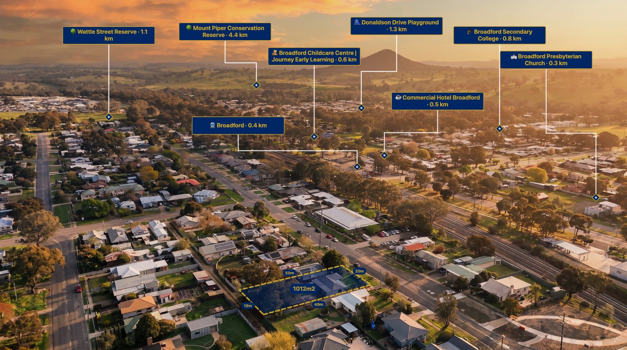
Drone photography is one of the easiest ways to show a property from above. It can reveal the size of a block, surrounding roads, neighbouring properties and nearby development that isn't always obvious from ground-level photos.
However, aerial photographs don't always make property boundaries clear.
When you're marketing land, a development site or a large property, adding a boundary overlay can make the image much easier to understand.
In this guide, we'll look at how to add property boundaries to drone photos and how AerialPin can help.
Why Add Property Boundaries to Aerial Photos?
A drone photograph shows what's physically visible from above, but it doesn't necessarily show where a property's legal or marketed area begins and ends.
A boundary overlay gives the viewer a visual reference.
For example, an aerial image of a vacant block might show several neighbouring blocks. Without a boundary, it may not be immediately obvious which one is being sold.
Adding a boundary can make the marketed area stand out.
Property boundaries can be useful for:
- Vacant land
- Development sites
- Acreage properties
- New residential estates
- Subdivision projects
- Commercial properties
- Land sales
- Property presentations
What Is a Property Boundary Overlay?
A property boundary overlay is a visual line placed over an aerial photograph to indicate the outline of a property or site.
The underlying aerial image remains visible while the boundary makes the relevant area easier to identify.
A typical annotated aerial image might contain:
Property boundary
Location pins
Nearby roads
Distance measurements
Text labels
This can turn a standard drone photo into a more informative property marketing image.
How to Add a Property Boundary to a Drone Photo
1. Capture Your Aerial Image
Start with a clear drone photograph showing the property from above.
A higher-altitude image can sometimes make the surrounding area easier to understand, while a lower-altitude image can provide more detail.
If your drone image contains GPS information, keep the original file.
2. Upload the Image
Open AerialPin and upload your aerial photograph.
AerialPin is a browser-based tool designed for annotating aerial and drone photography.
3. Add the Property Boundary
Once your aerial image is loaded, you can add a boundary overlay around the area you want to highlight.
The boundary should follow the relevant property or development site as closely as the source information allows.
The goal is to make the marketed area immediately visible without hiding the aerial photography underneath.
4. Add Location Information
Once you've added the boundary, you can add additional information around the site.
For example, you might highlight:
- Nearby schools
- Shopping centres
- Parks
- Train stations
- Major roads
- Sporting facilities
AerialPin Nearby Search can help you find nearby locations to add to the image.
5. Add Measurements
You can also add distance measurements to show how far the property is from important surrounding locations.
For example:
600 m to School
900 m to Shopping Centre
1.3 km to Train Station
This can give potential buyers additional context about the property's location.
Property Boundaries for Real Estate Marketing
Real estate agents can use boundary overlays to make aerial property photography more informative.
This can be particularly useful for larger properties where the boundaries aren't obvious from the photograph.
For example, an aerial image of an acreage property could show the entire property outline while also identifying nearby roads and amenities.
The same concept can be used for residential blocks and larger development sites.
Property Boundaries for Land Developers
Developers often need to communicate the size and position of a development site.
An annotated drone photograph can provide a simple visual way to show the site in relation to the surrounding area.
You could highlight:
- Development boundaries
- Existing roads
- Future access
- Nearby estates
- Parks
- Schools
- Commercial areas
- Infrastructure
This can be useful for marketing and project presentations.
Adding Boundaries to Vacant Land
Vacant land can be particularly difficult to understand from an aerial photograph.
A drone image may show several empty blocks or large areas of undeveloped land.
A boundary overlay immediately draws attention to the relevant site.
This makes the aerial image more useful for land listings and development marketing.
Combine Boundaries With Location Pins
A property boundary becomes even more useful when combined with location pins.
For example:
Property Site
↓
800 m Shopping Centre
↓
1 km School
↓
1.4 km Train Station
This gives the viewer a visual overview of both the property and its surrounding amenities.
Add Custom Text
Not everything you need to communicate will come from a property boundary or location search.
You can also add custom text to identify areas within the photograph.
For example:
- Proposed Development
- Future Stage
- Access Point
- Open Space
- Existing Homes
- Commercial Precinct
AerialPin includes text and annotation tools for adding this type of information.
Use AI Auto Place
If you're creating a large number of annotated aerial images, manually adding locations to each image can become repetitive.
AerialPin AI Auto Place can help identify and place relevant nearby locations using available geographic and camera information.
This can help speed up the process when preparing property marketing images.
Make the Boundary Easy to See
A boundary needs to be visible without overpowering the photograph.
When creating a property marketing image, consider:
- Keeping the boundary clear
- Avoiding unnecessary annotations
- Leaving the property itself visible
- Using short labels
- Showing only relevant nearby locations
The purpose of the overlay is to make the property easier to understand.
Property Boundaries and GPS Data
Drone photographs often contain GPS coordinates within their EXIF metadata.
This information can help establish where the photograph was captured and can be useful when working with geographic annotations.
However, GPS coordinates and cadastral property boundaries are not the same thing.
A drone's GPS location tells you where the camera was when the photograph was taken. It doesn't automatically provide the legal property boundary.
For accurate property boundaries, you should use the appropriate cadastral, title, survey or GIS data for the property and verify the information before using it for legal or professional purposes.
What If Your Drone Photo Lost Its GPS Data?
Editing and exporting a drone photograph can sometimes remove EXIF metadata.
If you still have the original drone image, AerialPin's EXIF tools can help you work with the original GPS and camera information.
It's a good idea to keep the original drone photographs alongside edited versions.
Add 360 Property Boundaries
AerialPin also supports 360 aerial photography.
You can stitch multiple drone photographs into a panorama and annotate the resulting 360 image using the panorama viewer.
The 360 panorama functionality is currently in beta.
This can provide another way to present larger properties and development sites.
Create Better Aerial Property Marketing Images
Aerial photography already provides a useful view of a property, but adding a boundary can make the image much easier to understand.
Whether you're marketing vacant land, an acreage property, a residential block or a development site, showing the property outline can provide valuable visual context.
With AerialPin, you can combine property boundaries with location pins, measurements, labels and other aerial photography tools in one browser-based workflow.
Try AerialPin and start creating annotated property images.