
How to Add Property Boundaries to Real Estate Photos
Learn how to show property boundaries on aerial real estate photos. Discover how to outline land, highlight vacant blocks and create better property marketing images.
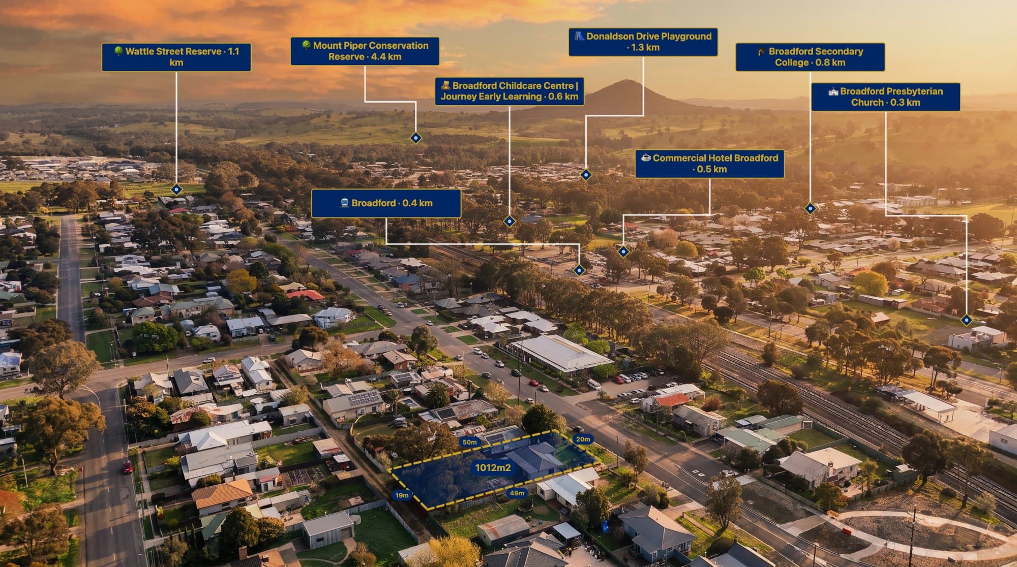
When marketing land, acreage or development sites, buyers often want to understand exactly what they are looking at.
A standard aerial photograph can show the property from above, but it may not clearly communicate where the land begins and ends.
Adding property boundary outlines to aerial photographs makes the image easier to understand and can help real estate agents present land more effectively.
Why show property boundaries on aerial photos?
Property boundary annotations can help communicate:
-
The approximate shape of a property.
-
The land area being marketed.
-
The relationship between the property and surrounding roads.
-
Access points and nearby infrastructure.
-
The location of existing buildings.
-
The layout of larger parcels of land.
This is especially useful for vacant land, rural properties, acreage and development opportunities.
How to add property boundaries to a real estate photo
Step 1: Choose a suitable aerial photograph
Start with an aerial image that clearly shows the property and surrounding area.
A slightly angled aerial image can look attractive for marketing, while a more directly overhead image can make it easier to understand the property's layout.
Step 2: Obtain the correct boundary information
Before drawing a boundary, identify the correct land parcel using reliable property information.
Depending on the location, this may involve cadastral mapping, survey plans, government property mapping services or other authorised geographic information.
Remember that GPS information embedded in a drone photograph identifies where the photograph was taken. It does not automatically identify the legal parcel boundary.
Step 3: Draw the property outline
Upload the photograph to an annotation tool and create an outline around the property.
Adjust the points to follow the verified boundary information as closely as the image perspective allows.
For angled aerial photographs, account for perspective distortion. A boundary that looks correct on a map may need careful positioning on the photograph.
Step 4: Customise the boundary style
Use a colour that stands out without covering important property details.
Common design choices include:
-
Solid outlines.
-
Dashed boundary lines.
-
Semi-transparent shaded areas.
-
Highlighted property corners.
-
Labels showing land size.
A subtle fill combined with a clear outline often works well.
Step 5: Add supporting information
Consider adding labels for:
-
Property access.
-
Existing structures.
-
Nearby roads.
-
Development areas.
-
Important surrounding features.
Keep annotations relevant to the buyer.
How AerialPin helps with property boundary annotations
AerialPin allows users to upload aerial imagery and add or customise property boundary outlines directly in the browser.
You can combine boundaries with location pins, labels, distance measurements and other annotations to create a more informative property marketing image.
Visit AerialPin to explore the editor.
Important: Are aerial property boundaries legally accurate?
An annotated aerial image should not automatically be treated as a legal survey or cadastral plan.
Visual boundary overlays are useful for marketing and general presentation, but their accuracy depends on the source data, image perspective, positioning and verification process.
If exact legal boundaries are required, consult a registered land surveyor or the relevant authoritative property records.
Frequently asked questions
Can I draw property boundaries on a drone photo?
Yes. You can use an image annotation tool to draw and customise boundary outlines.
Can drone GPS automatically find property boundaries?
No. Drone GPS metadata can help identify the photograph's location, but it does not contain the legal boundaries of the surrounding land parcels.
How do I show vacant land boundaries to buyers?
Use a clear aerial photograph with a verified boundary outline, a land-size label and relevant surrounding location information.
Can I highlight multiple properties in one aerial photo?
Yes. Multiple outlines and labels can be used to distinguish neighbouring lots or different land parcels.