
How to Add Property Boundary Lines to Drone Photos
Learn how to add clean, professional property boundary lines to aerial drone photos for real estate marketing, including how AerialPin can help you create boundaries, labels and nearby point-of-interest annotations faster.
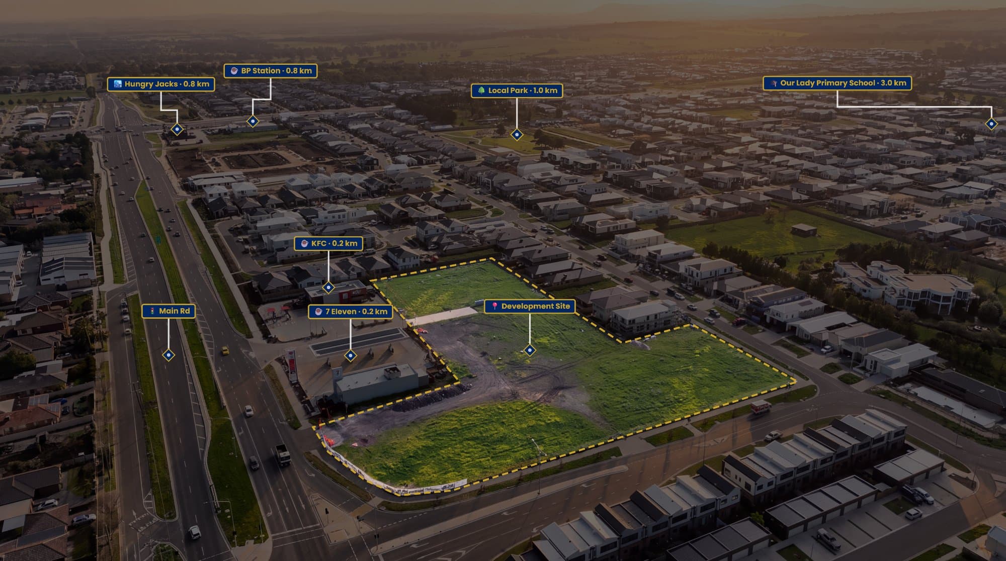
Aerial property photos look great, but there’s one thing they often don’t show very well: where the property actually ends.
You can have a beautiful drone shot of a house, backyard and surrounding streets, but unless there’s an obvious fence, it can be difficult for someone looking at the image to know exactly which piece of land they're looking at.
That’s why property boundary lines have become so useful in real estate marketing.
A simple outline around the block can completely change how an aerial image is understood.
What Does a Property Boundary Line Look Like?
You’ve probably seen these types of images before.
A drone photo shows the property from above, with a clean line following the edges of the block. Sometimes the inside of the property is lightly shaded, with a label showing the land being sold.
It’s a simple addition, but it gives the viewer an immediate reference point.
This is particularly useful for properties with large backyards, corner blocks, acreage, vacant land or development potential.
Instead of trying to work out which fence belongs to which property, the buyer can see the intended property area straight away.
The Old Way of Doing It
For a long time, the easiest option was to open the drone photo in Photoshop and draw the boundary yourself.
You'd find a property map, compare it with your aerial photo, create a new layer and start tracing.
Then comes the fiddling.
Move a point.
Zoom in.
Move another point.
Change the line thickness.
Add some transparency.
Add the property label.
Export it.
If you're doing this once, it's not a huge deal.
If you're a real estate photographer doing this for multiple properties every week, it gets old pretty quickly.
The biggest issue isn't necessarily drawing the line. It's getting all of the information together and making the final image look consistent.
AerialPin Makes This Part Easier
This is one of the reasons I built AerialPin.
AerialPin is designed around aerial property photography rather than being a general image editor.
You can upload your drone image, create the property boundary directly over the photograph and customise how you want it to look.
You can control things like the boundary line, fill, transparency and labels without having to build the graphic from scratch every time.
The idea is pretty simple: take the drone photo you already have and turn it into a more useful marketing image.
Don't Stop at the Property Boundary
Once you start adding information to an aerial photo, you can do a lot more than just outline the block.
Think about what a buyer actually wants to know when they're looking at a property from above.
Where's the park?
How far away is the shopping centre?
Which direction is the train station?
What's around the property?
These are all things that can be shown directly on the aerial image.
AerialPin can use the GPS information stored in compatible drone photos to help identify nearby points of interest. You can then add those locations to the image alongside the property boundary.
The result is less like a standard drone photograph and more like a visual guide to the property and its surroundings.
What About Automatically Placing the Pins?
This is another part of the process that can take longer than you'd expect when doing everything manually.
Finding the location is one thing. Working out where that location should appear in an angled aerial photograph is another.
AerialPin's AI Auto Place is designed to handle that part.
It uses information from the drone image to help determine where nearby locations sit within the photograph, then places the pins accordingly.
So instead of manually guessing where a park or shopping centre should go on the image, you can have the software do the positioning for you and make adjustments if needed.
A Few Things to Keep in Mind
There is one important thing to remember when adding property boundaries to marketing images.
A line on a drone photo isn't a substitute for a land survey.
Property data can change, mapping sources can differ and what looks like a boundary from the air isn't necessarily the legal boundary.
For real estate marketing, the purpose is to give the viewer a clear visual representation of the property.
If you're dealing with a situation where exact legal measurements or boundaries are required, use the appropriate cadastral or survey information and get professional advice where necessary.
Make the Image Useful, Not Just Pretty
Drone photography already does a great job of making a property look impressive.
But the best aerial marketing images do more than look good.
They help someone understand the property.
A boundary line shows the land.
A label identifies the property.
A few well-chosen points of interest show what's nearby.
Suddenly, the same drone photo tells a much bigger story.
And you don't need to cover the image with information to achieve that. In most cases, keeping it simple looks much more professional.
Give It a Try
If you're regularly creating aerial images for real estate listings, manually building every boundary graphic can become another job in itself.
AerialPin was built to make that process quicker, while also giving photographers tools for property boundaries, labels, nearby places and automatic placement.
Upload your drone photo, mark the property and build the image from there.
Try AerialPin and see how much easier it is to turn a standard drone photo into a property marketing image.