
How to Add Spotlight & Boundary Lines to Drone Images
Learn how to add clean spotlight effects and property boundary lines to drone images, helping real estate photographers make properties stand out and give buyers a clearer view of the land.
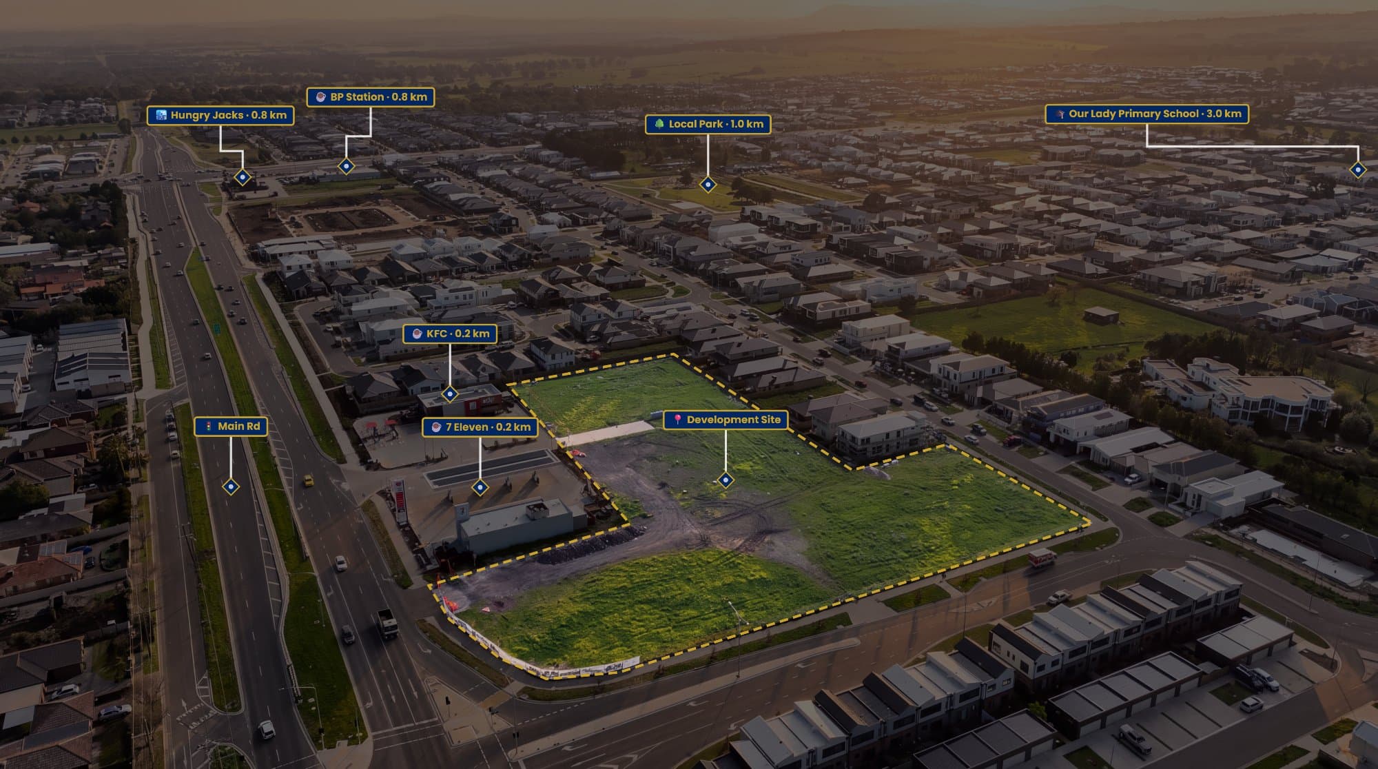
Drone images are great for showing a property from a completely different perspective.
But when you're looking at a large aerial photograph, it isn't always immediately obvious which property you're supposed to be looking at.
That's where spotlight effects and boundary lines can make a big difference.
A simple outline can show the exact property, while a subtle spotlight effect can draw attention to the home and land without ruining the original photograph.
What Is a Property Spotlight?
A property spotlight is a simple visual effect that makes the subject property stand out from everything around it.
Instead of changing the photograph itself, you can darken or soften the surrounding area while keeping the property brighter and more visible.
This works particularly well when the property is surrounded by similar-looking homes, large blocks of land or busy suburban streets.
The viewer's attention naturally moves towards the highlighted property.
Adding a Property Boundary
The next step is adding a boundary line around the property.
You'll need a reliable property boundary reference before drawing the line. Property mapping, cadastral information or other appropriate property data can be used to identify the corners of the block.
Once you have the reference, you can trace the boundary over the drone image.
The line doesn't need to be complicated. A clean, consistent outline is usually enough to show the viewer where the property starts and ends.
Doing It Manually
The traditional way to create this type of graphic is with Photoshop.
You can create a new layer, trace the property boundary with the pen tool and then create another layer for the spotlight effect.
You can lower the opacity around the property, adjust the boundary line and add any labels you need.
The end result can look great, but the process can take time.
If you're producing aerial marketing images regularly, repeating the same steps for every listing isn't ideal.
AerialPin Makes It Easier
AerialPin is designed specifically for annotating aerial property photographs.
Instead of building the entire graphic manually, you can upload your drone image and create the property boundary directly over it.
You can adjust the boundary style, add a fill and use a spotlight effect to make the property stand out from the surrounding area.
This makes it much easier to create a consistent look across your real estate photography.
Add Labels and Nearby Locations
Once the property is highlighted, you can add additional information to the image.
For example, you might want to show:
- Local schools
- Parks
- Shopping centres
- Train stations
- Beaches
- Sporting facilities
These can help give potential buyers a better understanding of where the property sits within the surrounding area.
AerialPin AI Auto Place can also help position nearby points of interest on compatible drone photographs using information from the image.
This means you can create an aerial graphic that shows the property, its boundary and what's nearby without manually building everything from scratch.
Keep the Spotlight Subtle
One of the biggest mistakes with a spotlight effect is making it too strong.
You don't want the surrounding properties to disappear completely.
The goal is simply to create enough contrast for the subject property to stand out.
A subtle darkening around the property usually looks much more professional than a heavy effect.
The same applies to the boundary line. Make it visible, but don't let it dominate the photograph.
A Better Way to Present Aerial Photography
A drone photograph already gives buyers a useful view of a property.
Adding a boundary and spotlight turns that photograph into something more informative.
The viewer can immediately see:
Which property is being advertised.
Where the property boundaries are.
What's located around it.
And all of that information can be communicated without needing a separate map.
If you're creating aerial marketing images for real estate, AerialPin gives you a faster way to create property outlines, spotlight effects, labels and nearby points of interest in one workflow.
Try AerialPin and turn your next drone image into a more useful property marketing graphic.