
How to Add Text and Labels to Drone Photos
Learn how to add clear text and labels to drone photos for real estate marketing, property developments and land sales. Turn a standard aerial image into an easy-to-understand graphic by highlighting roads, parks, boundaries, developments and nearby locations.
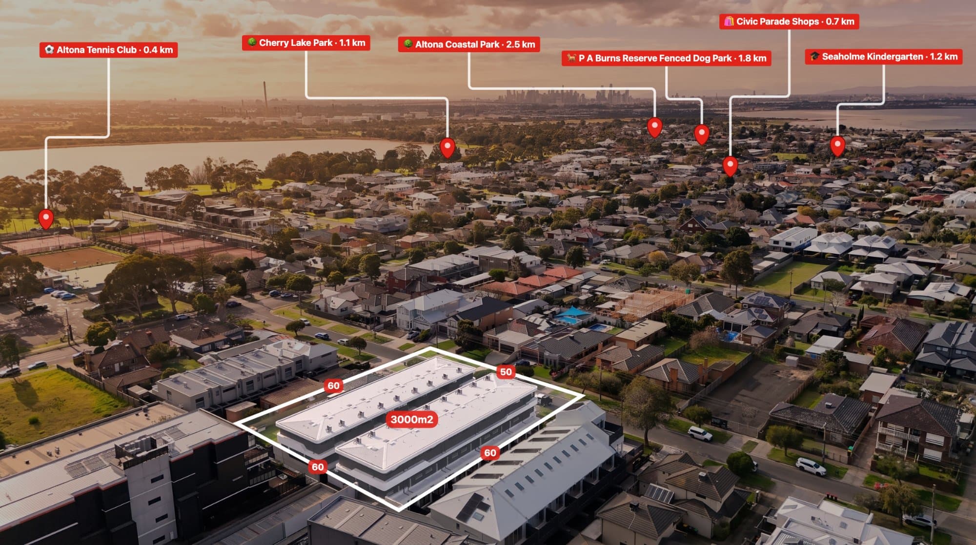
Adding text and labels to drone photos is a simple way to give an aerial image more context.
A standard drone photo can show an entire property and its surroundings, but viewers may not immediately know what they are looking at. Adding a few clear labels can make the important information obvious.
This is especially useful for real estate agents, drone operators, property photographers, developers and land sellers.
Why Add Text to Drone Photos?
Aerial photography gives you a unique view of a property, but the surrounding area can sometimes be difficult to understand.
Text labels can identify important features directly on the image.
For example, you could label:
- Main roads
- Parks
- Schools
- Shopping centres
- Beaches
- Train stations
- Property boundaries
- Development sites
- Access roads
- Neighbouring properties
Instead of relying on a long description, the information is visible directly on the aerial photograph.
How to Add Labels to a Drone Photo
The process is straightforward.
1. Upload your aerial photo
Start with a high-resolution drone photograph.
Choose an image where the property and surrounding locations you want to highlight are clearly visible.
2. Decide what needs to be labelled
Before adding text, work out what information will actually help the viewer.
For a residential property, this might be a nearby park, school or major road.
For a development site, you may want to show the site boundary, access road and proposed development area.
3. Add your text
Place a short label next to the relevant feature.
For example:
MAIN ROAD
LOCAL PARK
SHOPPING CENTRE
DEVELOPMENT SITE
PROPERTY BOUNDARY
Short labels are generally easier to read than long descriptions.
4. Position the labels
Move the text so it doesn't cover important parts of the photograph.
You can use lines or pins to connect the label to the exact location when necessary.
5. Export the finished image
Once you're happy with the annotations, export the image for your property listing, social media, website, brochure or presentation.
Use Labels With Location Pins
Text becomes even more useful when combined with location pins.
A pin can identify the exact point while the label tells the viewer what it is.
For example:
📍 PARK
📍 TRAIN STATION
📍 BEACH
📍 SHOPPING
This creates a simple visual guide around the property.
AerialPin lets you add location pins, text, measurements and other annotations directly to aerial photography.
Find Nearby Locations
You don't always need to manually search for every nearby location.
AerialPin Nearby Search can help find places around the property that you can use when creating your aerial marketing graphic.
You can then choose the locations that are actually relevant and label them on the image.
Automatically Place Locations With AI
If you're annotating a large number of drone photos, manually finding and placing locations can become repetitive.
AerialPin AI Auto Place can use information from the drone image, including GPS and camera data, together with nearby places to help automatically place relevant locations.
You can review the results before exporting the final image.
Add Property Boundaries
Labels can also be used with property boundary overlays.
For example, an aerial image could show:
SITE BOUNDARY
ACCESS
PROPOSED LOTS
FUTURE DEVELOPMENT
This can make large blocks of land and development sites much easier to understand.
Keep in mind that drone GPS coordinates are not the same as official cadastral boundaries. For accurate property information, use appropriate survey, cadastral or GIS data.
Add Distance Measurements
Another useful addition is distance information.
You could show:
400 m TO PARK
800 m TO SHOPS
1.1 km TO SCHOOL
Combining a location pin, label and measurement can communicate a property's surroundings very quickly.
How to Make Labels Look Professional
You don't need complicated graphic design.
Simple labels usually work well on aerial photography.
Try to keep:
- Font sizes consistent
- Labels short
- Spacing clean
- Lines easy to follow
- Text readable
- Important areas unobstructed
Avoid placing large amounts of text over buildings or other important parts of the image.
The aerial photograph should remain the main focus.
Don't Overload the Image
One of the biggest mistakes with aerial annotations is adding too much information.
If every road, building and location has a label, the image can become difficult to read.
Instead, focus on the locations that actually matter.
For a residential listing, three to five key locations may be enough.
For a large development or land sale, more annotations may be appropriate.
Labels for Property Developers
Developers can use annotated drone photography to communicate site information that isn't obvious from a normal property photo.
For example, you could label:
- Existing buildings
- Proposed lots
- Roads
- Access points
- Open space
- Development stages
- Nearby infrastructure
- Site boundaries
This can turn a simple drone photograph into a useful visual presentation.
Labels for Real Estate Marketing
Annotated aerial photography can also work well on social media.
Instead of posting a standard aerial image, you can use labels to highlight the property's location and surroundings.
For example:
NEXT TO PARK
5 MIN TO SHOPS
CLOSE TO TRAIN STATION
LARGE DEVELOPMENT SITE
The graphic can communicate the main selling points while someone is scrolling through a feed.
Browser-Based Drone Photo Annotation
You don't always need Photoshop or a complicated design application to add text to an aerial photograph.
A browser-based annotation tool can be faster when your goal is simply to upload a drone image, add information and export it.
AerialPin is built specifically around aerial photo annotation, making it possible to work directly on the drone image and add locations, boundaries, measurements and text in one workflow.
Final Thoughts
Adding text and labels to drone photos is a simple way to make aerial photography more informative.
Whether you're highlighting nearby amenities, property boundaries, development sites or distances, a few well-placed annotations can completely change how easy an aerial image is to understand.
For real estate agents, drone operators, photographers and developers, the key is keeping the information clear, useful and easy to read.