
How to Annotate Aerial Photos for Real Estate
Learn how to annotate real estate aerial photos with property boundaries, nearby locations, GPS data, labels and AI pin placement using AerialPin.
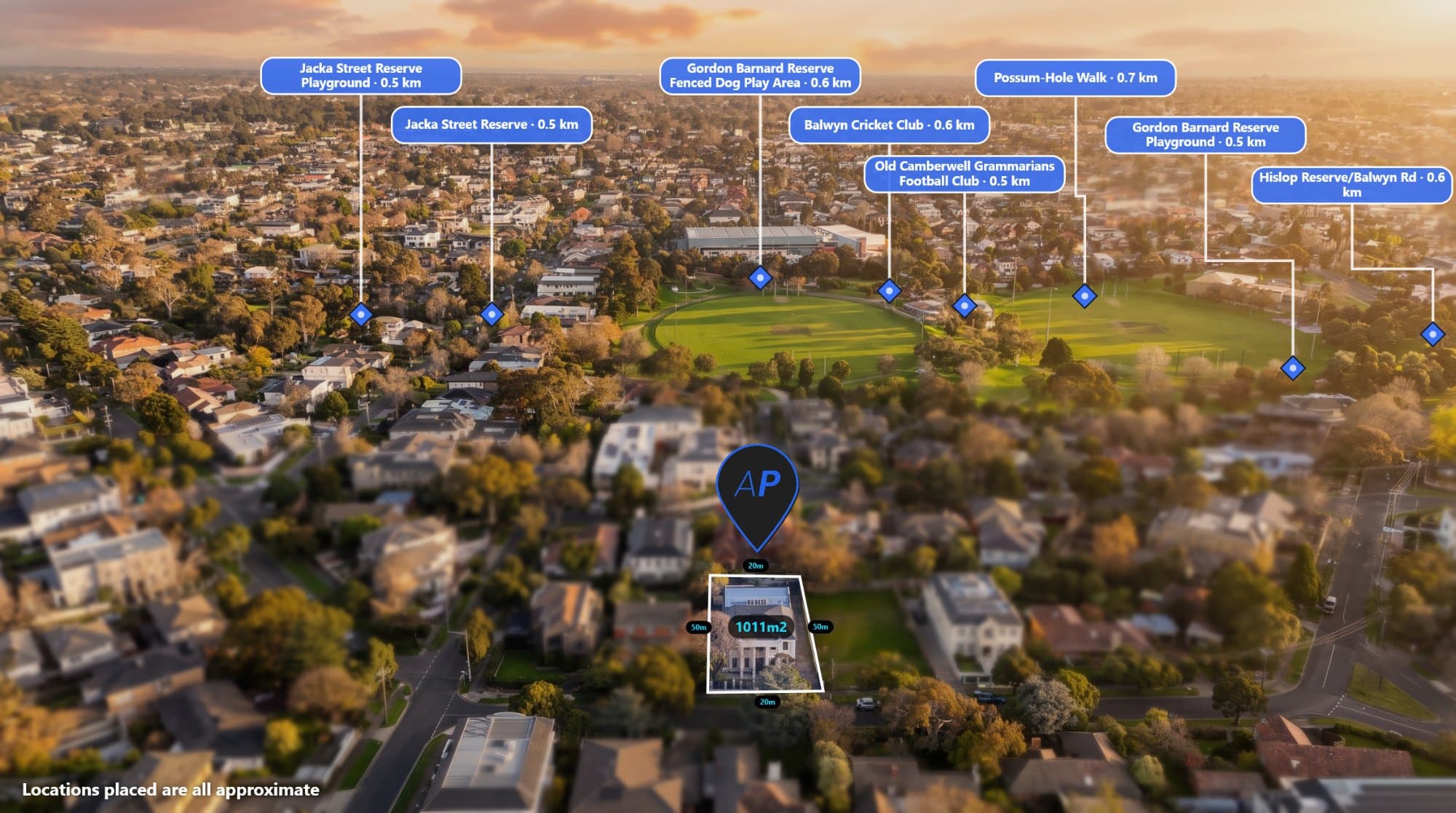
Aerial photography has become an important part of modern real estate marketing.
A good drone photo can show the property, surrounding streets, nearby amenities and the overall location in one image. But adding useful information to that photo can make it even more effective.
This is known as aerial photo annotation.
For real estate photographers, annotation can include property boundaries, nearby schools, shopping centres, parks, transport, distances, labels and custom pins.
The challenge is creating these annotations quickly while keeping the final image professional.
AerialPin is designed to make that process easier.
What Is Aerial Photo Annotation?
Aerial photo annotation means adding information directly onto an aerial image.
For a real estate property, you might annotate:
- Property boundaries
- Schools
- Shopping centres
- Parks
- Train stations
- Roads
- Beaches
- Sporting facilities
- Local landmarks
- Distances
- Custom text
Instead of making buyers work out where everything is themselves, the information is presented directly on the photograph.
This can turn a simple drone image into a more informative property marketing asset.
Why Annotate Real Estate Drone Photos?
Aerial photographs are particularly useful because they show more than the property itself.
They show the surrounding area.
For example, a buyer might care about how close a property is to a school or shopping centre.
Rather than simply saying:
"Close to local amenities"
an annotated aerial image can show:
Primary School 450m
Shopping Centre 800m
Train Station 1.1km
The information becomes visual and immediately understandable.
Start With Your Original Drone Photo
The best place to start is usually the original JPEG or DNG straight from your drone.
That's because drone images can contain important EXIF metadata.
This can include:
- GPS coordinates
- Altitude
- Compass heading
- Gimbal angle
- Camera model
- Focal length
- Shutter speed
- Aperture
- ISO
AerialPin's Drone EXIF & GPS Data tool lets you inspect this information directly.
The tool can help you check whether your photograph contains the GPS and camera information required for automated annotation.
Why Drone GPS Data Matters
GPS coordinates can tell you where your drone was when the photograph was taken.
This is particularly useful when adding nearby locations.
Instead of manually entering the property address, the photograph itself can provide the starting location.
AerialPin can read GPS information from supported drone photographs and use it for other tools within the platform.
This means the workflow can start with the image itself.
Find Nearby Locations
Once the location of the aerial photograph is known, you can search for nearby places.
AerialPin Nearby Search lets you search for useful points of interest around the property.
You can choose categories such as:
- Schools
- Universities
- Parks
- Shopping centres
- Supermarkets
- Train stations
- Transport
- Cafes
- Medical facilities
- Sports grounds
You can also choose how far around the property you want to search.
The results include the distance from the property, allowing you to select the locations that are actually useful for the listing.
Don't Add Every Location
More labels don't necessarily mean a better aerial image.
A good real estate aerial image should communicate information without becoming difficult to read.
Instead of adding 20 different locations, focus on the places that matter most to buyers.
For example:
Property
Nearest school
Nearest shopping centre
Nearest transport
Major park
That's often enough to communicate the location effectively.
Automatically Place Your Pins
Once you've selected the locations you want to show, you need to position them on the aerial photograph.
This can be done manually, but it can also be automated.
AerialPin AI Auto Place uses the GPS position, compass heading and gimbal angle stored in the drone photograph to work out which nearby places the camera can actually see.
It then positions the relevant pins on the image.
This means you're not simply placing locations on a generic map.
The system is using the drone photograph and its camera information to determine where the locations belong within the actual image.
You can then review the result and move, rename, restyle or remove pins as needed.
Add the Property Boundary
Another important annotation for real estate aerial photography is the property boundary.
A boundary makes it clear which part of the aerial image represents the property being marketed.
This is particularly useful for:
- Acreage
- Large blocks
- Development sites
- Vacant land
- Rural properties
- Commercial properties
You can combine the boundary with nearby locations to create a complete overview of the property and its surroundings.
Make Your Annotations Match Your Brand
Aerial annotations don't have to look generic.
Professional photographers and agencies can create a consistent visual style across their listings.
AerialPin Styles allows you to customise the appearance of your annotations.
You can adjust:
- Pin shapes
- Pin colours
- Fonts
- Label sizes
- Backgrounds
- Borders
- Leader lines
- Property boundaries
- Spacing
You can then save the style as a template and reuse it on future property images.
This is useful if you want every aerial image you deliver to have the same professional appearance.
What About Overcast Drone Photos?
Sometimes you capture the perfect composition but the weather isn't ideal.
The property might look great from above, but the sky could be grey or flat.
AerialPin AI Relight can create different lighting versions of the same aerial photograph.
You can generate:
- Bright day
- Golden hour
- Twilight
- Clear sky
The tool is designed to change the sky and lighting while keeping the existing property and scene intact.
This means you can create different marketing looks without needing to return to the property for another drone flight.
A Complete Aerial Annotation Workflow
For a real estate photographer, the workflow can look like this:
1. Capture the aerial photo
Take your property photographs with your drone.
2. Check the metadata
Use EXIF Info to check the GPS coordinates, altitude, heading and gimbal information.
3. Search for nearby places
Use Nearby Search to find schools, parks, shopping, transport and other important locations.
4. Automatically place the pins
Use AI Auto Place to position the relevant locations on the aerial image.
5. Add the property boundary
Mark the property being marketed so buyers can clearly understand the land shown in the image.
6. Apply your branding
Use Styles to create a consistent look for your annotations.
7. Create an alternative lighting version
Use AI Relight if you want a different sky or time-of-day look.
8. Export the finished image
Your aerial photograph is now ready for the property listing, brochure, website or social media.
Why Real Estate Photographers Are Using Aerial Annotations
Aerial annotation can add another layer of information to your photography.
Instead of simply delivering:
"Here's the drone photo."
you can deliver:
"Here's the property, its boundary, the nearby amenities and the important locations around it."
That makes the image more useful to the agent and potentially more useful to the buyer.
It can also give photographers an additional service they can offer as part of their real estate photography packages.
Save Time on Every Property
The biggest advantage of an automated aerial annotation workflow is the time saved.
You don't need to manually search for every location.
You don't need to manually position every pin.
You don't need to recreate your annotation style every time.
And you can check the drone's metadata without opening a separate EXIF application.
AerialPin brings these steps together into one workflow.
Create Better Real Estate Aerial Images
Aerial photography already gives buyers a unique view of a property.
Adding the right information can make that view even more useful.
With GPS data, nearby locations, automatic pin placement, property boundaries, custom styles and AI relighting, you can turn a standard drone photograph into a complete property marketing image.
If you're a real estate photographer looking for a faster way to annotate aerial photos, try AerialPin.
Your drone captured the view. AerialPin helps you add the context.