
How to Annotate Drone Photos Online
Learn how to annotate drone photos online with location pins, property boundaries, measurements and labels. AerialPin lets real estate photographers, drone operators and property marketers turn raw aerial images into informative marketing photos directly in the browser.
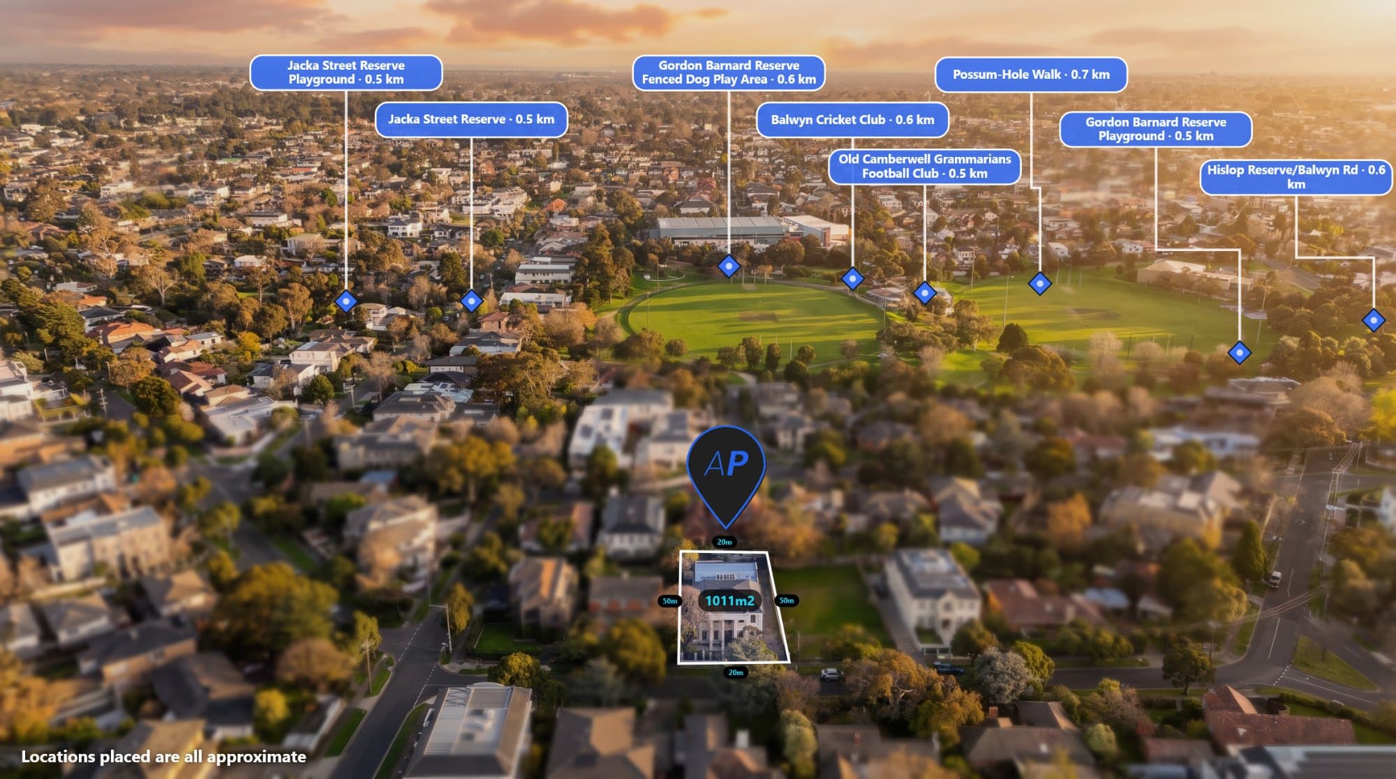
Drone photos are a great way to show a property, development site or piece of land from above. But sometimes a raw aerial photo doesn't show enough information on its own.
Adding labels, locations, boundaries and measurements can make the image much easier for clients and potential buyers to understand.
The good news is that you don't need complicated desktop software to annotate a drone photo. Browser-based tools such as AerialPin allow you to upload an aerial image and add annotations directly online.
What Does Drone Photo Annotation Mean?
Drone photo annotation is the process of adding useful information to an aerial photograph.
Depending on what you're trying to show, this could include:
- Location pins
- Nearby businesses
- Schools and parks
- Property boundaries
- Distance measurements
- Roads
- Text labels
- Development areas
- Points of interest
For real estate photography, these annotations can help give potential buyers more context about the property's location and surroundings.
How to Annotate a Drone Photo Online
1. Upload Your Drone Photo
Start with the original aerial photograph from your drone.
For the best results, use the original image where possible. Drone photographs can contain GPS and EXIF information that can help determine where the image was captured.
Once your image is ready, upload it into your browser-based annotation software.
2. Add Location Pins
One of the simplest ways to improve an aerial photograph is by adding location pins.
For example, if you're photographing a house for a real estate listing, you could highlight nearby:
- Schools
- Shopping centres
- Train stations
- Parks
- Cafes
- Major roads
- Sporting facilities
With AerialPin Nearby Search, you can find nearby places and add them to your aerial image.
This gives viewers a quick visual reference without requiring them to leave the image and search for each location themselves.
3. Add Property Boundaries
If you're photographing land or a development site, showing the property boundary can be extremely useful.
A boundary overlay can make it immediately clear which section of land is being discussed.
This can be particularly useful for:
- Vacant land
- Development sites
- Acreage properties
- New estates
- Subdivision projects
- Land sales
Instead of explaining the boundary with text, you can show it directly on the aerial photograph.
4. Add Distance Measurements
You can also add measurements to show the approximate distance between the property and nearby points of interest.
For example:
Property → Train Station: 1.2 km
Property → Shopping Centre: 850 m
Property → School: 600 m
This can be a useful addition to property marketing because buyers can quickly understand the surrounding area.
5. Add Text Labels
Sometimes you don't need a complicated annotation.
A simple text label can be enough.
You could label:
- The property
- A proposed development
- A neighbouring estate
- A major road
- A park
- A river
- A commercial area
AerialPin includes text and label tools designed specifically for annotating aerial photography.
6. Use AI to Speed Up Annotation
If you're working with a lot of aerial images, manually adding every location can become repetitive.
AerialPin's AI Auto Place can help identify and place relevant locations on drone images.
This can be useful for photographers and drone operators who regularly create property marketing images.
Instead of manually searching for every nearby place, AI can help speed up the initial annotation process.
7. Add AI Effects to Your Drone Photo
Once the annotation is complete, you can also use AI tools to change the appearance of the aerial photograph.
For example, AerialPin AI Relight can create different lighting styles such as golden hour or twilight.
There is also AI Restyle for creating alternative visual styles.
These tools can be useful when creating different versions of an image for marketing.
Why Annotate Drone Photos?
Aerial photography gives viewers a different perspective of a property, but it can sometimes be difficult to understand what you're looking at.
Annotations solve this problem by adding context.
For example, a standard aerial image might show a house surrounded by streets and buildings.
An annotated version could show:
House
Nearby school
Local shopping centre
Train station
Park
Property boundary
Suddenly, the same photograph provides much more useful information.
Why Use an Online Drone Photo Annotation Tool?
A browser-based workflow has a few practical advantages.
You don't need to install specialist software, and you can access your projects from your browser.
For photographers and drone operators who work across different computers, this can make the workflow more convenient.
AerialPin is built specifically around aerial photography, rather than being a general image editor.
Annotating Drone Photos for Real Estate
Real estate is one of the most useful applications for drone photo annotation.
Agents and photographers can use annotated aerial images to show potential buyers more than just the property itself.
For example, an aerial marketing image could show the property boundary alongside nearby amenities and important roads.
This gives the viewer a better understanding of the property's position within the surrounding area.
Annotating Drone Photos for Property Development
Developers can also use aerial annotations to communicate development projects.
An annotated drone photograph can help show:
- Site boundaries
- Existing roads
- Nearby developments
- Parks
- Infrastructure
- Development stages
- Surrounding properties
This can be useful for presentations, marketing material and project communication.
Can You Annotate 360 Drone Images?
Yes. AerialPin also supports 360 panorama workflows.
You can stitch multiple drone photographs into a panorama and then use the 360 viewer to annotate the resulting image.
The 360 functionality is currently in beta.
Learn more about annotating 360 images and creating aerial panoramas with AerialPin.
Start Annotating Drone Photos Online
Annotating a drone photo doesn't have to mean opening Photoshop and manually creating every label, line and location marker.
With a browser-based tool like AerialPin, you can upload your aerial photograph and add the information you need directly to the image.
Whether you're a real estate photographer, drone operator, developer or property marketer, annotations can make aerial photography much more useful.
Try AerialPin and start annotating your drone photos online.