
How to Automatically Place Location Pins on Drone Photos
Learn how automatic location pin placement works on drone photos. Discover how GPS, camera direction and nearby places can help annotate aerial images.
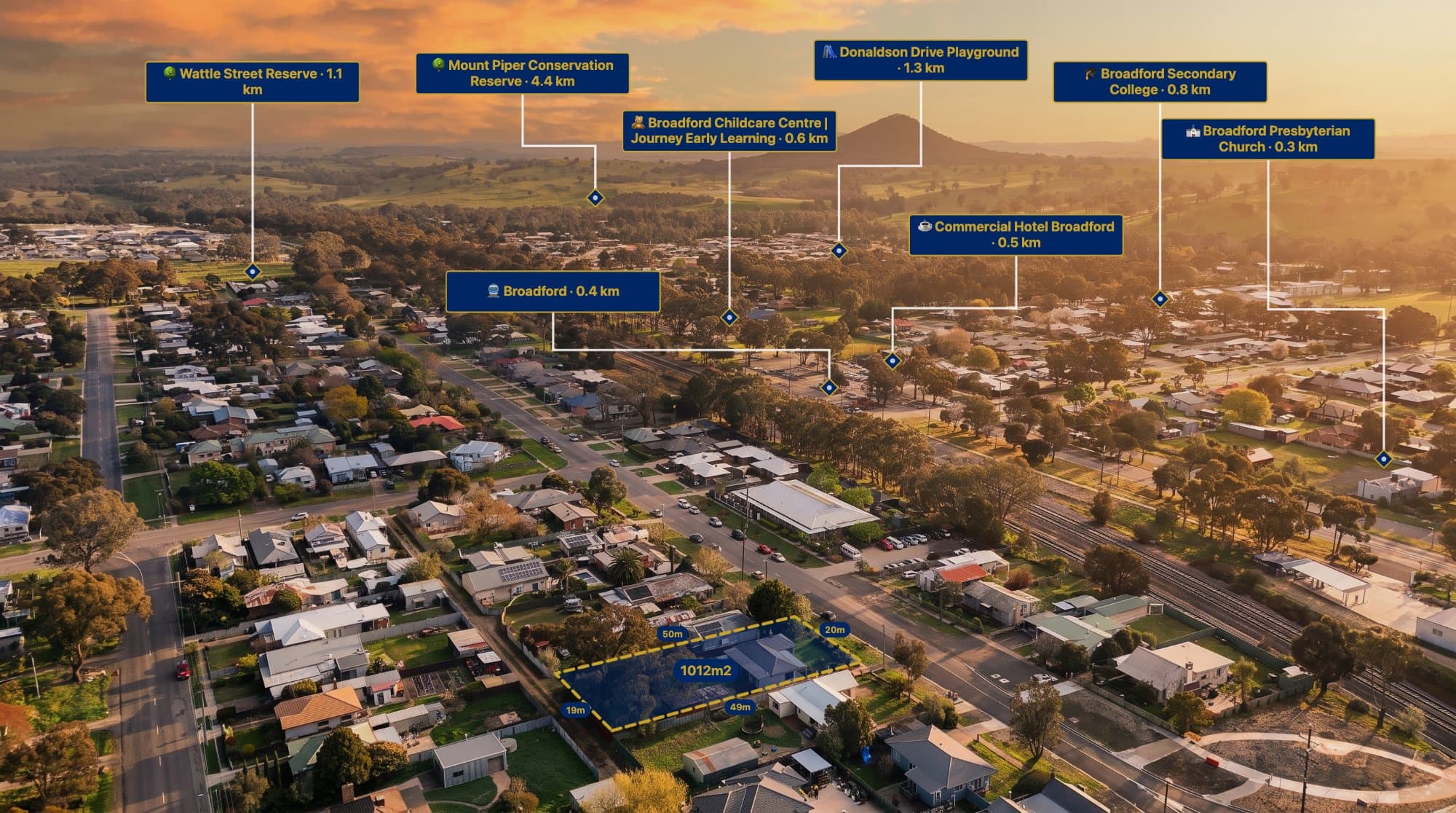
Adding location pins to aerial property photographs can make them much more informative.
A photographer might want to identify nearby schools, shopping centres, parks, roads and other important locations.
However, manually finding and positioning every pin can become repetitive, especially when preparing several property images.
Automatic location placement can help make this process easier.
What is automatic location pin placement?
Automatic location pin placement uses available location and camera information to estimate where nearby points of interest appear within an aerial photograph.
Rather than manually finding every location and placing every pin, a supported system can use available metadata to help position annotations.
The quality of the result depends on the image, metadata and available geographic information.
How does automatic pin placement work?
Several pieces of information can help estimate the position of a nearby location in an image.
1. GPS coordinates
GPS coordinates help identify the approximate location where the photograph was captured.
This provides a geographic starting point for finding nearby places.
2. Camera direction
Camera heading can help determine which direction the camera was facing when the photograph was taken.
This can help estimate whether a nearby point of interest is within the camera's field of view.
3. Camera and gimbal angle
Where available, camera orientation and gimbal information can help estimate how the image is framed.
This is useful because an aerial photograph may be looking directly down or towards the horizon.
4. Nearby points of interest
A nearby place search can identify locations around the photograph's GPS position.
Examples include:
-
Schools.
-
Parks.
-
Shopping centres.
-
Hospitals.
-
Sporting facilities.
-
Transport locations.
The system can then use the available location and camera information to estimate which places may be visible in the image.
How to automatically place location pins using AerialPin
AerialPin includes an Auto Place feature designed to help users add location pins to supported aerial photographs.
Here's how the workflow works:
Step 1: Upload your drone photograph
Start by uploading a compatible aerial photograph containing useful GPS and camera metadata.
Original photographs are generally the best starting point.
Step 2: Open Auto Place
Use AerialPin's Auto Place feature to begin the automatic location placement workflow.
Step 3: Choose the number of locations
Select how many nearby locations you want the system to consider placing.
The best number depends on the photograph and how much information you want to display.
Step 4: Generate the location pins
AerialPin uses available image and location information to help identify and position relevant nearby places.
Step 5: Review the results
Check the pins before exporting the image.
Automatic placement is an estimate, so some pins may need adjustment or removal depending on the photograph.
Step 6: Customise your annotations
Adjust the labels, pin styles, colours and positioning to suit the property marketing design.
What makes a good photograph for automatic pin placement?
For the best results, use a photograph with:
-
Original GPS metadata.
-
Supported camera information.
-
A clear view of the surrounding area.
-
Suitable altitude and camera orientation.
-
Relevant nearby points of interest.
Edited or compressed images may have lost important metadata.
Results can also vary depending on the drone model, capture settings and available location information.
Why automatic pin placement is useful for real estate photographers
Automatic placement can help reduce repetitive manual work when creating aerial property marketing images.
Instead of researching and manually positioning every location pin, photographers can use an automated workflow as a starting point.
This can be especially useful when producing multiple property images for agents.
Try AerialPin Auto Place
AerialPin's Auto Place feature helps turn compatible drone photographs into more informative aerial marketing images.
Combine automatically positioned location pins with property boundaries, nearby search, labels and measurements to create a finished visual.
Learn more about AerialPin Auto Place.
Frequently asked questions
Can location pins automatically appear on drone photographs?
Yes. Supported software can use GPS, camera direction and nearby place information to estimate where location pins should appear.
Does automatic pin placement work with every drone?
Not necessarily. Results depend on the drone, camera metadata, photograph and supported information.
Can I choose which locations appear?
AerialPin allows users to select the number of locations to place. You should review the results and adjust the annotations before publishing.
Why are my location pins appearing in the wrong place?
Possible causes include missing or inaccurate metadata, camera orientation, altitude, image perspective and limitations in the automatic placement process.
Can I manually adjust automatically placed pins?
Yes. Reviewing and adjusting annotations is important to make sure the final image communicates the correct information.