
How to Create Better Aerial Images for Real Estate Agents
Learn how drone photographers can create better aerial real estate images using composition, property boundaries, location pins and professional annotations.
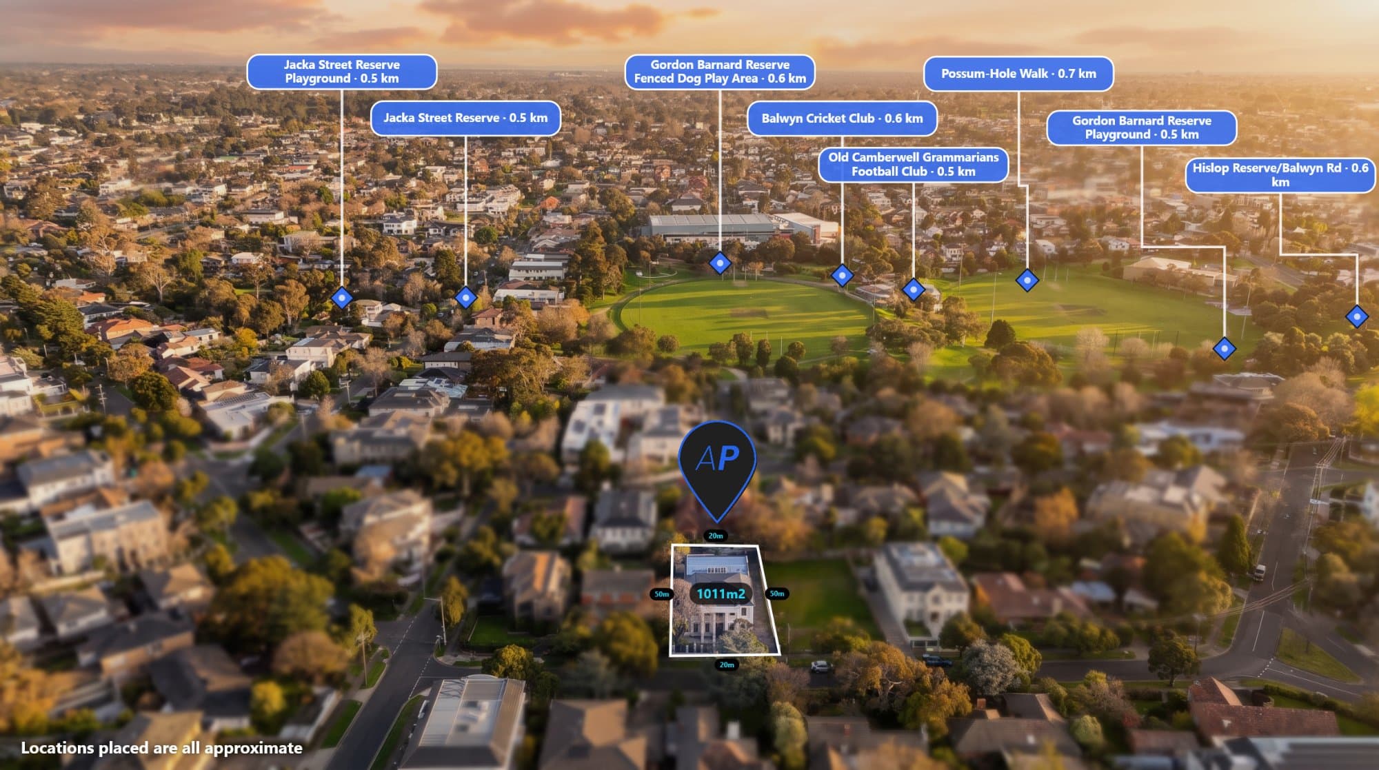
Aerial photography has become an important part of property marketing.
It gives potential buyers a different perspective of a home, showing the surrounding neighbourhood, land layout and nearby features.
But taking a good drone photograph is only the beginning.
Real estate photographers can create more valuable marketing images by combining strong aerial photography with clear annotations and location information.
Here are some ways to improve your aerial property images.
1. Capture the right angle
The angle of your photograph can make a significant difference.
A straight-down image is useful for showing land layout, property boundaries and surrounding structures.
An angled aerial image can provide more context and help viewers understand the property's position in the neighbourhood.
Consider capturing both styles where appropriate.
2. Focus on the property
The property should be easy to identify.
Avoid compositions where the main building or land area gets lost among surrounding streets and houses.
Give the subject enough space while still showing useful surrounding context.
3. Show property boundaries
For vacant land, acreage and larger properties, boundary annotations can help viewers understand which area is being marketed.
Use reliable boundary information and position the outline carefully.
A clear boundary overlay can make a large difference to the presentation.
4. Highlight nearby amenities
Real estate is about more than the building.
Buyers also consider location and surrounding facilities.
Consider highlighting:
-
Schools.
-
Parks.
-
Shopping centres.
-
Public transport.
-
Main roads.
-
Recreation facilities.
Use location pins and short labels to make these features easy to identify.
5. Add distance measurements
Where relevant, show how far important locations are from the property.
For example, you could highlight the distance to a nearby park or shopping centre.
Make sure you distinguish straight-line distance from actual travel distance.
6. Keep annotations consistent
A professional property marketing package should look consistent across all images.
Use a consistent approach to:
-
Colours.
-
Pin styles.
-
Fonts.
-
Boundary lines.
-
Labels.
-
Measurement graphics.
If you're working with multiple real estate agents, consider creating reusable styles that match their branding.
7. Avoid clutter
More annotations do not automatically make an image better.
Choose the information that matters most to the property.
Use clear labels, sensible spacing and colours that contrast with the image.
The objective is to make the photograph easier to understand, not overwhelm the viewer.
8. Use tools designed for aerial annotation
Traditional image editors can create attractive graphics, but manually placing every pin, label and boundary can take time.
AerialPin brings common aerial annotation tasks into one browser-based workflow.
You can upload your aerial photographs, add property boundaries, customise pins, search for nearby places and create distance annotations.
The platform also supports GPS-aware workflows for compatible drone imagery.
Explore AerialPin.
How photographers can offer more value to real estate agents
Adding aerial annotations can become an additional service within a real estate photography package.
For example, a photographer could offer:
-
Standard aerial photographs.
-
Annotated property boundary images.
-
Nearby amenity maps.
-
Distance measurement graphics.
-
Vacant land marketing visuals.
This gives agents more options when presenting properties and helps photographers differentiate their services.
Frequently asked questions
What makes a good real estate aerial photograph?
A strong composition, clear property focus, good lighting and useful surrounding context all contribute to a good aerial photograph.
Should real estate drone photos include property boundaries?
They can be particularly useful for vacant land, acreage and development sites, provided the boundary information is reliable.
How can photographers make aerial photos more useful?
Adding relevant labels, location pins, boundaries and measurements can help buyers understand the property and its surroundings.
Can I offer annotated aerial photos as an additional service?
Yes. Photographers can offer annotated imagery as an optional upgrade to standard aerial photography packages.