
How to Create Professional Real Estate Drone Photos Faster
Learn how real estate photographers can create professional drone marketing images faster using EXIF data, nearby locations, AI pin placement, styles and AI relighting.
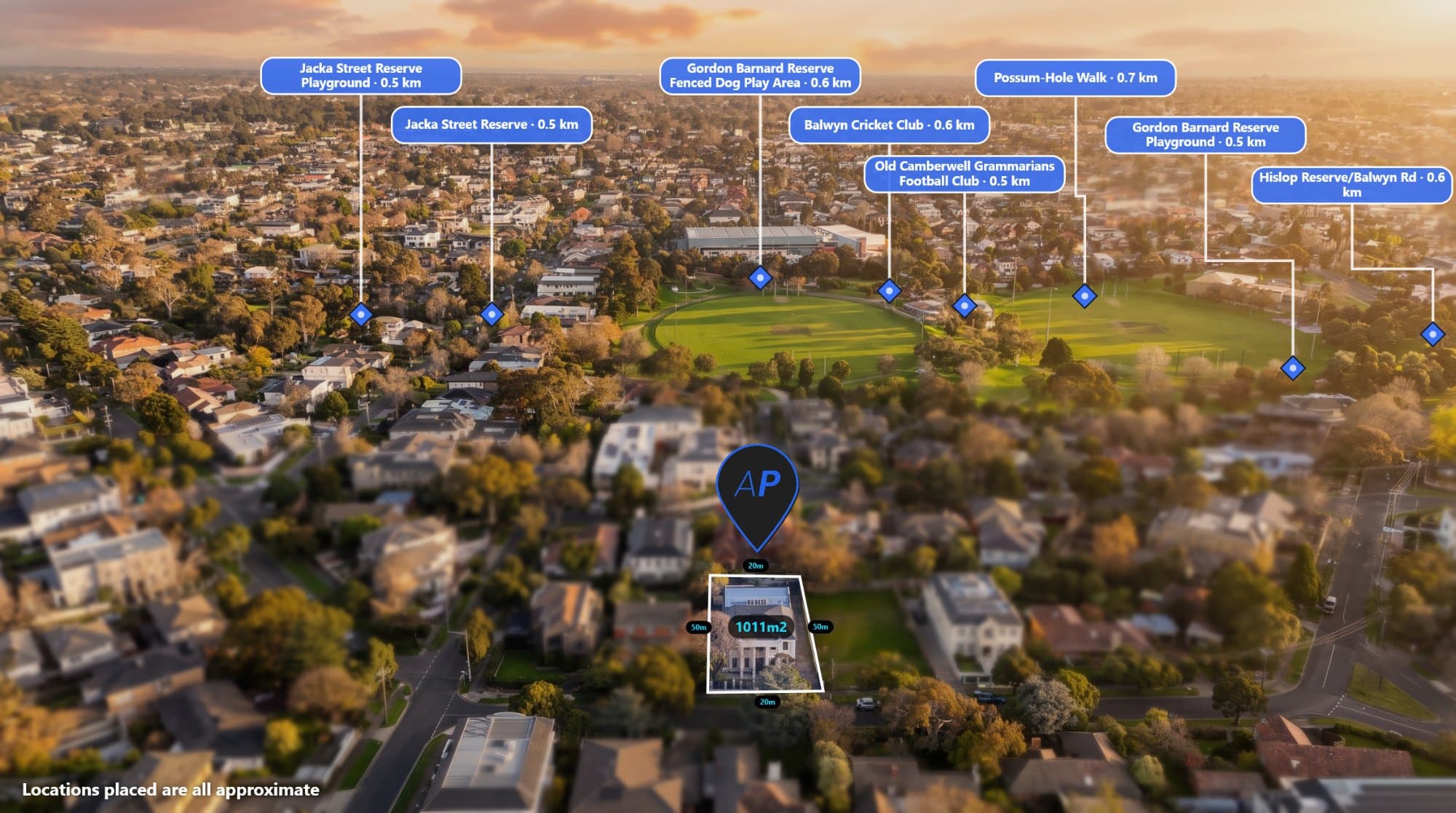
Real estate drone photography can be one of the most powerful marketing assets for a property.
An aerial photo can show the home, land, surrounding streets and nearby amenities in a single image. But for real estate photographers, creating the finished marketing image can involve much more than simply taking the photograph.
You may need to find nearby locations, add property boundaries, label points of interest, check your drone's GPS data, adjust the design and even create different versions of the image for your client.
Doing all of this manually can take time.
AerialPin is designed to make the process faster.
AerialPin brings together aerial image annotation, drone EXIF information, nearby location search, AI pin placement, image styling and AI relighting in one browser-based workflow.
What Makes a Good Real Estate Drone Photo?
A great aerial property image should do more than show the property.
It should help the potential buyer understand the property and its location.
Depending on the listing, you may want to show:
- The property boundary
- Nearby schools
- Parks
- Shopping centres
- Train stations
- Major roads
- Beaches
- Sporting facilities
- Other important landmarks
The challenge is adding all of this information without making the image look cluttered or spending hours manually editing it.
Start With the Original Drone Photo
Before adding anything to your image, it is useful to understand what information your drone has already captured.
Many original drone photographs contain EXIF metadata, including GPS coordinates, altitude, compass heading and gimbal information.
AerialPin's Drone EXIF & GPS Data tool lets you inspect this information directly from your drone photo.
You can check the GPS coordinates, altitude, camera heading, gimbal angle and camera settings before starting your annotation workflow.
This is particularly useful because the same information can help power other AerialPin features.
Find Nearby Locations Automatically
Once you know where the aerial photograph was captured, you can start adding useful locations around the property.
AerialPin's Nearby Search tool lets you search for nearby points of interest and choose which ones you want to display.
You can find locations such as:
- Schools
- Shopping centres
- Parks
- Train stations
- Supermarkets
- Cafes
- Medical facilities
- Sports grounds
- Local landmarks
You can also see the distance from the property, making it easier to communicate the property's location to potential buyers.
For example:
500m to local school
750m to shopping centre
1.2km to train station
These details can turn a basic aerial photograph into a much more informative marketing asset.
Automatically Place Pins With AI
Finding nearby places is useful, but manually positioning every label can still take time.
That's where AI Auto Place comes in.
AerialPin can use the GPS position, compass heading and gimbal angle stored in your drone photograph to work out which nearby locations the camera can actually see.
It then positions the relevant pins on the aerial image.
This is different from simply putting pins on a generic map.
The goal is to place locations based on the actual perspective of your drone photograph.
You can then review the result, move labels, remove locations or make any other adjustments before exporting.
Add Your Property Boundary
Nearby locations are useful, but the property itself should remain the focus of the image.
Adding a property boundary can make it immediately obvious which land is being marketed.
This can be especially useful for:
- Acreage
- Large residential blocks
- Development sites
- Vacant land
- Rural properties
- Commercial properties
You can combine the property boundary with nearby location labels to show both the property and its surroundings.
Make Your Drone Photos Match Your Brand
Professional real estate photographers often work with agencies that have specific branding requirements.
Your aerial annotations might need to use particular colours, fonts, pin designs and spacing.
Instead of rebuilding your design every time, you can use AerialPin Styles to create reusable annotation templates.
You can customise:
- Pin shape
- Pin colour
- Typography
- Label size
- Borders
- Leader lines
- Boundary styling
- Spacing
Once you have a style you like, you can save it and reuse it across future property images.
This helps your aerial photography look consistent from listing to listing.
Create Multiple Looks From One Drone Photo
Sometimes the weather or lighting isn't ideal when you capture the property.
You may have a great aerial composition, but the sky could be flat or overcast.
AerialPin's AI Relight tool can create different lighting looks from the original aerial photograph.
You can create options such as:
- Bright day
- Golden hour
- Twilight
- Clear sky
The tool is designed to change the sky and lighting while keeping the existing property, buildings, landscaping and other elements of the scene intact.
This can give photographers more options from a single drone flight.
Keep Your Original Drone Data
One important tip for real estate photographers is to keep the original drone file.
Metadata can sometimes disappear when an image is processed through editing software, messaging applications or other platforms.
If you need the GPS coordinates, altitude or camera orientation later, the original file is the safest place to start.
The AerialPin EXIF tool can help you check what information your drone photo contains.
This can also help identify why an image may not be suitable for automatic pin placement.
A Faster Real Estate Drone Photography Workflow
Instead of using multiple tools for every property, you can build a workflow around the information already contained in your drone photograph.
Step 1: Capture the property
Fly the drone and capture your aerial images as usual.
Step 2: Check the EXIF data
Use Drone EXIF & GPS Data to check that the image contains the information you need.
Step 3: Find nearby locations
Use Nearby Search to find schools, parks, shopping, transport and other points of interest.
Step 4: Automatically place the labels
Use AI Auto Place to position relevant locations based on the drone's camera perspective.
Step 5: Add the property boundary
Draw and customise the boundary directly on the aerial image.
Step 6: Apply your style
Use Drone Photo Styles to keep your annotations consistent with your branding.
Step 7: Create another look if needed
Use AI Relight if you want to create a different time-of-day or sky option.
Step 8: Export
Once everything looks right, export the finished aerial marketing image.
Why Automate Real Estate Drone Photo Editing?
The goal isn't to automate the creative side of photography.
You still need to capture the right composition, choose the right property angle and decide what information is worth showing.
The repetitive tasks are different.
Searching for locations.
Positioning labels.
Checking metadata.
Restyling annotations.
Creating additional versions.
These are the tasks that can consume time when you're working through multiple property listings.
Automation can help reduce that workload.
Turn One Drone Photo Into a Better Marketing Asset
A single drone photograph can contain much more information than what is visible at first glance.
The image can contain GPS coordinates and camera information.
That data can help identify the property's location.
The location can help find nearby amenities.
The camera direction can help determine which locations are actually visible.
Those locations can then become labels on the image.
The final result is an aerial photograph that communicates much more than the original image.
AerialPin for Real Estate Photographers
AerialPin is built around this workflow.
Instead of treating a drone photo as just another image file, it uses the information contained within the image to help create a more useful property marketing asset.
From checking drone EXIF data to finding nearby locations, automatically placing pins, creating consistent annotation styles and relighting aerial images, the goal is to make the aerial photography workflow faster.
If you're a real estate photographer who regularly creates aerial property marketing images, try AerialPin.
Capture the property once. Use the data in your drone photo. Create more useful marketing images.