
How to Label Drone Photos for Real Estate Marketing
Learn how to add locations, property boundaries and points of interest to drone photos for real estate marketing using drone GPS and EXIF data.
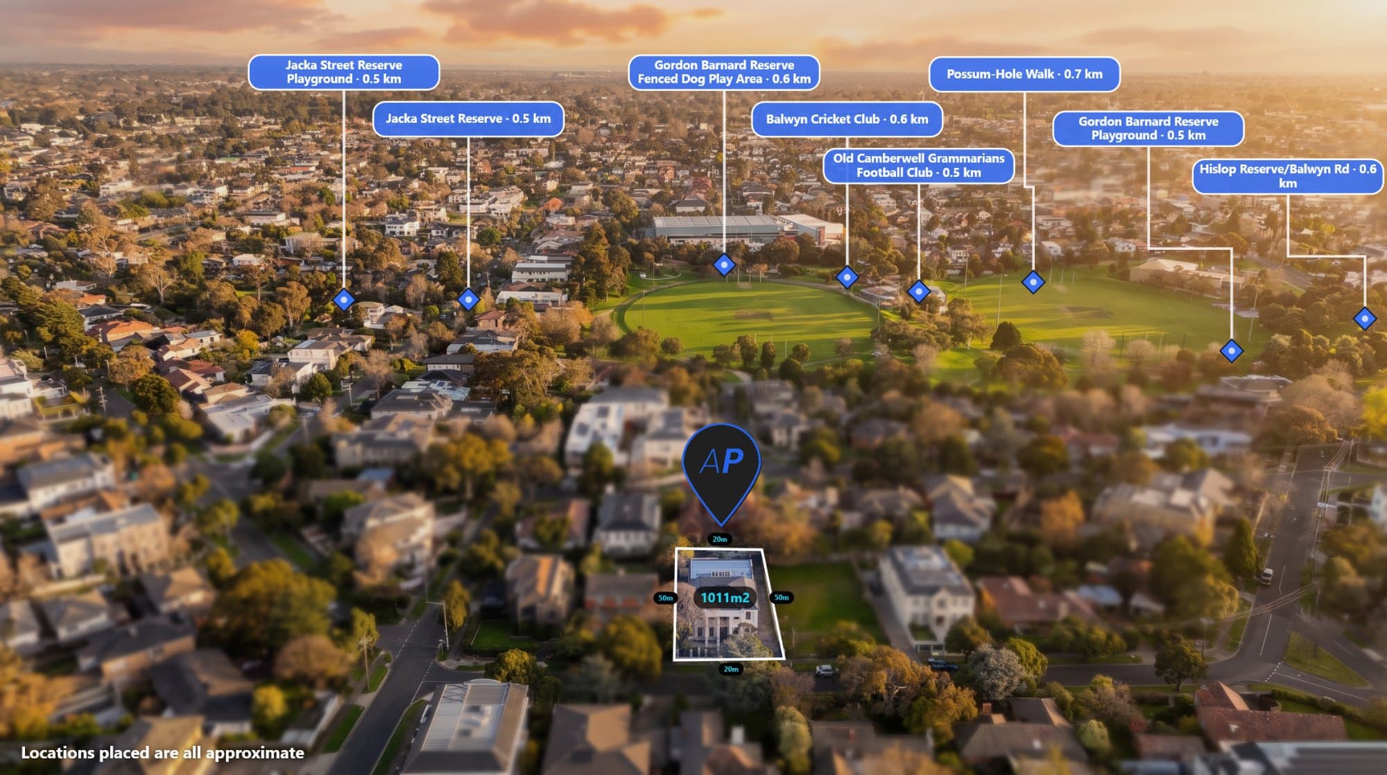
Real estate drone photography can do more than show a property from above.
With the right annotations, an aerial photo can show potential buyers exactly where the property is located and what is nearby.
You can highlight schools, parks, shopping centres, train stations, beaches, major roads and other important points of interest directly on the drone photo.
The challenge is finding and adding all of this information without spending a huge amount of time manually editing every image.
AerialPin makes it easier.
AerialPin is a tool built for real estate photographers, drone operators and property marketers who want to create professional annotated aerial images.
Why Add Locations to a Drone Photo?
Aerial photography gives buyers a different perspective of a property.
However, a standard drone photo doesn't always tell the full story.
A property might be:
- 500 metres from a local school
- 800 metres from a shopping centre
- Close to a train station
- Next to a park
- Minutes from the beach
- Conveniently located near major roads
Adding these locations directly to the aerial photo gives buyers more information without requiring them to open a map and search for themselves.
Instead of simply showing the property, you can show the property and its surrounding lifestyle.
How Do You Add Locations to a Drone Photo?
Traditionally, adding locations to an aerial photograph requires several steps.
You might need to:
- Find the property's location.
- Open a mapping application.
- Search for nearby points of interest.
- Work out which locations are visible from the drone's perspective.
- Take note of their distances.
- Open Photoshop.
- Add pins and labels.
- Position everything manually.
- Export the final image.
For one photograph, this isn't necessarily a problem.
For a real estate photographer working on multiple properties every week, it can become a repetitive task.
AerialPin is designed to simplify this process.
Use the GPS Data Inside Your Drone Photo
One of the most useful features of modern drone photography is something many people don't think about: EXIF metadata.
Your drone photograph can contain information about where and how the photograph was captured.
Depending on the drone and camera, the image may contain:
- GPS coordinates
- Altitude
- Camera heading
- Gimbal angle
- Camera information
- Date and time
This information can help software understand the position of the drone and the direction of the camera.
AerialPin can read supported drone image metadata and use this information when working with your aerial photograph.
Find Nearby Places Automatically
Once AerialPin knows where the photograph was taken, you can search for nearby points of interest.
You can find locations such as:
Schools
Highlight nearby primary and secondary schools.
Shopping
Show shopping centres, supermarkets and retail areas.
Parks
Highlight parks, reserves and recreational areas.
Transport
Show nearby train stations, tram stops and other public transport.
Roads
Highlight important roads and connections around the property.
Local Attractions
Add beaches, sporting facilities and other locations that may be important to buyers.
This makes the aerial image much more informative.
Automatically Place Locations on the Image
Finding nearby locations is only part of the process.
You also need to position them correctly on the photograph.
AerialPin's AI Auto Place feature is designed to help with this.
By using information from the drone image, including its location and camera orientation, AerialPin can determine which nearby places are relevant to the view and automatically position pins on the aerial photograph.
You can then review the result and make any adjustments before exporting.
Add Property Boundaries Too
Locations aren't the only thing you can add to a drone photo.
Property boundaries can make an aerial image significantly more useful for real estate marketing.
AerialPin allows you to create a boundary directly on your image.
This can be particularly useful for:
- Acreage properties
- Large blocks
- Development sites
- Vacant land
- Rural properties
- Commercial properties
A buyer can immediately see which section of the aerial photograph represents the property.
Create Professional Looking Labels
Adding information to a drone photo doesn't mean the image needs to look cluttered.
AerialPin lets you customise your annotations so you can create a consistent design across your property marketing images.
You can customise elements such as pins, labels, typography, colours and other visual settings.
You can also save styles for future projects.
This can be especially useful for professional real estate photographers who want their aerial images to have a consistent appearance.
AerialPin for Real Estate Photographers
If you're a real estate photographer, speed matters.
You may be photographing several properties in a single day, followed by hours of editing and delivery.
Spending additional time manually creating aerial annotations can make the workflow even longer.
AerialPin is designed to remove some of that repetitive work.
Instead of manually researching every nearby location and positioning every label from scratch, you can use the information already contained in the drone image to get started.
A Simple Drone Photography Workflow
A traditional workflow might look like this:
Fly the drone → edit the photograph → search Google Maps → find locations → create labels → open Photoshop → position everything → export
With AerialPin, the workflow can be much simpler:
Fly the drone → upload the image → find nearby locations → add boundaries → customise → export
The goal is to spend less time creating the graphic and more time focusing on your photography business.
What Makes a Good Real Estate Aerial Image?
A good annotated aerial photograph should provide useful information without overwhelming the viewer.
The most effective images usually focus on the locations that actually matter to a buyer.
For example, you might show:
- The property boundary
- The nearest school
- The closest shopping centre
- A nearby train station
- A major park
- An important road
You don't necessarily need to label everything.
The goal is to highlight the information that helps communicate the property's location.
Use Your Drone's Data to Save Time
Your drone photograph can contain valuable information before you even begin editing it.
GPS coordinates can tell you where the image was captured.
Altitude can provide information about the drone's position.
Compass heading can help determine which direction the camera was facing.
Gimbal information can help understand the camera's viewing angle.
When this information is combined with nearby location data, it becomes possible to create a much smarter workflow for aerial property marketing.
That's the idea behind AerialPin.
Turn Your Drone Photos Into Property Marketing Images
Real estate photographers already spend time capturing and editing great aerial photographs.
The next step is making those photographs useful for marketing.
Adding property boundaries, nearby locations and labels can turn a standard aerial photograph into an informative property marketing asset.
Instead of manually creating every annotation from scratch, AerialPin helps automate parts of the process using the information contained in your drone photograph.
Upload your drone photo. Find the locations. Add the information. Create a better property marketing image.