
How to Label Locations on Drone Photos
Learn how to label locations on drone photos with clear pins and text annotations. Whether you're highlighting schools, parks, shopping centres, roads or other points of interest, AerialPin makes it easier to add useful location information directly to aerial photography.
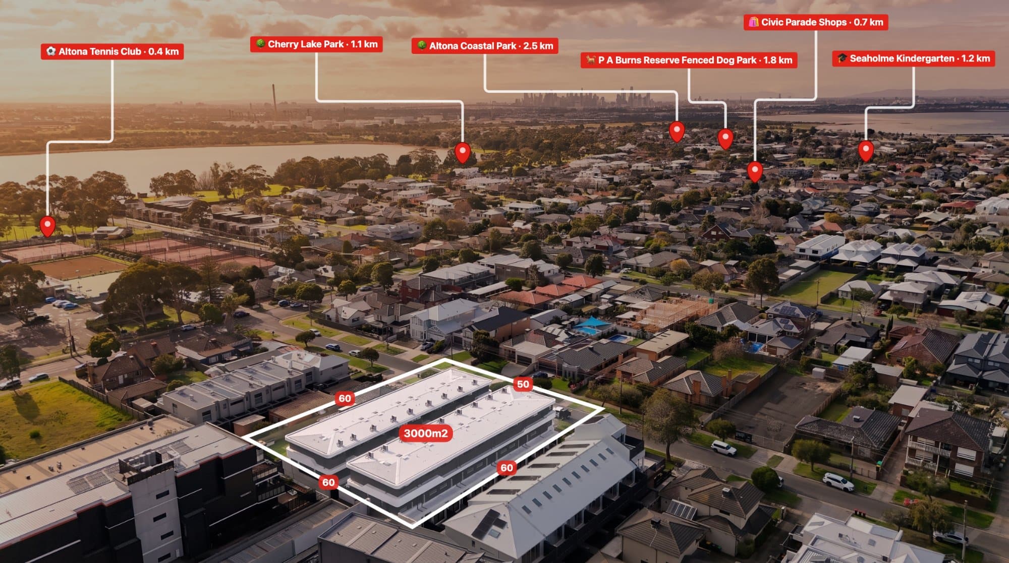
Drone photography gives you a view of a property and its surroundings that you simply can't get from the ground.
But when you're using aerial images for real estate marketing, land sales or property development, the people viewing the photo may not know exactly what they're looking at.
A school might just look like a building. A park might just look like a patch of green. A major road might not be obvious from above.
Adding location labels to drone photos makes those features easier to understand.
With a tool such as AerialPin, you can add location pins and labels directly to your aerial photography.
What Are Location Labels?
Location labels are text or visual markers that identify specific places within an aerial photograph.
For example, a property marketing image could label:
- Local schools
- Shopping centres
- Parks
- Train stations
- Roads
- Cafes
- Sporting facilities
- Beaches
- Other points of interest
Instead of leaving the viewer to guess what they're looking at, the label provides immediate context.
Why Label Locations on Drone Photos?
Aerial photography is excellent for showing relationships between properties and their surroundings.
However, the viewer may not recognise every feature in the image.
A location label can make the image more informative.
For example, instead of simply showing a property surrounded by streets, you could identify:
Property
Primary School
Shopping Centre
Train Station
Community Park
This is particularly useful for real estate marketing because buyers often want to understand what's located around a property.
How to Label a Drone Photo
1. Start With Your Original Drone Image
Begin with a high-quality aerial photograph.
If your drone stores GPS information in the image's EXIF metadata, keep the original file available.
The GPS coordinates can help determine where the photograph was taken.
2. Upload Your Photo
Upload the aerial photograph into your annotation software.
AerialPin is a browser-based tool designed for annotating drone and aerial photographs.
3. Find Nearby Locations
Once your image is positioned correctly, you can search for nearby points of interest.
AerialPin Nearby Search lets you find locations around the property and add them to the image.
This can be useful when you want to identify amenities that are visible in the aerial photograph.
4. Add the Location Pin
Select the location you want to show and add its pin to the aerial photograph.
The pin provides a visual reference that connects the label to the actual location.
5. Add a Clear Label
A label can provide the name or type of location.
For example:
Greenvale Shopping Centre
Local Primary School
Community Park
Train Station
Keep labels short and easy to read.
Use AI to Automatically Place Locations
If you're creating lots of annotated drone photographs, manually adding every location can take time.
AerialPin AI Auto Place can help automate the process of identifying and placing relevant locations.
It uses available geographic and camera information to help determine suitable nearby locations for the image.
This can be useful for photographers who regularly create annotated property images.
Label Property Boundaries
Location labels don't have to be limited to nearby amenities.
You can also use annotations to explain what's happening within the property itself.
For example, a development site could be labelled with:
Stage 1
Future Homes
Development Site
Access Road
Open Space
AerialPin also lets you add property boundary overlays, making it easier to distinguish the site from surrounding land.
Add Distance Measurements
Another useful annotation is a distance measurement.
For example:
500 m to School
850 m to Shopping
1.2 km to Train Station
Combining labels with measurements can provide a quick overview of the surrounding area.
Use Labels for Real Estate Marketing
Real estate photographers can use location labels to create additional marketing images for agents.
A typical aerial property image might contain several carefully selected labels showing the most relevant nearby locations.
This can be useful for:
- Property listings
- Social media
- Agent presentations
- Property brochures
- Development marketing
- Land sales
The key is to keep the image clean.
Too many labels can make an aerial photograph difficult to read.
Use Labels for Property Developers
Developers can use aerial labels to explain a project and its surroundings.
For example, an annotated development aerial might identify:
- Development boundary
- Proposed roads
- Existing roads
- Nearby schools
- Parks
- Shopping
- Public transport
- Surrounding estates
This gives viewers a visual understanding of the project's location.
How Many Locations Should You Label?
There is no fixed number of labels that works for every aerial photograph.
The best approach is to focus on the locations that are actually relevant.
For a residential property, three to six important locations might be enough.
For a large development site, you may need more.
Think about what someone looking at the photograph would actually want to know.
Keep Your Labels Easy to Read
Good aerial annotations should improve the photograph rather than overwhelm it.
A few simple principles can help:
Keep text short
Long descriptions can quickly clutter an aerial image.
Use consistent placement
Try to keep your labels aligned and visually organised.
Prioritise important locations
You don't need to label every business or building in the surrounding area.
Don't cover the property
The main subject of the photograph should remain visible.
Recovering Location Information From Drone Photos
Sometimes GPS information can disappear when a drone photograph is edited or exported.
This can make location-based workflows more difficult.
If you still have the original drone photograph, you can use AerialPin's EXIF tools to work with the original metadata.
Keeping the original files is therefore useful whenever possible.
Label 360 Aerial Images
Location annotations aren't limited to standard aerial photographs.
AerialPin also supports 360 panorama workflows.
You can stitch multiple drone photographs into a panorama and then use the 360 viewer to inspect and annotate the result.
The 360 panorama functionality is currently in beta.
This can be useful for larger properties and development sites where a single aerial photograph doesn't provide enough visual information.
Create More Useful Drone Photography
A drone photograph doesn't have to be just a photograph.
With the right annotations, it can also communicate information about the property and its surroundings.
Location pins, labels, boundaries and measurements can make aerial images easier to understand and more useful for property marketing.
AerialPin brings these tools together in a browser-based workflow designed for drone operators, real estate photographers, agents and property developers.