
How to Make Drone Photos Look Professional for Real Estate
Learn how to make drone photos look professional with real estate editing tips, camera techniques and AI-powered tools like AerialPin for better aerial marketing.
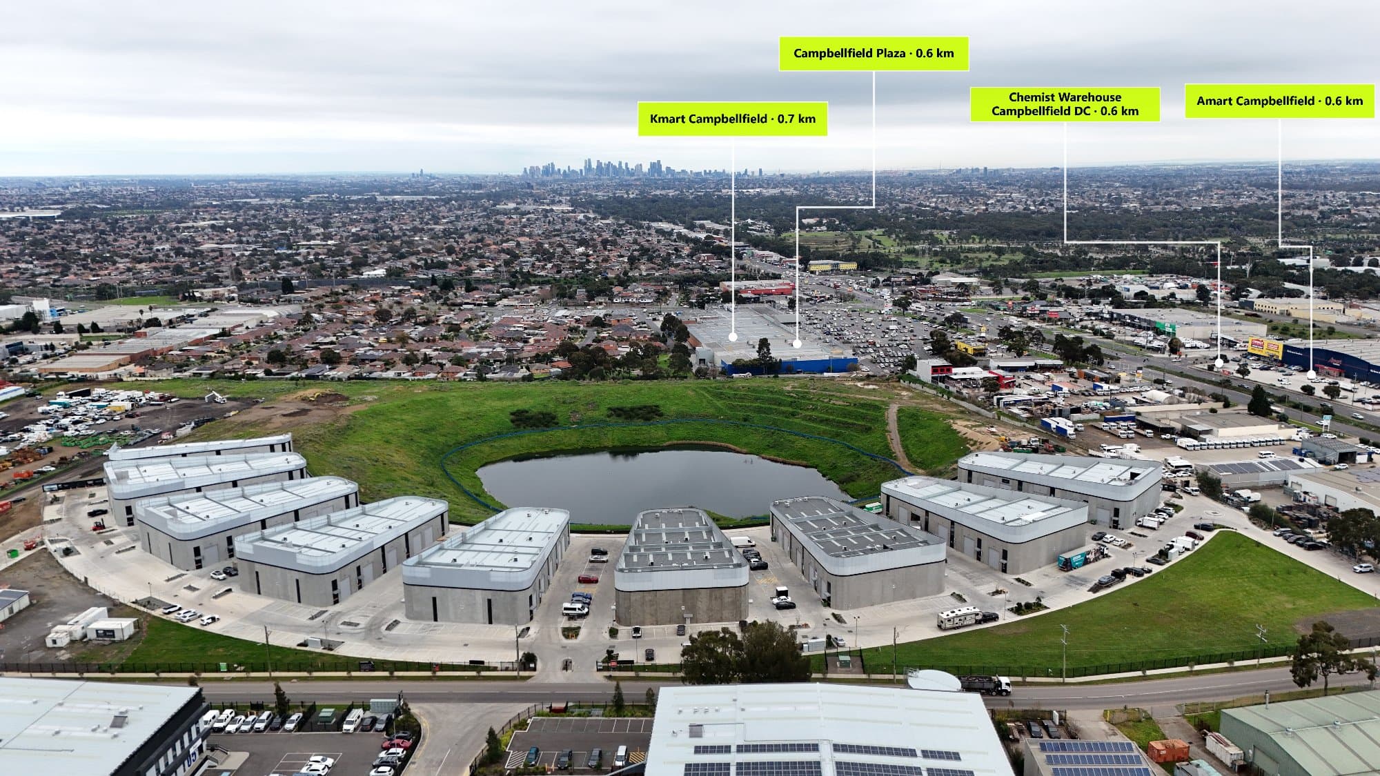
Learn how professional drone photographers create high-quality aerial images for real estate marketing. Discover camera tips, editing techniques and how AerialPin helps turn drone photos into powerful property marketing assets.
Drone photography has become one of the most important tools in modern real estate marketing. A well-captured aerial image can instantly show a property's size, location and surrounding lifestyle benefits.
However, not every drone photo automatically looks professional.
Creating premium aerial images requires the right combination of flight technique, camera settings, composition, editing and presentation.
For real estate professionals, the goal is not just to capture a property from above. The goal is to create an image that helps buyers understand the full value of the property and its location.
Tools like AerialPin help photographers take aerial marketing further by adding accurate Point of Interest labels and location information directly onto drone images.
1. Plan Your Drone Shots Before Flying
Professional drone photography starts with preparation.
Before taking off, consider:
- The property's best angles
- The direction of sunlight
- Important surrounding features
- The story you want the image to communicate
Random aerial photos often look less impressive because they lack purpose.
A strong real estate drone image should answer questions buyers naturally have:
- Where is the property located?
- What surrounds the home?
- What lifestyle benefits are nearby?
2. Capture Images During the Best Lighting
Lighting is one of the biggest differences between an average drone photo and a professional one.
The best conditions for real estate drone photography are usually:
Golden Hour
Early morning and late afternoon provide softer lighting, warmer colours and more depth.
Overcast Weather
Cloudy conditions create balanced lighting and reduce harsh shadows.
Avoid Harsh Sunlight
Midday sunlight can create strong contrast and make properties appear flat.
Professional photographers understand that lighting can completely change the feeling of an image.
3. Shoot in RAW Format
If your drone supports RAW photography, use it.
RAW files contain more image information compared to compressed JPEG files.
This gives photographers more flexibility when adjusting:
- Exposure
- Highlights
- Shadows
- Colours
- Contrast
RAW editing is especially useful when recovering details from bright skies or darker areas around a property.
4. Use Better Composition Techniques
A professional drone image still follows traditional photography principles.
Important composition techniques include:
Leading Lines
Use roads, paths, fences and landscaping to guide the viewer's eye towards the property.
Balance
Avoid placing the property awkwardly within the frame.
Symmetry
Symmetrical homes, driveways and landscaping can create visually appealing images.
Scale
Include surrounding elements to show the property's size and location.
5. Show More Than the Roof
One common mistake in drone photography is focusing only on the building.
Buyers want to understand the entire location.
A great aerial image can show:
- The property
- The neighbourhood
- Nearby amenities
- Surrounding landscape
The location is often one of the biggest selling points.
6. Edit Drone Photos Professionally
Editing is where good drone photos become great marketing images.
Professional editing can include:
- Correcting exposure
- Improving colours
- Enhancing contrast
- Adjusting highlights
- Recovering shadows
- Creating a consistent style
However, editing should enhance the image, not make it unrealistic.
Over-editing can make properties look artificial and reduce buyer trust.
7. Add Location Information With POI Overlays
A professional aerial image can become even more valuable when it includes location information.
Point of Interest overlays can highlight:
- Schools
- Parks
- Shopping centres
- Train stations
- Beaches
- Restaurants
- Local attractions
Instead of expecting buyers to research the area, the image instantly communicates the property's surroundings.
With AerialPin, photographers can automatically add location pins to drone images using AI-powered technology.
8. Keep Your Branding Consistent
Professional photographers should create a consistent visual style.
This includes:
- Similar colours
- Matching fonts
- Consistent editing
- Professional layouts
- Clean annotations
Consistency helps clients recognise your work and creates a premium experience.
9. Export Images Correctly
The final export matters.
Different platforms require different formats.
For real estate marketing:
Website Listings
Use high-quality JPEG files that maintain image clarity while keeping file sizes reasonable.
Social Media
Optimise images for platform dimensions while maintaining quality.
Print Marketing
Export high-resolution files suitable for brochures and property campaigns.
Common Drone Photography Mistakes
Poor Camera Positioning
A bad angle can make a property look smaller or less appealing.
Flying Too High
Higher altitude does not always create a better image.
The property should remain the focus.
Ignoring the Surroundings
Aerial photography should communicate the location, not just the building.
Adding Too Much Information
Too many labels or graphics can make an image confusing.
Professional design is about balance.
How AerialPin Helps Create Better Drone Marketing Images
AerialPin helps photographers add another layer of information to their aerial images.
Instead of manually searching maps and placing every location marker, photographers can:
- Upload drone images
- Automatically detect nearby locations
- Add Point of Interest labels
- Customise pin styles
- Export professional marketing images
This allows photographers to provide more value to real estate agents and property clients.
Who Benefits From Professional Drone Images?
Real Estate Photographers
Create higher-value packages and stand out from competitors.
Real Estate Agents
Provide buyers with more information and better marketing material.
Builders
Showcase projects, developments and surrounding infrastructure.
Property Developers
Highlight location advantages to potential buyers.
The Future of Real Estate Drone Photography
Drone photography is becoming more advanced every year.
The future is not only about higher-resolution cameras. It is about smarter images that communicate more information.
AI-powered tools are helping photographers automate repetitive tasks and create better marketing content faster.
With AerialPin, drone photographers can combine stunning aerial photography with intelligent location information.
Final Thoughts
Professional drone photography is about more than flying a drone and capturing an image.
The best aerial photos combine planning, composition, editing and useful information.
By improving your shooting techniques and using tools like AerialPin, you can create drone images that do more than look impressive. They can help buyers understand a property's location, lifestyle and value.
AerialPin helps real estate photographers transform ordinary drone photos into professional marketing assets with accurate location pins and Point of Interest overlays.