
How to Overlay Property Lines on Drone Photos
Adding property lines to drone photos is a simple way to make aerial real estate images more useful. Learn how to create clean property overlays, highlight the right block and use AerialPin to speed up the process.
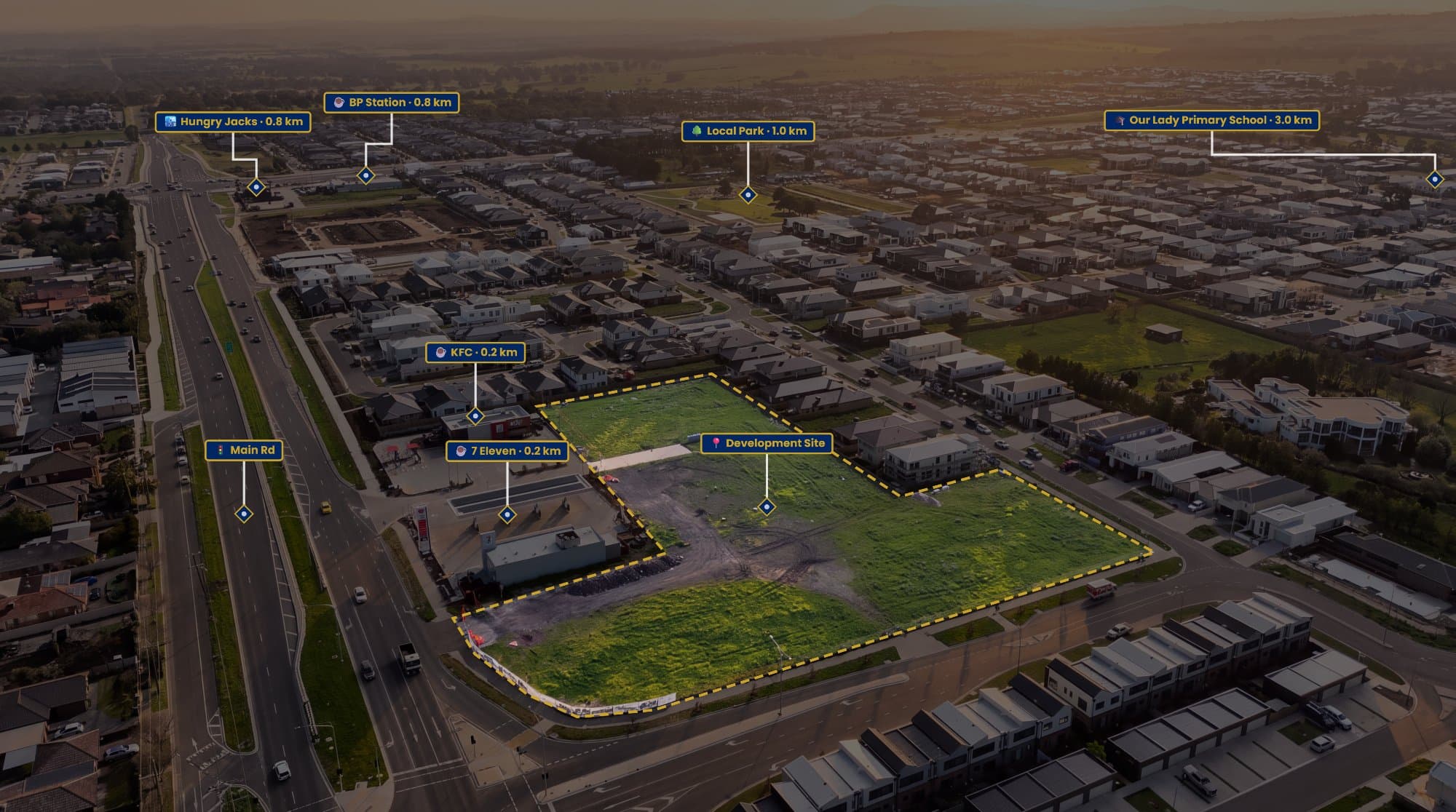
A drone photo can show an entire property in a way that a normal ground-level photo can't.
The problem is that the boundaries aren't always obvious.
A fence might be hidden by trees. A large backyard might blend into the neighbouring property. On acreage, it can be almost impossible to tell where one block finishes and another begins.
Adding a property line overlay gives the viewer a quick visual reference.
What Is a Property Line Overlay?
A property line overlay is simply a boundary drawn over an aerial photograph to show the approximate shape of the property.
The line usually follows the property's parcel boundary and can be combined with a transparent fill or spotlight effect to make the block stand out.
It works particularly well for:
- Acreage and rural properties
- Large residential blocks
- Vacant land
- Development sites
- Properties with unclear boundaries
- Properties with large backyards
The goal isn't to turn the photo into a map. It's to make the photograph easier to understand.
Where Do You Get the Property Boundary?
Before drawing anything, you need a reliable source for the boundary.
Depending on where you're located, this could be cadastral data, a property map, a title plan or a survey supplied by the owner.
In Australia, the available property information varies between states and territories, so it's worth using an appropriate local source rather than relying on what appears to be a fence line in the photograph.
This is important because the visible edge of a property isn't always the legal boundary.
The Photoshop Method
The simplest approach is to use Photoshop or another image editor.
Open your drone photo, create a new layer and use the Pen Tool or Polygon Tool to trace the property.
You can then adjust the colour, thickness and opacity of the line.
Adding a transparent fill inside the boundary can also help separate the property from the surrounding land.
The problem is that you're doing everything manually.
For one property, that's fine.
For ten or twenty properties, it becomes a repetitive part of the editing process.
Using AerialPin
AerialPin is built specifically around aerial property photography, so property boundaries can be created directly over your drone image.
Upload the photo, mark the points around the property and customise the appearance of the boundary.
You can also add a property label, measurements and other annotations without having to build the entire graphic from scratch in Photoshop.
This is particularly useful when you're producing aerial images for multiple real estate listings and want them to have the same look.
What Makes a Good Property Overlay?
You don't need a complicated design.
In most cases, a clean line and a subtle fill are enough.
The boundary should be easy to see against grass, roads, roofs and trees, but it shouldn't distract from the property itself.
A good overlay usually has:
A clear boundary
The viewer should immediately understand which block is being highlighted.
Consistent styling
Use the same line weight, colour and label style across your listing images.
Minimal clutter
Only add information that actually helps the viewer understand the property.
You Can Add More Than Property Lines
Once you've marked the property, you can use the aerial image to communicate more information.
For example, you could highlight a nearby park, school, shopping centre or train station.
AerialPin's AI Auto Place can help identify nearby points of interest from compatible drone imagery and position them within the photograph based on the drone's location and orientation.
That means your finished image can show the property and its surrounding location without needing a separate map.
What About Angled Drone Photos?
Straight-down drone photos are generally easier to align with property boundaries because there is less perspective distortion.
But real estate photographers often prefer angled aerial images because they show the house and land in a more visually appealing way.
That's where manually matching a flat property map to an angled photograph becomes more difficult.
Rather than simply copying a boundary from a map, use visible landmarks such as roads, driveways, buildings and fence corners to help position the outline.
The more reference points you have, the easier it is to create a convincing marketing overlay.
Don't Present It as a Survey
There's an important distinction between a property boundary visualisation and a legal survey.
A marketing overlay should not be presented as proof of the exact legal boundary.
Property datasets can contain inaccuracies, and the GPS information from a standard consumer drone isn't designed for survey-level boundary determination.
If exact legal boundaries are required, use appropriate survey information and a qualified land surveyor.
For marketing purposes, a clearly labelled approximate boundary can still be extremely useful.
Turn a Drone Photo Into a Better Marketing Asset
Aerial photography already gives buyers a different perspective of a property.
Adding a boundary makes that perspective easier to understand.
Add a few carefully chosen points of interest and you can show the property, the land and the surrounding area in one image.
That's ultimately what makes property overlays valuable. They're not there just to make the drone photo look different. They're there to give the viewer more information without making them open another map.
If you're regularly creating aerial real estate images, AerialPin can make the process much faster by bringing property boundaries, labels, measurements and nearby points of interest into one workflow.
Try AerialPin and start creating more informative aerial property images.