
Real Estate Photography: How Professional Property Photos Help Homes Sell
Learn how professional real estate photography, drone photography, floor plans, property boundaries and location annotations can improve your property marketing.
When it comes to selling a property, photography is one of the first things potential buyers notice. Before booking an inspection, making an enquiry or speaking with an agent, buyers often form their first impression from the property images they see online.
Professional real estate photography helps present a property accurately, attractively and consistently across property portals, agency websites and social media. From interior photography and architectural photography to drone imagery, floor plans and aerial property annotations, there are now more tools available to real estate professionals than ever before.
Why Real Estate Photography Matters
Property photography is more than simply taking pictures of a house. The goal is to communicate the layout, features, lifestyle and location of a property.
A professional real estate photographer considers composition, lighting, camera position, lens selection and editing to create images that showcase the property at its best.
High-quality images can be used across platforms such as realestate.com.au, Domain and an agency's own website.
For real estate agents, this means photography becomes an important part of the overall property marketing strategy.
Interior Real Estate Photography
Interior photography should make rooms feel spacious, bright and inviting while still representing the property realistically.
Common areas photographed include:
- Kitchens
- Living rooms
- Bedrooms
- Bathrooms
- Outdoor entertaining areas
- Garages
- Home offices
- Gardens and landscaping
Wide-angle lenses are commonly used to show more of a room, while careful camera positioning helps maintain natural-looking proportions.
Preparation is also important. Decluttering rooms, opening curtains, turning on appropriate lights and removing distracting objects can make a significant difference to the final images.
Exterior Property Photography
Exterior images are often among the first photographs a potential buyer sees.
A strong exterior photograph can communicate the architectural style, landscaping, frontage and overall presentation of the property.
Photographers may capture the property from different angles to show:
- Front facade
- Driveway and garage
- Backyard
- Pool
- Landscaping
- Outdoor entertaining areas
- Views from the property
Weather and time of day can also dramatically affect the appearance of an exterior photograph.
Drone Photography for Real Estate
Drone photography has become an increasingly useful part of property marketing, particularly for larger properties, acreage, coastal homes and properties with significant outdoor features.
Aerial imagery can show buyers information that traditional ground-level photography cannot.
For example, a drone photograph can demonstrate:
- Property size and surrounding land
- Swimming pools
- Gardens
- Nearby parks
- Water frontage
- Rural acreage
- Building orientation
- Driveways and access
- Surrounding neighbourhoods
Drone photography can also be useful for helping buyers understand how a property sits within its surrounding environment.
Photographers operating drones in Australia should follow the relevant rules and requirements from the Civil Aviation Safety Authority (CASA).
Adding Property Boundaries to Aerial Images
One of the challenges with aerial real estate photography is communicating exactly what land belongs to the property.
A beautiful drone image may show the house, neighbouring properties and surrounding streets, but it isn't always immediately obvious where the property's boundaries are.
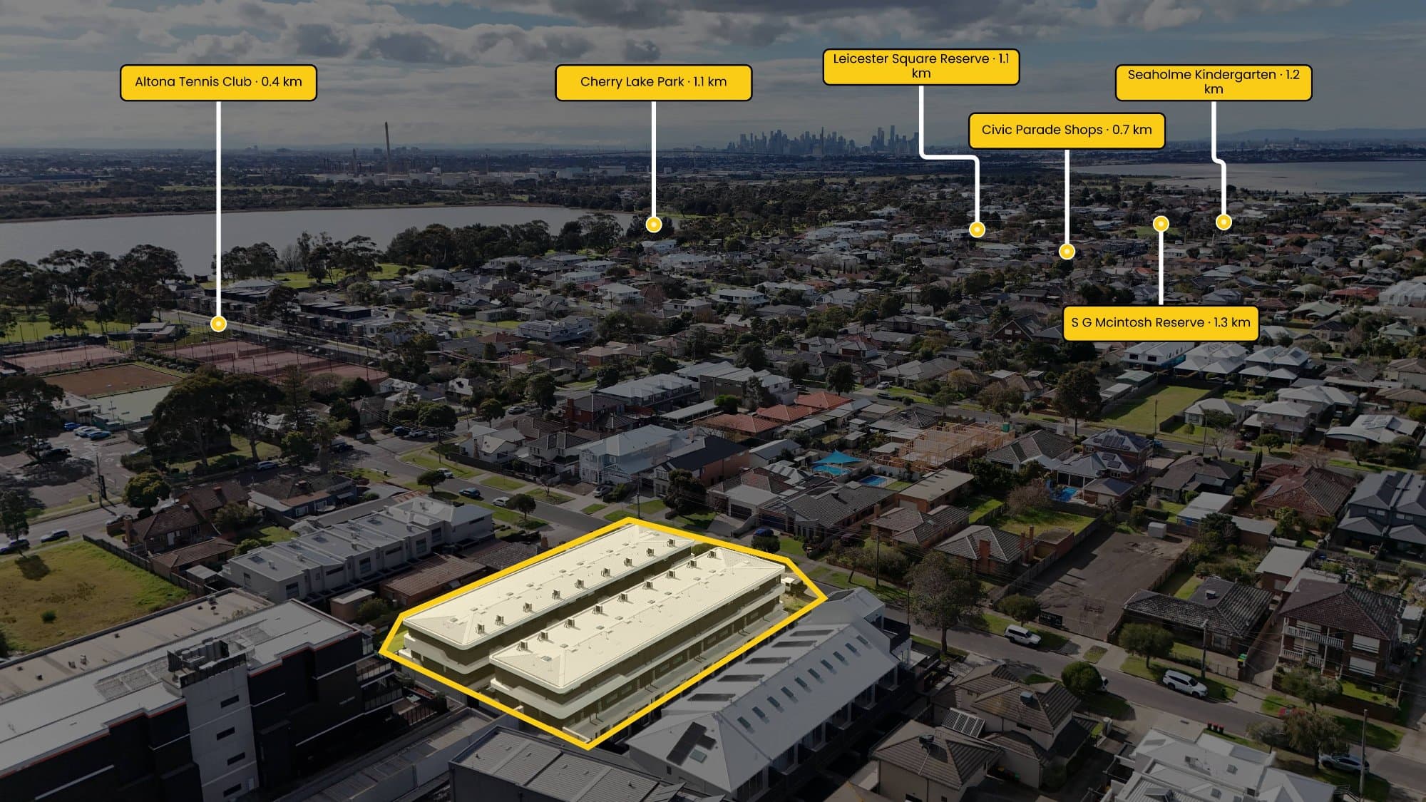
Adding a property boundary overlay can make an aerial image easier to understand.
For example:
Drone photograph → Property boundary → Labels → Points of interest → Distance measurements
This can be particularly useful for:
- Acreage properties
- Development sites
- Large residential blocks
- Vacant land
- Properties with unusual boundaries
- Properties near parks or waterways
The important thing is to make it clear that an annotation is a marketing visualisation and not a legal survey unless it is based on appropriate authoritative survey information.
Annotating Drone Photos for Real Estate Marketing
Real estate photographers sometimes need to add additional information to aerial photographs before delivering them to an agent.
This might include:
- Property boundaries
- Street names
- Parks
- Schools
- Shopping centres
- Train stations
- Distance markers
- Direction indicators
- Points of interest
Traditionally, photographers may use image-editing software such as Adobe Photoshop to manually create these graphics.
For photographers processing multiple properties, repeatedly drawing boundaries, adding labels and positioning markers can become a time-consuming part of the workflow.
This is one of the problems AerialPin is designed to solve.
A Faster Workflow for Aerial Property Images
AerialPin is designed specifically around the workflow of real estate photographers working with aerial property imagery.
Instead of treating an aerial photograph like a normal graphic-design project, AerialPin focuses on the information that property photographers commonly need to add to drone images.
A typical workflow can look like:
- Upload an aerial property photograph.
- Use the property's location information when available.
- Add or define the property boundary.
- Add points of interest and labels.
- Adjust the appearance of the annotations.
- Position markers on the aerial image.
- Export the finished image.
This can reduce the need to repeatedly open a complex image-editing application just to create a simple property-marketing graphic.
Real Estate Photography and Points of Interest
Points of interest can help communicate the lifestyle surrounding a property.
Depending on the property and the purpose of the image, photographers and agents may highlight locations such as:
- Schools
- Shopping centres
- Train stations
- Parks
- Beaches
- Sporting facilities
- Cafes
- Main roads
- Hospitals
For example, an aerial image might show a property with nearby parkland and a train station marked on the image. Rather than simply telling buyers where these locations are, the image provides a visual reference.
This can be particularly effective for properties where location is a major selling point.
Property Photography Beyond the Hero Image
A modern real estate marketing campaign often requires more than a set of property photographs.
A complete photography package might include:
Interior photography
Showcase the rooms, finishes and overall presentation.
Exterior photography
Show the facade, landscaping and outdoor areas.
Twilight photography
Create a more atmospheric presentation of the property at dusk.
Drone photography
Show the property from above and provide geographical context.
Floor plans
Help buyers understand the layout and relationship between rooms.
Aerial annotations
Communicate boundaries, locations and nearby points of interest.
Together, these assets can create a much more complete representation of a property.
Real Estate Photography for Agents
For real estate agents, the objective isn't simply to have attractive photographs. The content needs to work across the entire marketing campaign.
Property images can appear on:
- realestate.com.au
- Domain
- Agency websites
- TikTok
- YouTube
- Digital advertisements
- Property brochures
- Email campaigns
This means photographers need to deliver assets that are visually strong and practical for different marketing channels.
How Technology Is Changing Property Photography
Real estate photography is becoming increasingly connected with software.
Photographers can now use tools for image editing, HDR processing, virtual staging, floor-plan creation, drone mapping, image delivery and property marketing.
The next step is reducing repetitive work.
If a photographer is manually performing the same annotation process for every property, there is an opportunity to automate parts of that workflow.
That's the idea behind AerialPin: spend less time manually annotating aerial images and more time photographing properties.
Real Estate Photography Workflow Checklist
Before delivering an aerial property image, photographers can check:
- Property boundary is positioned correctly
- Labels are readable
- Points of interest are relevant
- Markers don't cover important parts of the property
- Distance measurements are clear
- Image resolution is appropriate
- Annotations are visually consistent
- Exported image has been checked before delivery
A consistent workflow helps photographers maintain professional-looking deliverables across multiple properties and agencies.
Final Thoughts
Professional real estate photography has evolved far beyond taking a few photographs of a house.
Today, photographers can combine interior photography, exterior photography, drone imagery, floor plans, location information and aerial annotations to create a much more complete picture of a property.
For photographers who regularly produce aerial property images, the biggest opportunity may be reducing the repetitive work involved in preparing those images for clients.
AerialPin is built to make aerial real estate annotation faster, simpler and easier to repeat across property photography workflows.
Whether you're photographing a suburban home, acreage property, development site or investment property, better aerial presentation can help communicate information that a standard property photograph simply can't show.
Real estate photography isn't just about taking the photo. It's about making the property easier to understand.