
What Is a Point of Interest (POI) Overlay in Real Estate Photography?
Learn what a Point of Interest (POI) overlay is and how it improves real estate photography. Discover how AerialPin uses AI to automatically add location labels to aerial images.
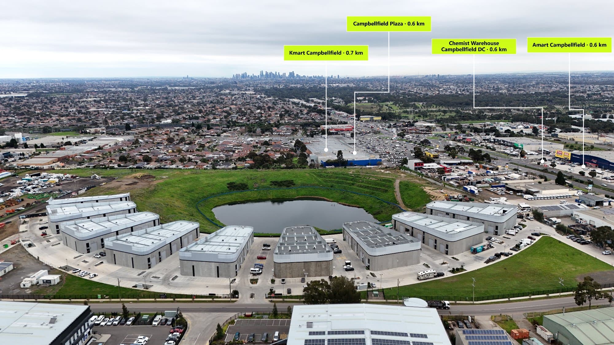
Learn what a Point of Interest (POI) overlay is, how it improves real estate photography, and how AerialPin helps photographers automatically add location information to aerial images using AI-powered technology.
Real estate photography is no longer just about capturing a beautiful image of a property. Buyers want to understand the complete picture, including what surrounds the home, how close amenities are and what lifestyle benefits the location offers.
Aerial photography already provides a powerful view of a property, but without additional context, viewers may not know what they are looking at.
This is where a Point of Interest (POI) overlay becomes valuable.
A POI overlay adds visual markers and labels to an aerial image, highlighting important nearby locations such as schools, parks, shopping centres, transport links and other local amenities.
With tools like AerialPin, real estate photographers can automatically create professional POI overlays that turn standard drone images into informative marketing assets.
What Is a POI Overlay?
A Point of Interest overlay is a layer of information added on top of a photo or aerial image to identify important locations nearby.
Instead of showing only the property, a POI overlay adds context by displaying locations that may influence a buyer's decision.
Examples of POI overlays include:
- Nearby schools
- Shopping centres
- Train stations
- Parks
- Beaches
- Restaurants
- Cafés
- Sporting facilities
- Hospitals
- Universities
- Local attractions
These labels are placed directly onto the image, allowing viewers to quickly understand the property's surroundings.
Why Are POI Overlays Important in Real Estate Photography?
Show Buyers More Than Just the Property
A property is not only defined by its walls and rooms. Location plays a major role in purchasing decisions.
A buyer may want to know:
- How far is the nearest school?
- Is there public transport nearby?
- Are there parks within walking distance?
- What lifestyle options are available?
A POI overlay answers these questions visually.
Instead of relying on written descriptions, buyers can see the information directly on the aerial image.
Improve Property Marketing
Real estate listings compete for attention online.
A standard drone image can show the property layout, but an annotated aerial image creates a stronger marketing experience.
POI overlays help transform a simple aerial photo into a location-focused marketing tool.
They allow agents to highlight features such as:
- Family-friendly amenities
- Lifestyle destinations
- Transport accessibility
- Nearby infrastructure
This gives buyers a better understanding of the property's value.
How Are POI Overlays Created?
Traditionally, creating a POI overlay required a manual editing process.
A photographer would need to:
- Open the drone image in editing software
- Search nearby locations using maps
- Estimate where each location appears
- Create labels and graphics
- Position each marker manually
- Export the final image
While this method works, it can be slow and difficult to maintain accuracy.
For photographers managing multiple property listings, this workflow can take hours every month.
How AerialPin Creates POI Overlays Automatically
AerialPin simplifies the process by using drone metadata and AI-powered placement technology.
The workflow is simple:
Upload Your Drone Image
Upload your aerial photo into AerialPin.
The platform reads important information from the image, including GPS data and camera information.
Find Nearby Points of Interest
AerialPin analyses the property's location and identifies relevant nearby places.
This allows photographers to quickly discover important landmarks without manually searching maps.
Automatically Place Labels
Using image positioning technology, AerialPin places points of interest directly onto the aerial image.
This helps ensure labels appear where viewers expect them to be.
Export a Professional Marketing Image
Once complete, the finished image can be used for:
- Real estate listings
- Social media campaigns
- Property brochures
- Builder presentations
- Development marketing
What Makes a Good POI Overlay?
A professional POI overlay should be:
Accurate
Labels should correctly represent the location and direction of nearby amenities.
Incorrect placement can confuse viewers and reduce trust.
Clean
The design should enhance the image without distracting from the property.
Good overlays use clear typography, balanced positioning and professional styling.
Relevant
Not every nearby location needs to be shown.
The best overlays focus on points that matter to potential buyers, such as schools, parks, shopping and transport.
Manual POI Overlays vs AI-Powered Overlays
Manual Process
Manual overlays require:
- Map research
- Design skills
- Editing time
- Location checking
- Repeated adjustments
This can become inefficient when producing multiple images.
AI-Powered Process
AI-powered tools like AerialPin help automate the repetitive parts of the workflow.
Instead of spending time manually searching and positioning locations, photographers can generate professional overlays in seconds.
Who Uses POI Overlays?
Real Estate Photographers
POI overlays allow photographers to provide more value to agents by delivering premium aerial marketing images.
Real Estate Agents
Agents can showcase nearby lifestyle benefits and help buyers understand the location faster.
Builders and Developers
POI overlays are useful for displaying:
- New estates
- Development locations
- Surrounding infrastructure
- Future growth areas
Property Marketers
Marketing teams can create stronger campaigns by combining visuals with location information.
The Future of Real Estate Aerial Marketing
The future of real estate photography is moving towards smarter, more informative content.
Buyers are looking for more than attractive images. They want information that helps them make decisions.
AI-powered tools are making it easier for photographers and marketers to create detailed aerial marketing material without spending hours on manual editing.
With AerialPin, adding professional Point of Interest overlays to drone photos becomes faster, easier and more accurate.
Final Thoughts
A Point of Interest overlay transforms a drone photo from a simple aerial image into a powerful real estate marketing asset.
By showing nearby schools, parks, transport and local amenities, POI overlays help buyers understand the full value of a property's location.
With AerialPin, photographers can automatically create accurate POI overlays and deliver better aerial marketing images in seconds.
Whether you are a drone photographer, real estate agent, builder or developer, location-based aerial photography can help your listings stand out.