
What Is AerialPin? The AI-Powered Tool for Real Estate Drone Photos
Discover AerialPin, an AI-powered tool for real estate drone photos. Add property boundaries, nearby places, labels, pins and more to aerial property images.
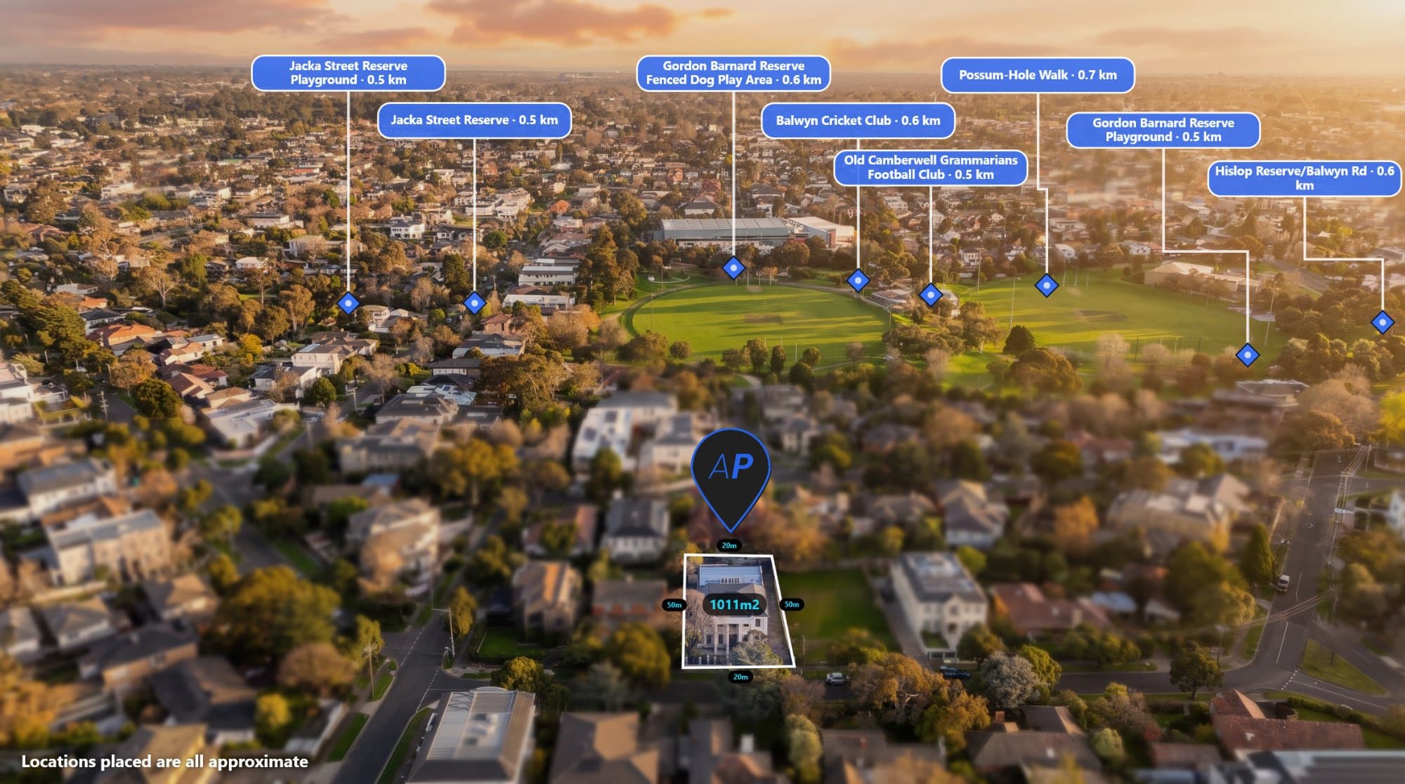
e drone photography for real estate, you already know how powerful an aerial image can be.
A drone photo can show the property, surrounding streets, nearby parks, schools, shopping centres and the overall location in a single image. But turning that raw drone photo into a professional real estate marketing image can take a surprising amount of time.
You may need to find the property's boundary, search for nearby points of interest, add labels, position pins, add measurements and edit the image before it is ready to send to a client.
AerialPin was built to make that process faster.
AerialPin is an AI-powered aerial image annotation and property marketing tool designed for real estate agents, drone photographers, property marketers and developers.
What Is AerialPin?
AerialPin is a browser-based platform that helps you turn a raw drone photo into a professional property marketing image.
It can read information stored in your drone image, including GPS coordinates, altitude, compass heading and gimbal information, and use that data to understand where the aerial photograph was taken and what can be seen in the image.
From there, you can add useful information to your aerial image, including:
- Property boundaries
- Nearby schools
- Parks
- Shopping centres
- Public transport
- Roads
- Points of interest
- Custom pins
- Labels
- Text
- Measurements
- Areas and boundaries
The result is an aerial image that gives potential buyers more context about the property and its surrounding area.
Why Are Annotated Drone Photos Useful for Real Estate?
A standard aerial photo shows what a property looks like from above.
An annotated aerial photo can show much more.
For example, a real estate agent could use an aerial image to show:
Property → nearby school → shopping centre → park → train station → major road
Instead of asking a potential buyer to figure out the surrounding area themselves, the important information is presented directly on the image.
This can make aerial photography more useful for:
- Property listings
- Real estate websites
- Social media
- Property brochures
- Development marketing
- Land sales
- Acreage properties
- Commercial property
- New developments
How Does AerialPin Work?
AerialPin is designed around a simple workflow.
1. Upload Your Drone Photo
Start by uploading your aerial image.
AerialPin supports JPEG and DNG drone images and can read the location information stored in the image. The image can be processed directly in your browser.
Upload an aerial image to AerialPin
2. Find Nearby Places
Instead of manually searching for every nearby location, AerialPin can find nearby points of interest such as schools, parks, retail and public transport.
You can filter results by category and distance before adding them to your image.
This can save time when creating real estate aerial photography for property listings.
3. Automatically Place Pins
One of AerialPin's key features is AI Auto Place.
The tool uses information from the drone photograph to work out which nearby places can actually appear within the camera's view. It can then automatically position the relevant pins on the aerial image.
Instead of manually positioning every label, you can let AerialPin do the initial placement and then make adjustments yourself.
4. Add Property Boundaries
Property boundaries can be drawn directly onto the aerial image.
You can click points around the property to create a boundary, adjust the fill and stroke, and display edge lengths and total area in metric or imperial measurements.
This is particularly useful for:
- Acreage properties
- Development sites
- Vacant land
- Large residential properties
- Rural properties
- Commercial sites
5. Customise Your Aerial Image
Different agencies and photographers have different branding styles.
AerialPin lets you customise pin shapes, colours, typography, borders and leader lines. You can also save styles as reusable templates so future property images can maintain the same visual style.
6. Export Your Finished Image
Once your aerial image is ready, you can export it for use in property marketing.
AerialPin also supports batch exporting, making it easier to work with multiple images or properties.
AerialPin Also Includes AI Relighting
AerialPin isn't only about adding labels and boundaries.
The platform also includes AI Relight, which allows an aerial property photograph to be changed to different lighting conditions.
For example, you can transform a daytime aerial image into a golden-hour, twilight or clear-sky version while keeping the property and surrounding ground consistent with the original photograph.
This gives real estate photographers another way to create more visually appealing marketing images without having to reshoot the property.
Who Is AerialPin For?
Real Estate Agents
Real estate agents can use AerialPin to create more informative property marketing images.
Instead of showing only the property from above, you can highlight the surrounding amenities and important locations buyers may care about.
Drone Photographers
Drone photographers can use AerialPin to offer annotated aerial images as an additional service.
It can also help reduce the repetitive editing work involved in creating boundaries, labels and nearby location overlays.
Real Estate Marketing Agencies
Marketing agencies working with multiple properties can use reusable styles and batch exports to create consistent aerial marketing images across different listings.
Property Developers
For development sites and larger properties, aerial images can communicate information that is difficult to explain with a standard photograph.
Boundaries, nearby infrastructure, amenities and surrounding locations can all be displayed visually.
A Faster Way to Create Property Marketing Images
Traditionally, creating an annotated drone photo could involve several different tools.
You might have to:
- Find the property's GPS location.
- Search for nearby amenities.
- Find the correct property boundary.
- Open Photoshop or another editing application.
- Add the boundary manually.
- Add nearby locations.
- Position every label.
- Adjust the design.
- Export the final image.
AerialPin brings many of these steps into one workflow.
The goal isn't to replace the drone photographer or real estate marketer.
It's to remove some of the repetitive work between taking the drone photo and delivering the finished marketing image.
Why We Built AerialPin
AerialPin was created around a simple idea:
Your drone has already captured the property. Why should it take so long to turn that photo into a useful marketing asset?
Real estate professionals need to move quickly. Listings change, agents need marketing material, photographers have multiple properties to deliver and agencies often need consistent results across dozens of listings.
AerialPin is designed to make aerial image annotation quicker, easier and more accessible directly from a browser.
Start Creating Better Aerial Property Images
If you're a real estate agent, drone photographer, property marketer or developer looking for a faster way to create annotated drone photos, AerialPin gives you the tools to turn aerial imagery into informative marketing visuals.
You can start with 10 free credits without a credit card and explore the platform before choosing a plan.
AerialPin turns aerial photography into property marketing imagery — faster.