
Why Is It Important to Add Labels to Drone Photos?
Discover why adding labels to drone photos matters for real estate marketing. Learn how property boundaries, location pins and measurements make aerial images more informative.
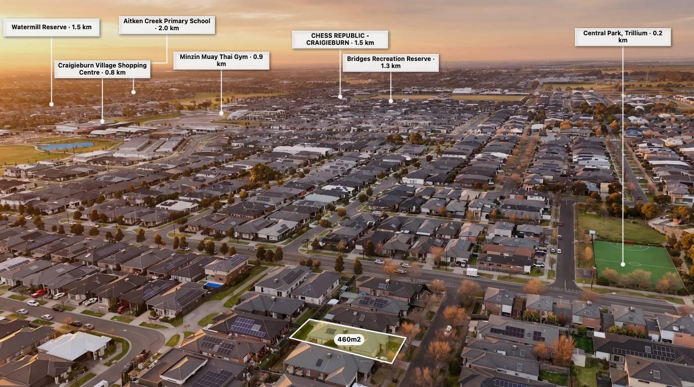
Drone photography gives people a unique view of a property. It can show the size of a block, the surrounding neighbourhood, nearby roads and features that may not be visible from the ground.
But sometimes a photograph doesn't tell the whole story.
Adding labels to drone photos helps explain what people are looking at. Whether you're highlighting property boundaries, nearby schools, shopping centres or important features, annotations can turn an ordinary aerial image into a more informative marketing visual.
For real estate agents, drone photographers and property marketers, this can make a real difference when presenting a property to potential buyers.
1. Help buyers understand the property
An aerial photograph might show a house, surrounding land and neighbouring properties, but buyers may not immediately understand which areas belong to the property being advertised.
Adding labels and boundary outlines helps make the image easier to interpret.
You can highlight:
-
Property boundaries.
-
Land areas.
-
Driveways and access points.
-
Garages and sheds.
-
Swimming pools.
-
Outdoor entertaining areas.
-
Development areas.
This is particularly useful when marketing vacant land, acreage and larger residential properties.
Always use reliable property information when showing boundaries. An annotated drone image should not be presented as a legal survey or substitute for verified cadastral information.
2. Highlight nearby schools, parks and shopping centres
Location is one of the biggest considerations when buying property.
Buyers often want to know how close a property is to everyday amenities.
Instead of simply mentioning these locations in the property description, you can show them directly on an aerial photograph.
Consider adding labels for:
-
Nearby schools.
-
Shopping centres.
-
Parks and playgrounds.
-
Public transport.
-
Sporting facilities.
-
Medical centres.
-
Major roads.
These labels help buyers get a better understanding of the surrounding neighbourhood.
With tools such as AerialPin Nearby Search, photographers can find relevant nearby places and use location pins to highlight them on aerial property images.
Explore: https://www.aerialpin.com/tools/nearby-search
3. Show distances between important locations
Labels become even more useful when combined with distance measurements.
For example, you could show the distance between a property and a nearby shopping centre, school or park.
This gives potential buyers additional context about the property's location.
Distance annotations can also be useful for larger properties where buyers want to understand the scale of the land.
When adding distances, make sure you clearly identify whether the measurement is straight-line distance or actual road or walking distance.
4. Highlight features that might otherwise go unnoticed
Aerial photography can reveal features that aren't always obvious in standard property photographs.
However, buyers may not know exactly what they are looking at.
Adding simple labels can draw attention to important areas, including:
-
Swimming pools.
-
Outdoor entertaining areas.
-
Garden spaces.
-
Separate sheds.
-
Garages.
-
Property access.
-
Nearby waterways.
-
Surrounding infrastructure.
The goal isn't to label everything in the photograph. It's to highlight the details that matter most to potential buyers.
5. Make your real estate marketing more professional
Presentation matters when marketing property.
A clean aerial image with consistent labels, colours and location pins can make a property marketing package feel more considered and informative.
For real estate photographers, this also creates an opportunity to offer something beyond standard drone photography.
You could include annotated aerial images as an additional service, helping agents present properties with more context.
6. Save time with aerial photo annotation software
Traditionally, adding labels to drone photographs has involved manually creating graphics in image editing software such as Photoshop.
This works, but repeatedly creating property boundaries, location pins, labels and measurement graphics can take time.
Online aerial annotation tools provide a more focused workflow.
AerialPin allows users to upload aerial photographs and add:
-
Property boundaries.
-
Custom location pins.
-
Nearby amenities.
-
Distance measurements.
-
Text labels and annotations.
-
Custom styles and visual elements.
Its AI Auto Place feature can also use available GPS and camera metadata from compatible drone photographs to help position nearby location pins automatically.
This means photographers can spend less time manually creating annotations and more time preparing their property marketing images.
Explore AerialPin: https://www.aerialpin.com/
7. Give real estate photographers another service to offer
Adding labels to aerial photographs isn't just useful for buyers. It can also create another service opportunity for photographers.
Instead of delivering only standard drone images, photographers can offer additional annotated visuals as part of their packages.
For example:
Standard aerial photography
-
Aerial property photographs.
-
Different camera angles.
-
Property overview images.
Annotated aerial photography
-
Property boundary outlines.
-
Nearby amenity labels.
-
Location pins.
-
Distance measurements.
-
Highlighted property features.
This gives real estate agents more ways to present a listing while helping photographers differentiate their services.
What should you label on a drone photo?
The information you add should depend on the property and the audience.
| Property type | Useful annotations |
|---|---|
| Residential homes | Pool, garage, driveway, nearby parks |
| Vacant land | Property boundaries, frontage, access |
| Acreage | Land outline, sheds, access roads, water features |
| Development sites | Site boundaries, surrounding roads, nearby infrastructure |
| Commercial property | Access points, parking, neighbouring facilities |
Keep your annotations simple and easy to read. Too many labels can make an aerial photograph difficult to understand.
How to add labels to drone photos using AerialPin
You don't need to build every annotation manually.
With AerialPin, you can create annotated aerial property images directly in your browser.
Step 1: Upload your drone photograph
Choose a clear aerial image of the property you want to showcase.
Step 2: Add property boundaries
Use the annotation tools to draw and customise the relevant property outline.
Step 3: Find nearby amenities
Use Nearby Search to discover schools, parks, shopping centres and other points of interest.
Step 4: Add labels and measurements
Position location pins, add text labels and highlight important distances.
Step 5: Customise your design
Choose colours, icons, styles and layouts that suit the property and your client's branding.
Step 6: Export your image
Download the finished aerial photograph and use it in property listings, brochures, websites and social media marketing.
Final thoughts
Drone photography is a great way to showcase a property, but adding useful information can make the image even more valuable.
Labels help buyers understand property features, identify nearby amenities and get a better sense of the surrounding area.
For real estate photographers and agents, annotated aerial images are also an opportunity to create more informative marketing material and offer additional services.
With AerialPin, you can add boundaries, location pins, nearby amenities and measurements without having to build every annotation from scratch.
Ready to make more informative aerial property images?
Try AerialPin and turn your drone photographs into professional property marketing visuals.
Frequently asked questions
Why should you add labels to drone photos?
Labels help explain important details in an aerial photograph, including property boundaries, nearby amenities, access points and distances. They make images easier for potential buyers to understand.
What labels should I add to real estate drone photos?
Common labels include property boundaries, schools, parks, shopping centres, roads, swimming pools, garages and other important property features.
Can I add labels to drone photos without Photoshop?
Yes. Online tools such as AerialPin allow you to upload aerial photographs and add labels, location pins, property boundaries and measurements directly in your browser.
Can I automatically add location pins to drone photos?
Yes. AerialPin's AI Auto Place feature uses available GPS and camera information from compatible drone photographs to help estimate where nearby locations appear in an image.
Are annotated aerial photos useful for vacant land?
Yes. Property outlines, land measurements, access points and nearby amenities can help buyers better understand vacant land and its surroundings.
Do labels make real estate listings better?
Relevant labels can make property images more informative by highlighting details that may otherwise be overlooked. They should complement accurate property descriptions and other listing information.
Can real estate photographers charge extra for annotated drone photos?
Yes. Photographers can offer annotated aerial images as an additional service, giving agents more informative marketing material beyond standard drone photography.
Related AerialPin resources: